All-In-One Offline Maps
Bored to wait for maps to display? Once displayed, maps are stored and remain available, quickly, even with no network access.
• Want more than just roads on your maps? You will find what you need here;
• Used to go to places with poor network coverage? Everything will stay available;
• Used to go abroad? You won't be lost anymore;
• Have a data allowance limit? It will reduce your usage.
★
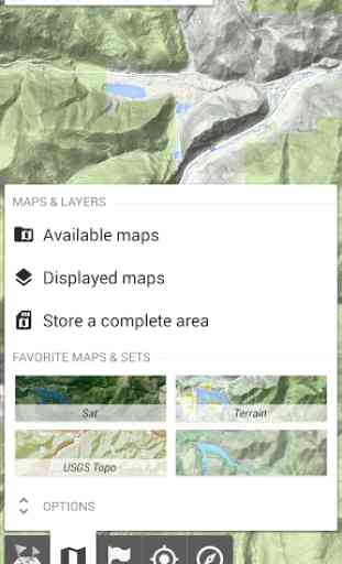
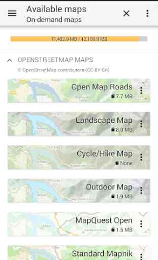
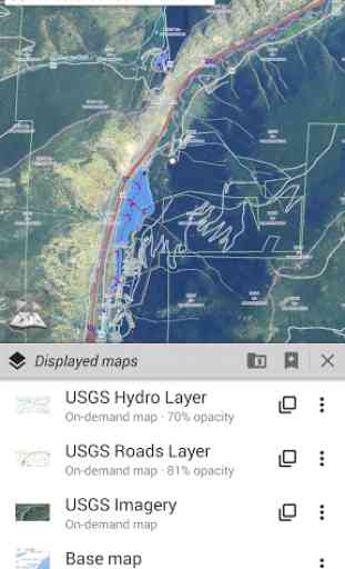
★ Maps ★★A lot of maps are available, including classical road maps, topographic maps, aerial (satellite) maps and various layers that can be added over any maps: OpenStreetMap (Roads, Topo), Google Maps, Bing Maps, USGS National Map (Hi-res topo, Aerial imagery), Worldwide Military Soviet topo maps, etc.
• All maps can be stacked in layers, with precise opacity control.
• Select and store large areas in few clicks.
• Stored space is clear and can be easily deleted.
★
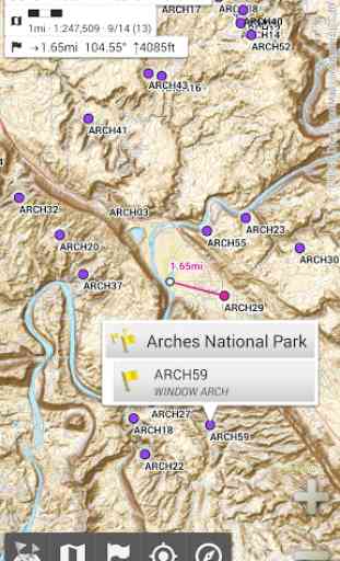
★ Display, store and retrieve unlimited landmarks ★★You can add various items on the map such as waypoints, icons, routes, areas and tracks.You can easily manage them using the powerful SD-Card Landmarks Explorer.
★
★ On-map GPS Location & Orientation ★★Your real location and direction are clearly displayed on the map, which can be rotated to match your real orientation (depends on device capabilities).Easy turn on/off to save battery.
And also:
• Metric, imperial and hybrid distance units;
• GPS Latitude/Longitude and grid coordinate formats (UTM, MGRS, USNG, OSGB Grid, Irish Grid, Swiss Grid, Lambert Grids, DFCI Grid, QTH Maidenhead Locator System, ...);
• Ability to import hundreds of coordinate formats from http://www.spatialreference.org;
• On-map grids display;
• Full screen map view;
• Multi-touch zoom;
• ...
★
★ Need more? ★★If you are a real adventurer, try AlpineQuest GPS Hiking, the complete outdoor solution based on All-In-One OfflineMaps, loaded with a powerful GPS Location Tracker and more: http://www.alpinequest.net/google-play
Category : Travel & Local
Reviews (26)
I've had this app on two different phones before and loved being able to download maps of different kinds , but unfortunately it is no longer usable with this new phone and new network !!! Can no longer download and save anything !!! I have wasted a lot of time and data doing exactly as I used to be able to do with my old phones but Everytime I save anything it is lost , and it is no longer available to save to SD card ether !!!
So far so good, i haven't used it too much yet. I wish managing downloaded maps was easier. (i am aware of workspaces, but in my opinion one should be able to download and delete maps without them)
Just what I wanted. A simple map app that doesnt require me to sign up & can be used offline. The bells and whistles that others mention on the reviews actually sound useful, unlike the other features of other map apps i have downloaded and then uninstalled, although i cant say how well they work because I havent used those features yet.
Before the app was very good and clear offline map but now a days some shades are appearing on the map so that some ways are not clear enough to travel if you fix the problem then I would have given 5str all app is very accurate
Get tool for navigation. Works on land and sea! Offline GPS and map pins makes navigating while sailing without satellite technology convenient. Thank you
Verygood but the feature the geographic site that i wished was out of date...the place has some new developments like new buildings but these buildings were not being seen in the map...need update mapping...
Exactly what I need but why hasn't the Google Maps Satellite layer updated? I'm currently online. There are updated aerials available in Google Earth.
I'm glad I found this app. It distinctively shows railroad lines much better than MapQuest or Google maps.
This is a great app, almost perfect really... Except for one thing: you cannot delete downloaded maps!!! Why wouldn't they create an easy way to manage your downloaded maps??? I have more than 500mb of data used by the app because I can't delete maps I've downloaded for past trips... 😤
Its the best application ever.....if you don't want to get lost on your way to a check point/ target pls use this application.....very easy to use en accurate.
Excellent. Commercial and recreational boat friends swear by it. Very accurate. The best and most accurate I have found for close in navigating around reef and isolated bombies on the Great Barrier Reef in Australia.
Other offline map apps are simple: Download the map of the country that you want, and you can view that map at anytime, no further connections necessary. That's whole point of an offline map, you can view the map offline. This is not that kind of app. I can view many different types of detailed maps from different map providers all at once. But guess what? I cannot view any of them offline. There no saving any one country, and it only can save in small sections. If I have to change course, I'm screwed. So no thanks. Until I can save the country for at least one of those maps, it's useless as an offline map. Although it is terrible offline map, despite the name, it's an excellent online map. I would give it a 5 star rating if that was the case. However, you know, the "offline" part is pretty important for what you are advertising.
Way better than Ovital. I just love the ability to layer different map sources and flip between the two, adjusting the saturation to bring out detail. The add-ons are great value for money too. One recommendation for the dev is to find a way of downloading all layers of an area, rather than having to zoom in to each layer in turn. That would save the RSI in my hand! Great work, love this app.
I've looked at most of the one-star reviews complaining that this does not work offline and I can confirm most are complete gibberish. It really does work offline but clearly you have to download the maps first! Duh! It's excellent for walking in the UK and probably elsewhere too. It's a map, not a navigator. Get a Tomtom if you want that. Online help/tutorials are not good and this is probably the greatest weakness. You have to invest an hour or two to understand the developer's mindset.
I've been trying GPS apps. I backed one on Kickstarter, that always seems to have issues. I took a quick look at this and I liked what I saw, then I started digging. This is the first app that I have used that accurately shows me what is downloaded easily. One other rquires me to toggle in and out of on-line mode to look. it's annoying. Everything is well thought out. I love it. Spend some time looking at it and you will be impressed.
I feel this app has an amazing potential to be on -off grid. I had difficulty closing it on android, or minimize it, (until I discover the options on the bottom by tapping it. a training video would be a plus. i finally figure it out how to create a target, and also to remove it. what can i said i like it. but for those impatient ones , and less techie, this would be a challenging App. you may not have to change anything just create video for navegation and the use of options. Peace!!
This is the best map app I've ever used. I've used it for years and it's always worked in the woods without internet. I have only one suggestion, maybe you could make the download speed a little faster because my wifi can download at 10MBS and its only doing it at like 1 or 2. Also, maybe you can have an agreement with google to save Google maps that would be awesome. Great app, keep up the good work!
Brilliant app, but there are 2 issues. The name of mountains and points of interest etc. are too small, even on a 6.4" screen, please add an option to make the writing larger. Also the app miscalculates the time to walk a given distance, often saying it will take hours to walk hundreds of feet, it then continually recalculates until the stated time vanishes. These are the only small issues in an otherwise fantastic app.
Wide range of maps available to download and use offline. Includes downloading satellite images. Overlays for maritime buoyage, aircraft routing, terrain, ocean features, additional names of places, light pollution and a whole load of other stuff. You can blend maps to produce the most exquisite looking maps that you cannot find anywhere else. Bit of a learning curve to find your way around all the features but we'll worth persevering. Good response from developer. Six stars for this one.
This is the only Map application I use and I love it. First I save a map of my whole work area and then I always have my maps even when I have no network or WiFi access. My job depends on me knowing where I am and where I'm going, so this is the most important app on my device and it never lets me down. I'd recommend this app to anyone looking for a complete offline map with plenty of additional options to make getting there a bit easier.
One of the best free maps&navigation software on the market, perfect for areas without any internet connection (if you saved the maps beforehand of course)! Pros: easy to use, while having a lot of available functions (for example: placemarks, user-defined areas for pre-downloading); large selection of available maps; stable, clean and responsive. Cons: high price for paid app modules, though some may find them very useful; no auto-route functions (or I just haven't found one).
Very useful mapping app. No ads and not overly cluttered. Impressive list of available maps and even more on the community list. Useful for creating routes in places where there are no roads, hiking, kayaking etc. Update June 2019 Have been using this app for hiking around trails in North Vancouver. I continue to be impressed by the functionality of this app.
Easily the best I've tried by a mile. Very intuitive and easy to use when marking waypoints / areas etc. Took a bit of playing around to work out how to group export but not too long. Used in field a few times now for different tasks each time (ecology related) and can see it's going to be a trusty companion.
Dear Team, there is a problem, i was using this app in android 10 version mobile, after changing my mobile now i have android 11 version phone, i shifted tha whole data from my old phone to new, but this app is not exploring my old data, please fix this problem
In the old version of this app when you export or share an object such as an area for example by a social app(such as telegram) to another person which has offline map ,the recipient with a single click can see the object and it automatically was saved on her device and app. The older version in ((export as)) had 4 options which the forth one did what I mentioned above without need to share or etc. But the new version has 3 options. Now send and save the object on the other devices is complex
By far the best map displayer. Availability for grid for any format imaginable, tons of apps to choose from, many with conturs and height displays. The compass, height display, direction line ect work great. There has been no ads, even without paying money. In-App purchases are very limited to the most niche features. It baffles me how good this app is.