BackCountry Navigator TOPO GPS
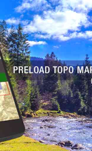
Download topo maps for the US and many other countries in advance, so you won't need cell coverage for navigation. Use storage memory for maps.
New: Android Wear support to see navigation at a glance on wrist
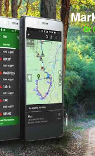
Use GPS waypoints from GPX or KML files, or enter your own coordinates using longitude/latitude, UTM, MGRS, or grid reference. Using GOTO makes a waypoint a locus for navigation.
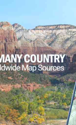
This uses many publicly available map sources as free downloads. Some additional content available as an in app purchase:-Accuterra Topo Map Source for $19.99/year. This can be purchased and used with or in instead of the free sources.
- Boundary maps for 12 western states from the Bureau of Land Management(BLM) Overlay for topo maps valued by hunters. -GMU boundaries in some states-Lake Contours in several states. -Content from US TrailMaps including:-ATV, Whitewater, and Equestrian Trail Maps
See the menu under More-> "Purchasing AddOns". They can be shown on top of topo maps.
You may try the DEMO version to make sure you like the maps in your country.
About topo (topographic) maps: Topo maps show terrain through color and contours, and are useful for navigation offroad. Topo maps and GPS can be used for hiking, hunting, kayaking, snowshoeing, & backpacker trails. You can create your own maps with Mobile Atlas Creator, or specify a custom tile server. Built in sources include:OpenStreetMaps from MapQuest OpenCycleMaps showing terrain worldwide US Topo Maps from Caltopo and the USGSUSTopo: Aerial Photography with markup. Canada Topo Maps from ToporamaMarine maps: NOAA RNC Nautical Charts (coastal)USGS Color Aerial photography Topographic Maps of Spain and Italy Topo maps of New Zealand Japan GSI maps.Many of the above sources are generally free to use.
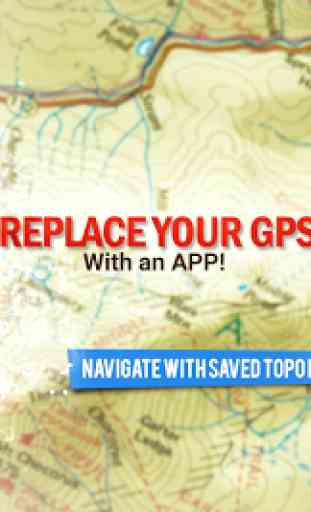
Use offline topo maps and GPS on hiking trails without cell service. The GPS in your Android phone can get its position from GPS satellites, and you don’t have to rely on your data plan to get maps. Have more fun and safe GPS navigation in the backcountry.
Use as a geocaching navigator by getting a pocket query as GPX. Besides geocaching, use GPS for recording tracks and GPS waypoints on your trip, all the while tracking your GPS quest on topographic maps. It may replace your Garmin handheld GPS.
Here are some of the outdoor GPS activities BackCountry Navigator has been used for:As a hiking GPS both on hiking trails and off trail. Camping trips to find that perfect camping site or the way back to camp with GPS. Hunting trips for hunting wild game in rugged areas. Doing recon for a hunt or as your hunting GPS Fishing: make it your fishing GPS. Search and Rescue (SAR). Trekking the Pacific Crest trail or other long term hiking. Kayak and canoe treks on inland lakes and streams or marine, coastal waters. Backpacker trips: using topo maps of wilderness areas and national forests for navigation on trails with the GPS in your rucksack or backpack.
Find your own ways to have fun in the outdoors. Be a maverick by venturing beyond cell service boundaries with your GPS. Become a pro at navigation with GPS for the outdoors.
BackCountry Navigator has been on WM devices and preloaded on the Trimble Nomad outdoor rugged device. This Android version is more flexible, featured, and fun. Create a memory with maps.
For a one time fee, this a great addition to the outdoor gear you bought at Cabelas, REI, or another outdoor store. Many have found the Android GPS in a phone or tablet to substitute for a Garmin GPS or Magellan GPS, such as the Garmin GPS units Montana, Etrex, or Oregon. Android can be your handheld GPS.
Category : Maps & Navigation
Reviews (15)
This app worked extremely reliably for many years and has helped me on numerous outdoor adventures in the past. I prefered it above all other similar apps because it did not require me to create an account just to be able to use the app. After recent updates it has become completely unusable for me because it keeps displaying a message saying "Internet Off, See Layers Menu". I have confirmed that the "Internet Enabled" option is turned on. Reinstalling, clearing data/cache did not help.
What happened to this app? I paid for pro and I've been using it for years. It used to be great. Got a new phone and went to use it while I was out on a walk and it took a few minutes of clicking through permissions and other nonsense before whatever that migration was that didn't work. Now it seems like the map sources aren't loading and a bunch are talking about subscriptions.. I'm going to find a new hike tracker.
Not sure what these guys have done... i recently re-purchased the app (used other backcountry aps before) and have to also purchase the underlying map... what's the point of purchasing the app? So it can read the map that you also have to purchase? Unless I'm somehow mistaken, seems like a better idea to just purchase another app. Very poor communication on this. Might try out alltrails next time - definitely a different one.
Used and loved this app for 7 years, and had recently been using it in search and rescue. Folder migration failed, and lost 7 years worth of downloaded maps. I can no longer access the (better IMHO) green FS topo maps as they seem to have all been replaced with newer white/ brown ones. Contacted support, waited a week with no reply, contacted again, still waiting on reply. Seems like support is non existent, and a one great app is now garbage.
App was brilliant but opened it today and did the data migration. And my maps stopped working, I tried to browse for them (in app) and they don't show up. But after browsing outside the app my map files are still present it's just the app doesn't recognize them anymore :(
Pretty decent app for navigating while hiking. Not so much when navigating while Overlanding. Five stars for hiking. Two stars for Overlanding.
I've been using it for years but now for some reason free maps are not downloading in full . lot's of tiles missing at various zoom levels. The subscription maps are downloading great. It seams they do it intentionally. I tried on 3 devices with the same effect.I feel that with intruduction of subscription service this app should be free to download...I paid £12.5 and I feel cheated.
First class navigation app... What a great so. You down load all the maps you need and go from there. No signal issues and is completely reliable. Theory is no limit to the maps I can download. The only thing I wish it had was Imperial miles and feet as I live in the UK. Otherwise it can't be faulted.
Will not import maps after last updata. The app is worthless now. Would not recommend. Stay away.
I've used this app for years, includin the prior paid one and was one of the first to support the Kickstarter. So I'm invested in this app and want to use it. But it's too cumbersome. Each action requires pages of instructions to use. Nothing is intuitive. The maps are also dated compared to other apps out there. While this works ok, the experience is frustrating and requires too much effort to use effectively. I've switched to onX and can't be happier.
All these gps tools with offline maps are a bit quirky. However this one has consistently worked well for me. I paid for the accuterra maps and that has really made the difference. I really like being able to name map packages and then switching to the relevant map for my trip. Same thing goes for the trip database and waypoints. I do wish that Google maps were available. They are of little value in the Backcountry but it is easier to locate places with them.
Only been using it for about a month. Still getting used to where to find features. There are a fair amount of maps available online and downloading sections for off line viewing is pretty good once you get used to it. I have found that it's easy to get lost around the map center if you are viewing a section that is not immediately in your area. Trying to stay zoomed to the right section can be tricky. I do a full walk through on my YT channel...Rough Riders Off-road.
The app worked for about a year. Recently the app randomly deleted all of my waypoints. I talked to customer service about it and they said it wasn't a "known bug" and they left it at that and started ignoring me. The app then proceeded to completely die on me and make my phone almost unusable until I ran it in safe mode just to delete this app. I recently tried a reinstall and it's just as broken. When using an SD card the app is impossible to get to load both your saved maps and waypoints all from the same area. Recovering files for the app is NOT user friendly. The overall layout of the app is beyond cluttered and a lot of options could be minimized. I wish I could get a refund for their now defective app but as I said, their customer service started ignoring me. Horrible customer service.
I really like BCN. I've used it for years and works well. Its done everything I've asked. There is a learning curve. Very flexible and gets the job done. With that I feel that they've let it get out dated due to their new focus on XE software coming out someday. Look at their website and you'll notice things haven't been touched in years. Not a lot of refinements or updates specially when there's a lot of competition- Gaia, LeadNav and a lot of others.
I had used this app for years with minimal issues, until a few days ago when I opened the app and suddenly some of the satellite map source would not load at certain zoom heights. Quit the app and reopened it to find all of my well over 100 GPS points had disappeared, and now my favorite source arcGIS no longer functions at any zoom elevation. Uninstalled and reinstalled to the same issue. Years of work completely gone. If you want any hope of a reliable service, look elsewhere.