
GIS Surveyor - Land Survey and GIS Data Collector
To raise a ticket, find a link below ↓↓
GIS Surveyor is a GIS application meant for GIS survey, GIS Data handling, data collection, analysis, and planning before execution of a project. It allows professional surveyors with an opportunity to collect more accurate survey data in a stipulated time frame. This application is also a GIS remote sensing application that can be used for GIS Mapping.
GIS Surveyor is a GPS/GNSS based survey application that uses GPS data collection. It will be used for various types of environmental surveys and field surveys while also enabling the GIS data collection to be faster and efficient.
This application can be used for Field Survey,Land Survey,and other surveys which includes field data collection including internal GPS or external GPS.
-Top GIS Survey Application features:
- GIS data collector
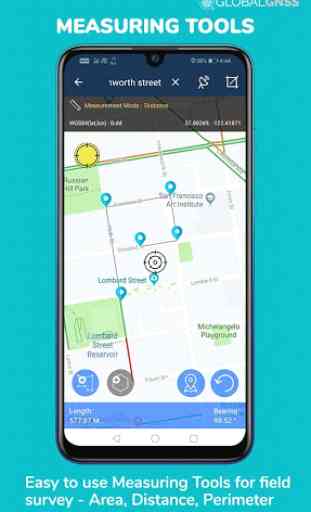
- Calculate the area and distance.
- GPS land area calculator
- Attributes can be imported from any other project or device.
- Survey using images for any location is available, with multiple export options.
- One set of attributes can be used across multiple surveys.
- Various Export file formats for GIS data are CSV, KML, and GeoJSON.
- Post process of data can be performed with software like ArcGIS, ArcGIS online or qGIS.
- With external Bluetooth GPS/GNSS device connected, NTRIP/RTK data can be utilised for accuracy.
- Survey on online gis maps, and GIS offline maps(supports mbtiles)
- WMS and WFS Surveyor tiled maps are supported, load topographic and orthophoto maps, geological surveys, cadastral information.
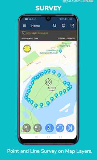
- Currently 4 methods of data collections are supported, GPS / GNSS location, map cursor location,GIS Tracker, point projection using angle and distance.
-Mapit GIS survey on multiple kinds of GIS maps.
- Direct export to Dropbox,Google Drive, FTP location.
- Import point, line and polygon layer in CSV, KML or geojson file.
- Possibility to view multiple layers including points, lines and polygons at the same time.
- Possibility to group the data into survey layers - each survey layer may have a default set of attributes.
- Create new polygon or line features and measure details like area, length and perimeter.
- Backup management.
- Export in .SHP format .
- Export in GPX format..
- Works with GEOID Model to provide elevation for a point.
- Recieve Mock Location from 3rd party application.
- Coordinate System Geoid EGM96
Industries that our survey application caters to:
- Forestry and Timber inventories.
- Residential Land, Commercial Land, and Government Land.
- GPS surveying and GNSS survey.
- Land Survey.
- Agricultural and Farm Survey.
- Field Surveys.
- Environmental Systems.
- Highway Road surveys.
Supports Android OS 4.4 and above
This application is made ads-free and hence it will increase your productivity. If you have any problems in installing or downloading or if you face any kind of issue with the application functionalities kindly raise a ticket at: http://globalgnss.com/support/
Visit us at www.globalgnss.com.
Category : Maps & Navigation
Reviews (29)
No ability to manually enter a point? I'm at a loss how anyone finds this application useful. There is no option to manually enter GPS measured points to define areas. The only method I see is moving the map around with your finger and creating a waypoint under the cursor. Seriously?
It is nice though it is in beta version yet it is useful. It would be more convenient if I can add layers or themes from external files like .shp files and other compatible formats.
Clean, simple interface makes this app incredibly useful and easy to use. Love it for making simple maps and measuring area and perimeters! Glad to have it on my phone!
GIS is great collector data. Clean interface and easy to use. I really like this app it is very useful.
Has lots of features but it really requires time to figure out how to use them all and just do something really quick that's impossible so I guess it's okay but for my purposes not okay
How can this application be useful to a licensed surveyor without the ability to manually enter points (from say a theodolite - total station). Without it, this app is a toy.
Cant add kml file. The import function showing my kml file but after selecting, the app is not showing on screen. Why?
Didn't work period. Didn't save coordinates, didnt record distance, nothing. Worthless waste of time.
Very good app. Be even better to set the satellite measurements down bellow 1m
It is impossible to import a kml file. It just keeps telling me the kml file is not in the import folder but it is impossible to find the import folder.....
Unable to find servey number and I think user manual also deleted.
Demands personal information and subscription just to open it. Look somewhere else for a better company.
3 days use what a joke. Then buy! Didn't use as I am not a pro and need time to figure out. They sell the email address for income most likely.
In trail version Is this application uses internal gps of mobile If yes Why point didn't get selected on earth Point get selected on vertual cursor
Wants pay to use after a small trial. No thanks. Get the same data online for free.
how do you import kml file to this app..i try adding the kml file to import folder but nothing happen
It will not export points I created to my linked Dropbox account? Just trying to export my points in csv format...please advise. Thanks, Frank N8748908
Cant this application be used Nigeria because there is no nigeria feature on the units & coordinate feature in the setting
Why does this app need access to my pictures and videos?
Download the 1.5 version but keep asking for update to 1.4 version. Very confusing
So complicated to use. After an hour of trying to figure out how to measure my field i gave up
Practically somehow good but the trial is just for a days
Couldn't find the Import folder
Not used for land measure
Good apps for own & others
This application is very important for my job
Would never accept email
Intresting
The app is a great survey tool. With a lot of features. I will be using this app along with a gnss reciever to map agricultural underground drainage lines. When I first tried the app it wasn't clear how to use it, so i down loaded the user guide. The user guide is a must for a beginning surveyor to get started and it is still going to take some time figure it out. A nice feature, would be to list the call points and the coordinates on the page where you can see how many call points you have.