Polaris GPS Navigation
That is just a glimpse of the navigational power you will hold in your hands when you install Polaris Navigation GPS.
Used mostly as a hiking, off road, nautical and trail GPS app, Polaris is an excellent backup or replacement for your Garmin or other handheld GPS satellite navigation unit and will keep you oriented wherever your outdoor adventures take you!
Typical usage:
● Hiking tracker● Back country exploration● Trail recorder● Sailing, Boating● Fishing. Find your favorite fishing location!● Hunting● Geocache● Camping● Mountain Biking● Backpacking● Compass orienteering
Known for its stability, reliability and flexibility, Polaris is used by land-sea search and rescue, military personnel and millions of others worldwide.
With Polaris, you get free access to our map library with hundreds of downloadable offline maps and most of the online maps in Polaris are cached for offline use. You even have the flexibility to build your own maps from a variety of sources using the Mobile Atlas Creator map tool.
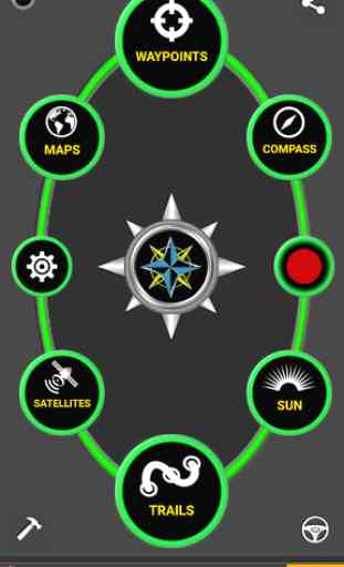
This powerful navigation system also includes:
★ GPS Compass and Magnetic Compass
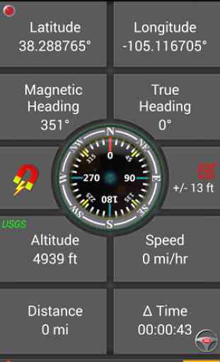
★ Panels for all standard GPS parameters
★ Odometers, altimeters, speedometers, chronometers
★ No subscription fees. Does not require any special accounts
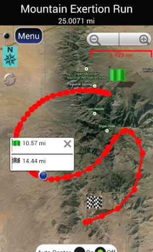
★ Tap anywhere on a recorded track to get split distances to track endpoints
★ Robust waypoint and trail management systems
★ Plot or draw a trail and navigate it
★ Google Maps, OpenStreetMap-Mapnik, Topographic Maps, Cycle Route and Hiking Maps, Vector Maps, USGS Topo Maps, NOAA Marine Charts, World Aviation Operations Charts, Canada Toporama.
★ GPS Tools and GPS Satellite Diagnostics
- satellite count, location, signal strength and more.
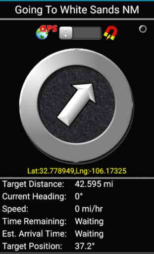
★ Waypoint navigation system including a dynamic waypoint-finding compass that always points to your destination while reporting estimated time of arrival, distance to target and other statistics. Just follow the arrow!
★ Trail navigation system
★ Trail altitude profiles
★ Location Sharing
- Receiver gets a map with your position.
★ Coordinate formats: latitude/longitude as degrees, deg:min, deg:min:sec, and UTM (Universal Transverse Mercator).
★ Military Coordinate Finder
- Military Grid Coordinate Reference System (MGRS).
★ Hiking Trails
- Most of the maps show hiking paths courtesy of the Openstreetmap project. We are always amazed to find that even some of the most obscure hiking routes in our state are available.
★ Marine navigation
- NOAA Nautical Charts and Openseamap for selected areas.
★ Select source for altitude reporting: Satellites, United States Geologic Survey or map your location to the results of NASA's Space Shuttle Radar Topography Mission
★ Data protection
- Your data is backed up regularly meaning you will not lose your progress should your battery need replacement while en route to your destination.
★ Waypoint photography.
★ CREATE MBTILES BASED MAPS FOR OFFLINE NAVIGATION. INSTRUCTION VIDEO AT: http://www.youtube.com/watch?v=Y3RtFvPna1A
★Map Search and Coordinate Conversion capabilities with the free MapIt! plug-in
★ Improved compatibility for maritime navigation with addition of nautical and NOAA marine charts.
★ Road navigation and street directions are provided through a digital pipeline connecting the power of Polaris to the Google Maps app on your device.
Category : Travel & Local
Reviews (18)
I use it for navigation here on the waterways of Jacksonville. Very accurate postioning with excellent agreement of map depths and on-board depth meter readings.
So far so good. Polaris puts it all the things you need for off-roading together in a single interface. Well done!!
Worked great while hiking today. Stopped when I went onto a different trail but it could have been me bumping it after I checked it and was putting my phone back in my pocket..
This app appears to have all the whistles and bells-- just starting to use it but impressed so far...
This by far the app to ever use. It helped me creat water route for my farm gravity water. Thanks team for the great app
A bit clunky, but has a wealth of features. It’s okay for free, but you can only save 3 routes at a time. Possibly if purchased it unlocks more features. Doesn’t seem to keep a time on your routes which I would have liked and only has elevation and plotting. The good is there are lots of map vectors which is very cool. But, I’m still looking
In my opinion, it's the best GPS app out there by far. It's perfect for I use it for. I do a lot of 4x4 and hiking in the back country of Colorado. Nice how you can "waypoint" and record your trails. It seems to me that it would be almost impossible not to find your way out with app. Ease of use is another great commodity of this GPS app. Never hit the back country without it. Fantastic job on its creation and updates guys!! You have a winner here!!
I tried the free version First and was disappointed I thought that if I paid for the other version GPS waypoints navigator that it would be better. It isn't. It's still just draws a straight line from one position to the next it does not show the exact Trail at tooth taken. Furthermore in comparison to other products the maps are not as good.
Doesn't work... I set a waypoint this weekend on my hunting tree stand. When I returned in the morning, it was incapable of finding the waypoint. It would say it was 260 feet south, then it would say it was 277 feet west, etc. Nothing consistent. When I got near the tree stand (through my physical memory) and was standing within about 60 feet of the stand, but where I could see the stand, it said it was 250 feet in the opposite direction of the stand. That's what I mean by it doesn't work. It points the wrong direction, it points in inconsistent directions (one time east, one time west) and inconsistent distances.
It is easy to use and has good features though I have not used it much. I downloaded the vector map of Zambia but when I tried to open, a different map was opened. What could be the problem?
Easy to use and gives great value. Oftenly use for our weekly sailing.
Nice app... We are using this app for fishing. I'm fisherman. I know little more English only. This app is giving salary. But we save 6 number only .
Complete confusion. When I upgraded the upgrade app had a different name so I kept going back to the original app with ads. Nowhere was I advised of the new app name. Free version did ask if I wanted to transfer my trails to this new app with another name. Finally figured out this was the upgrade and not someone trying to hijack my computer. I admit, I mostly use IOS on iPads and never see this type of upgrade. All said, free version was buggy and locked up on each page. Paid version seems ok.
Trying to find the differences between this one and the other called 'GPS WAYPOINTS NAVIGATOR'. They seem to be the same app with different names and icons.
Better than expected for a free app! I recorded a hike and waypoints, with pics, on the 1st try. Upgraded for day 2. Just imported my trails to Google Earth on my PC. Love it! Works as expected, except: I changed colors for my 2nd recorded trail (red and green) but they both display blue in GE Pro. I can't select the trail to modify properties in GE.
Please put a space in the middle of the 10 digits you show to represent the UK OS co-ordinate so that I can see where the Easting ends and the Northing begins. You might want to consider showing fewer digits too. On a paper map 3 will do. 5 digits is an accuracy of 1 metre. 3 metres or so is the best that most GPS hardware can manage. Ads are full screen, intrusive and seem to encourage the installation of further apps. I nearly got caught out by a very dodgy looking one.
It has a lot of useful tools that other apps charge for. What I can say is really good job.
Moved into an area l was completely unfamiliar with surrounded by almost 100,000 acres. I downloaded the appropriate maps and figured out how it worked. And off l went. The trail marker feature was unbelievably accurate. The best part is no data is required!!! This lil beauty stands alone as long as the satellites can cya. You can choose magnetic north or GPS. I use a G pad 5 tablet. I used the free version only. No tutorial so learn b4 ya go and dont rely on just one thing. Really great app!!!