Polaris Ride Command
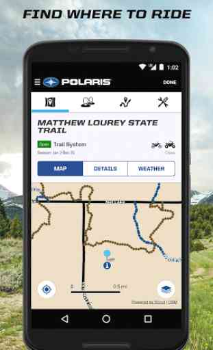
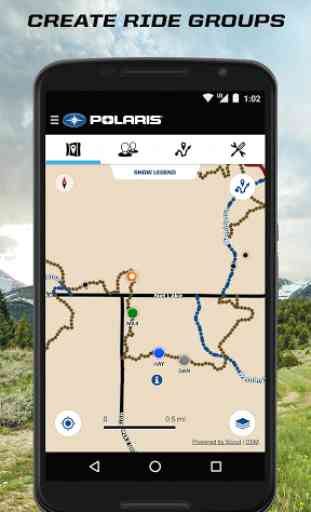
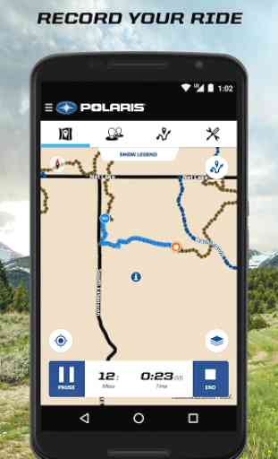
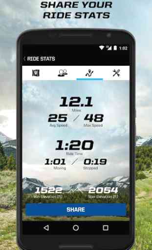
- Version 5. Step into the rider’s seat with this all-in-one specially designed app that elevates your riding experience.Known previously as ORV Trails by RiderX, the Ride Command app, exclusively from Polaris, continues to deliver the same features riders have come to rely on – offline maps, over 300,000 miles of off-road trails, points of interest including restaurants, lodging, gas and medical. After the ride, your personalized garage allows you to keep tabs on your vehicle so it’s always ready for your next ride.Now, you can take off-roading to the next level! The Polaris Ride Command app lets you connect with your vehicle via Bluetooth to track your rides, check vehicle health and sync waypoints. Connect with friends for a Group Ride – see where your buddies are, get out of the dust trail, call or text directly if you need help. Share the Experience with tracked ride stats you can email, text or share across your favorite social network.Ride Command is a registered trademark of Polaris Industries Inc.Continued use of GPS running in the background can dramatically decrease battery life. Recommend running with power source.Running the Ride Command app without cellular connectivity will show most recent friend locations. Once you re-enter a cellular network, the Ride Command app will automatically re-connect to your RZR 1000 LE 7” touch display.
Category : Lifestyle
Reviews (18)
This app is great, first trip out today with this app. Simple to use, very detailed map display. Easy to use and save trails. Shows all the trails in the area. Will not go off-road without it.
App is great, It would be nice to be able to delete your own condition report. Had a few that didn't not want to put the place marker were I wanted it. One even popped up in the middle of Lake Michigan...
I thought this app would show the atv trails around where I live but it doesn't. It just shows the same as Google maps
The app works great for me! Bluetooth data tethering now works great, keep up the good work
Awesome!!!!!!!!!!! Too awesome to be just for Polaris riders only....!!!!! full function wanted for others too please!!! because Im a SkiDoo girl big time! .....but, but i must admit that Polaris has been impressing me lately on many things that they do!!!!!!!!!!!!!!!!! ahhhhh....., probably its time 4 me to switch to Polaris????
Great app! Displays information better than Google maps and way easier to create custom route plans integrating offroad and on road options.
Used for 2 years on my phone and now keeps freezing when I open and log in. It seems fine if you want to use as guest, but as soon as I log in, the app becomes unuseable. Very disappointed. Update: Why haven't I received a response yet? I'd like to see a resolution on the problem.
Great app for offloading in general. Sharing planned trips makes overnight trips much easier.
Does not appear to be accurate. Walked 50 feet in a straight line. App said I had gone over 100 feet and made 3 turns and crossed back over my own path. Maybe app is only made for moving faster (like on atv) or going farther than 50 feet. Seems to me if it can't get 50 feet right, I don't stand much of a chance getting my ride right. Also maps are very blurry when zoomed in.
Really excellent app, I use it all the time and I'm quite happy with it. I wish it had more lake, town and road names though. Maybe it could somehow communicate with Google Maps? Can be used if you don't have service you just have to be sure and not to X out of it. Make sure to set the app to be always on and manually close it when you're done. The playback & share features are really nice also.
The waypoints are a good feature but the purpose in having them is to plot a course, save it and use it when ever you want to. You should also allow users to name the course and include a reverse course feature to navigate back home. I use an app for my boat that offers these options and it is amazing. If you have to charge for an upgraded, then do it...people will pay for it. You need to add this feature otherwise the waypoints don't serve much purpose. Thanks.
The current edition lost all my info. It lost the info on vehicles and my service records. When I went into the app, in the map function the orientation was always wrong. No matter how I turned it, it kept turning so everything was sideways. When I would turn it so I could view it in portrait or landscape it would shift again. Between losing all my info and service records... The map deal has rendered this app worthless! Now the cherry 🍒 on top is the app won't even open to my profile. GARBAGE!
maps are very detailed on the paved roads, but the trails ..meh. The maps in the rzr are so so, and hit and miss. Meaning very detailed in one area, come around a bend or something and it's really vague. Lakes are no longer blue , the same color as the ground. Overall it's ok. Needs some work
When you view any of your saved rides there is a 'details' window that opens. This window nearly takes up the top half of my phone screen which limits actually viewing your ride map. I contacted polaris and they said there's no way to remove the box. If you close the box it closes your m as p as well. This app is great if they would enable the box to be closed. Searching for another app.
I love this app. It's the easiest to use trail finder.
I've been using this app for local rides, and have been satisfied with it; even more so, ever since it's been offering the flyover views. It's great that it incorporates photos taken along the way. The tilt and pan features make for a great customized view of the surrounding terrain.
Works great on phone app. But can't seem to hook up to rzr command.
Great app for navigation however during each update you have to reload all your saved maps for offline navigation. Not cool considering you may not beware that it's been updated then you go to the trail and find out that your map isn't there any longer!