US Topo Maps Free
**
* Please use USGS National Map or OSM if you need most recent maps ***
Choose between >20 map layers (topos, aerials, sea charts, flight charts, ...)
Turn your Andoid Phone/Tablet into an outdoor GPS for trips into the backcountry.This app gives you similar mapping options as you might know from Garmin GPS handhelds.
Main features for outdoor-navigation:
• Download of map tiles for OFFLINE USAGE (PRO-VERSION ONLY !)
• Display Real-Time nowCoast Weather Information and NEXRAD Weather Radar
• Free access to more than 100.000 seamlessly stitched USGS topographic maps
- easy to use as browsable map layer
• Create and edit Waypoints
• GoTo-Waypoint-Navigation
• Create and edit Routes (PRO only !)
• Route-Navigation (Point-to-Point Navigation)
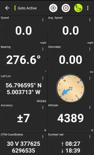
• Track Recording (with speed, elevation and accuracy profile)
• Tripmaster with fields for odometer, average speed, bearing, elevation, etc.
• GPX/KML/KMZ Import/Export
• Search (placenames, POIs, streets)
• Customizable datafields in Map View and Tripmaster (e.g. Speed, Distance, Compass, ...)
• Share Waypoints, Tracks or Routes (via eMail, Dropbox, Facebook, ..)
• Use coordinates in WGS84, UTM or MGRS/USNG (Military Grid/ US National Grid)
• Get NWS Weather Forecast
• Track Replay
• and many more ...
Available map layers:
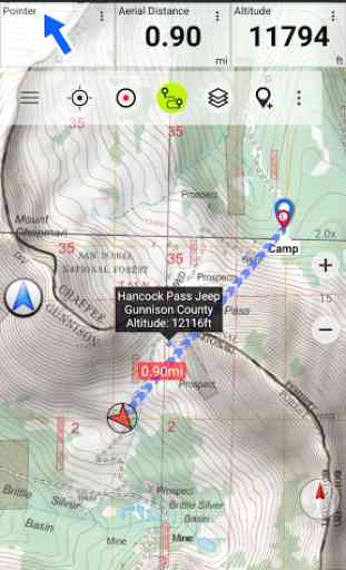
• USGS DRGs: Seamless coverage of topo maps of the USA at Scales 1:250.000, 1:100.000, 1:63.000 and 1:24.000/25.000
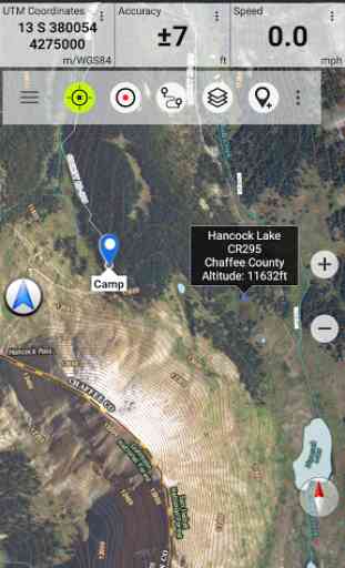
• USGS High Resolution aerial imagery
• USGS National Map
• Orthoimagery for conterminous US
• Google Maps (Satellite images, Road
- and Terrain-Map)
• Bing Maps (Satellite images, Road-Map)
• Open Street Maps
• Earth At Night
• FSTopo Forest Maps
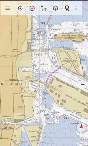
• NOAA Nautical RNC Charts
• Public Land Ownership (Padus)
• Flight Charts
Available map overlays:
• Hillshading overlay layer for OSM, Google or Bing maps (PRO-VERSION ONLY !)
• Ridge Weather Radar NWS
• Wind, Temperature, Pressure
• Wind Vectors
• Precipitation Estimate
- 1-hr
• Precipitation Forecast 24h
• Surface Air Temperature
• Hazard Warnings
• Tropical Cyclone Track
• Wind Vector Forecast 24h
• Max. Air Forecast 24h
• Min. Air Forecast 24h
USGS DRG topographic maps:The 7.5-minute maps (1:24.000/1:25.000) are the best maps for outdoor activities in the USA. Although some of the maps are quite old, they contain many small pathes and 4WD tracks that are missing in new USTopos, Google, Bing and OSM maps.
New US Topo Maps:US Topo maps are a graphic synthesis of The National Map data files and are produced in the familiar 7.5-minute by 7.5
- minute geographic format. Current US Topo map layers include an orthoimage base, transportation, geographic names, topographic contours, boundaries, hydrography and woodlands. Also included are the Public Land Survey System (PLSS) and the United States National Grid.
NAIP Orthoimagery:Seamless coverage of contiguous US with 1m/pixel resolution
HRO aerial imagery: High resolution arial photos covering US urban areas & borders (up to 10cm/pixel)
Use this navigation app for outdoor activities like hiking, biking, camping, climbing, riding, skiing, canoeing, hunting, snowmobile tours, offroad 4WD tours or search&rescue (SAR).Add custom waypoints in longitude/latitude, UTM or MGRS/USNG format with WGS84 datum.Import/Export/Share GPS-Waypoints/Tracks/Routes in GPX or Google Earth KML/KMZ format. (PRO-VERSION ONLY !)View Real-time nowCoast weather information like temperature or windvectors and overlay to map. See animated NEXRAD rain radar to make accurate predictions when raining will start/stop (PRO-VERSION ONLY !).
LIMITATIONS OF THIS FREE VERSION:
• Ads
• No Bulkdownload
• No new) US-Topos layer
• No Hillshading overlay
• Max. 3 Waypoints
• Max. 3 Tracks
• No Routes
• No import of waypoints and tracks
• No Local City DB (Offline Search)
Please send comments and feature requests to [email protected]
Category : Maps & Navigation
Reviews (20)
Idk what is going on! My app no longer will show anything, specifically Traditional DRGs. It says "Public_access data not avail. at this scale." I have to admit, this used to be my GO TO MAP APP! I used it for everything, but it is just no longer working for me. It doesn't matter where I view, none of it works. And it's all areas I've used the app before. I hope it will get fixed. When this worked correctly, it was 5 Stars ALL DAY LONG (Atleast for the Pro version that I use/"used."
The NAYSAYERS and Complainers don't know much about maps and GPS if they can't figured out this app. Even the free version is pretty simple. I'd suggest taking time to "read the directions" before starting to send complaints. Turn off the dang Wi-Fi help and let it rip on GPS only (satellites) "Tater Chip". The free version works very nicely on my OLD Galaxy S7 and the Pro version on my Galaxy A12 works well too. I think some of the complainers may need to get a dog on a leash to lead them.
Fantastic. The hiking, biking, and equestrian trails are so much more complete and useful than Google maps. There are tiny trails, trails I thought only I knew of; and wouldn't you know, they are ALL on this!
Very good maps, but I am very familiar with and have used paper topo maps for decades. Paper versions provide a "bigger picture" of surrounding areas with greater ease. Unfortunate limit of a phone screen size.
Basic but good. One of the few places you can find US Forest Service official maps as a layer. Wish you could add more waypoints in the free version, but I get it.
Overall I was satisfied. More pro's than con's in my perspective. Has countless map styles, as well as layers for each one. multifunctionable map windows. With every app if you want it all you have to pay.
Even for having to deal with "BUY FULL MAP" stamped across screen, it still gets *****. Full version would get 10 out of 5 star. Cool googlmaps alternative. Much needed for some!
There is so much more information and details than the satellite view popular with today's cell phone user. The old school cartography and the very hard work that went into collecting that data will be valuable for a very, very long time. Thank you providing this great app!
Works phenomenally. Very pleased. After using FrogSpark's MyTrails for years, it seems to have finally broken on Android 11. US Topo Maps replaces all of its functionality and adds nicer, more complete map sources, a radically more up-to-date, intuitive, and helpful UI, and many features that simply didn't exist in MyTrails. I don't typically like paying for apps, but given how much I depend on digital atlases while backpacking, hiking, skiing and whatever, this was well worth it. Thanks guys, I love your work!
Great back GPS/map system. Pairs well with ATACK and a physical map. Obviously not a covert system, but perfect for hiking where cell service is available.
One big problem This is an excellent app for displaying a wide variety of different maps. One serious negative is that it won't let me zoom in enough to read the labels. I can momentarily pinch zoom in, but as soon as I let go it snaps back out so i can't read it again. Why? Seems like an arbitrary restriction that greatly reduces the usefulness of the program.
Whoever's rating this app at 4 or 5 stars has never been off the paved road or been out of cell service. Even if you get a map cached, its difficult to use, you can't zoom past a certain point, can't use the normal tools and is super slow. I sent my an inquiry for assistance but never heard back from the publisher. I would like my money back.
Looks like a great app so far. It works great walking around my small town that has spotty cell coverage. It tracked my walk everywhere and overlaid it accurately in the maps. I'll probably get the paid version so I can get the offline map storage. Still trying to figure out if it can be used with the Galaxy Watch at all.
Better, more convenient & just like referencing a topography map book. Also, better than using a seperate device's such as a GPS, altimeter, compass, etc.
I would prefer actual grid lines to the dots, in the UTM overlay, so a choice would be nice, but in either case, the grid lines need to be constantly identified (by two digit number), and the area covered by the map displayed in the margin. A "pop-up" box, displaying both UTM grid, and Lat/Long of a point would be useful also, for search, rescue, and recovery.
3DEC2021, Friday. Soooo unimpressed by this app! Disappointing doesn't begin to describe my experience with this do-nuthin' app. Google maps is waaay better, just in the aerial view itself. Like, what satellite was used to photograph the pictures? From a Fisher-Price camera? Also, none of the actual topo maps work, unless you pay to upgrade. What's the purpose of a topographic map in the first place? Why should I have to upgrade?? Thanks, but no thanks. Uninstalling this junk.
To much missing data to be really useful. It's amateurish at best. I used US topo maps on the computer 20+ yrs ago and it had all the data then. Effectively they reproduced a full 7.5" topo, it was great. For old timers who can read terrain, use a compass and orient themselves with a stick and the sun maybe this modern stuff is too hard or too silly.
This app is amazing ! Seriously ! I cant beleive its free !! You can neatly save waypoints, save, share, huge database of detailed maps which you can choose at your leisure ! Send long. and lat. in 3 different formats. even has links directly to google maps! FREE ! I went through roughly 10 apps before I found this one. I need lon. and lat pinpoint cordinents and a topo map to plan out hikes. this app is the best. Ive only seen one add so far Im sure their in here, but honestly I dont care.
Selected "zoom" allows access to different map scales. Handy for general navigation over land.
A useful app for backpacking trip planning and remembering previous trips. I find it to be mostly accurate compared to NatGeo topo maps...I cannot attest to how frequently the app is updated. I enjoy that I can choose a geographical area for possible upcoming trips before I purchase the actual topo map(s) I carry in my pack. I use this app on my laptop while at home, not on my phone while backpacking. Still, I find it to be a useful tool for preparation/possible water sources/campsites, etc.