NOAA Weather Radar - HD Radar & Weather Forecast
NOAA Weather Radar is a powerful yet easy-to-use weather station right on your device. Real-time HD animated radar images on a highly responsive interactive map enhanced with severe weather alerts and accurate weather info for your exact location won't let bad weather take you by surprise!
Core Functionality:
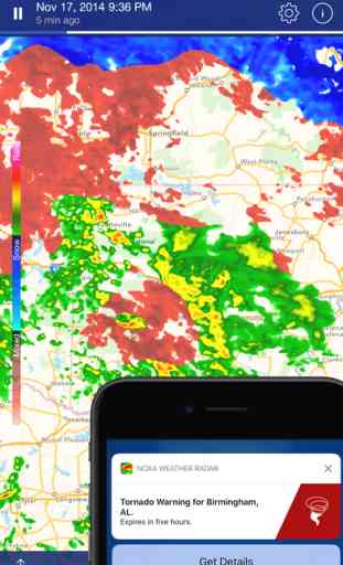
Radar and Satellite overlays show real-time rain, snow, mixed precipitation, and cloud cover in high resolution and vivid colors.
Rain map provides rain forecast for the range of next 24 hours right on the terrain map.
Push notifications - get warned whenever there’s a weather alert for your current location (tornadoes, flood warnings, snow storms, and more).
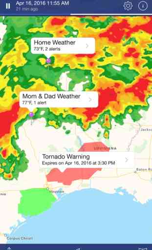
Weather alerts for any location. Access detailed alert information at one tap on the ticker bar.
The only app where all National Weather Service watches, warnings, and other alerts are shown on the map as interactive polygons covering the territories they're active for. Tap one to get the full alert text.
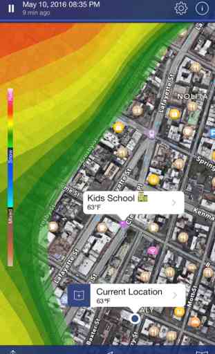
Snow depth map. Get local and global view of current snow layer.
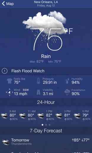
Detailed Weather info for locations includes current conditions, 24-hour and 7-day forecasts.
Features:
- Easy location search. Search by name, or just long tap any spot on the map to get detailed weather for it
- Bookmarks. Quickly switch between your favorite spots to see the weather there
- Background maps: standard, hybrid, satellite
- Choose animation speed, set opacity for radar and satellite overlays
- Precise weather data from the nearest meteo station
- 24-hour and 7-day weather forecast for any location you choose
- Current and "Feels Like" temperature. Today’s Min and Max
- Pressure, humidity, wind speed, and visibility details, dew point info
- Chance of Precipitation parameter will give you a heads-up about upcoming rain, hail, sleet, or snow days ahead before their landfall
- Sunrise & sunset time
Take your weather watching to the next level. Track the latest weather activity in smooth high-definition. See what weather is coming your way, and keep you and your family safe.
Coverage Info:
Radar images are available for the United States (Continental US, Alaska, Hawaii, and Puerto Rico), Canada, Australia, European Union (the United Kingdom, Ireland, Germany, France, the Netherlands, Belgium, Luxembourg, Liechtenstein, Switzerland, Italy (western), Denmark (southeast), Poland (western), Czech Republic, Austria (northwestern), Japan.
Rain map, satellite images and detailed weather info is available worldwide.
Hurricane tracker provides Pacific and Atlantic coverage.
NWS watches, warnings, advisories – the USA only.
Core Functionality:
Radar and Satellite overlays show real-time rain, snow, mixed precipitation, and cloud cover in high resolution and vivid colors.
Rain map provides rain forecast for the range of next 24 hours right on the terrain map.
Push notifications - get warned whenever there’s a weather alert for your current location (tornadoes, flood warnings, snow storms, and more).
Weather alerts for any location. Access detailed alert information at one tap on the ticker bar.
The only app where all National Weather Service watches, warnings, and other alerts are shown on the map as interactive polygons covering the territories they're active for. Tap one to get the full alert text.
Snow depth map. Get local and global view of current snow layer.
Detailed Weather info for locations includes current conditions, 24-hour and 7-day forecasts.
Features:
- Easy location search. Search by name, or just long tap any spot on the map to get detailed weather for it
- Bookmarks. Quickly switch between your favorite spots to see the weather there
- Background maps: standard, hybrid, satellite
- Choose animation speed, set opacity for radar and satellite overlays
- Precise weather data from the nearest meteo station
- 24-hour and 7-day weather forecast for any location you choose
- Current and "Feels Like" temperature. Today’s Min and Max
- Pressure, humidity, wind speed, and visibility details, dew point info
- Chance of Precipitation parameter will give you a heads-up about upcoming rain, hail, sleet, or snow days ahead before their landfall
- Sunrise & sunset time
Take your weather watching to the next level. Track the latest weather activity in smooth high-definition. See what weather is coming your way, and keep you and your family safe.
Coverage Info:
Radar images are available for the United States (Continental US, Alaska, Hawaii, and Puerto Rico), Canada, Australia, European Union (the United Kingdom, Ireland, Germany, France, the Netherlands, Belgium, Luxembourg, Liechtenstein, Switzerland, Italy (western), Denmark (southeast), Poland (western), Czech Republic, Austria (northwestern), Japan.
Rain map, satellite images and detailed weather info is available worldwide.
Hurricane tracker provides Pacific and Atlantic coverage.
NWS watches, warnings, advisories – the USA only.
Category : Weather
Related searches