GeoSpy AI Review: Powerful AI-Powered Image Geolocation Tool
Overview & Purpose

GeoSpy.ai is an AI-powered visual intelligence platform that analyzes pixel data from images to provide fast, metadata-free geolocation predictions worldwide. It leverages advanced computer vision models trained on millions of geotagged images to identify geographic features such as architecture, vegetation, soil, landmarks, lighting patterns, and terrain, delivering location estimates enriched through AI for high global accuracy—claimed up to meter-level precision in specialized deployments.
Primary use cases include law enforcement and government intelligence operations (e.g., locating suspects from low-context photos in seconds), OSINT investigations, journalistic photo verification to combat misinformation, developer integrations for automated workflows, and even personal or educational exploration of untagged images. The tool has reportedly helped solve over 10,000 cases worldwide, with real-world examples like apprehending fugitives rapidly.
Target audience primarily encompasses developers integrating the API into applications, OSINT professionals, investigators, journalists, law enforcement agencies, and qualified enterprise/government organizations. While early versions offered broader public access for casual users, the platform has evolved by 2025–2026 to focus on professional and institutional users requiring secure, high-stakes intelligence.

Key Features & Capabilities
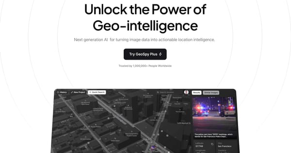
Core functionality involves uploading an image (or URL) via the web interface or API, after which the AI processes visual cues and returns predicted coordinates, a confidence score, an interactive map view, and breakdowns of contributing elements like building styles or vegetation.
Standout features that differentiate it from competitors (such as basic reverse image search or metadata-reliant tools like Picarta.ai) include its specialized training for pixel-only analysis across global environments, rapid results in seconds, support for batch processing and custom models in enterprise tiers, on-premise deployment options for sensitive data, and integration with tools like Google Maps for immediate verification. It handles challenging inputs like cropped, blurry, or indoor shots better than many alternatives in optimal scenarios.
Limitations include variable accuracy depending on image quality—excelling with distinctive urban or landmark-rich photos but struggling with generic landscapes, outdated scenes, heavy blur, or low-context interiors. No public unlimited free access exists anymore, and results are probabilistic predictions requiring human verification. Missing features for some users: fully open-source models or unlimited casual testing without approval.

User Experience
The web interface is clean, intuitive, and beginner-friendly, featuring a straightforward upload button, real-time processing indicators, and polished results pages with embedded maps and explanatory analysis—creating a minimal learning curve even for non-technical users. Developers appreciate the straightforward API for quick integration.
Documentation is developer-oriented with GitHub sample repositories for code examples and API references, though public details are limited compared to fully open platforms; support includes community resources (historically Discord) escalating to priority assistance for paid/enterprise users. Overall, the experience feels professional and efficient, with high-quality visuals and responsive design across devices.
Performance & Reliability
GeoSpy.ai stands out for exceptional speed, typically returning detailed geolocation results in just seconds even for complex analysis, making it highly efficient for time-sensitive workflows. Reliability shines in real-world high-stakes applications, with law enforcement reporting strong performance on actionable intelligence.
Known issues from user feedback and tests include occasional inaccuracies on non-distinctive or altered environments (e.g., mistaking similar coastal regions), leading to broader regional guesses rather than pinpoint coordinates. Common complaints center on privacy implications rather than technical failures, with no widespread reports of downtime or major bugs. Results should always be cross-verified, as the tool excels as a powerful starting clue rather than a standalone solution.
Pricing & Value
GeoSpy.ai follows a tiered structure with options suited to different scales:
- Free tier: Limited to approximately 20 images per month for approved testers (base model, community support).
- Scale/Developer plans: Higher volumes (e.g., 1,000+ images) starting around $60/month with priority features.
- Enterprise: Custom solutions with dedicated resources, on-premise options, custom models, and priority support—pricing via contact (tailored for government/law enforcement needs).
Value is strong for professionals where rapid, metadata-free geolocation delivers clear ROI, such as investigations or automated systems—outpacing slower manual OSINT or less precise alternatives. The free tier enables low-risk testing, while API scalability suits developers. For high-volume or security-focused users, enterprise options justify costs through proven case-solving impact, though casual individuals may find it less accessible post-2025 restrictions.
Practical Tutorial
A common task is geolocating a single photo via the web interface or API. Official samples and documentation are available on GitHub (https://github.com/Graylark-io/geospy-api-samples) and via API signup at api.geospy.ai (access by request).
Web Upload Walkthrough (Recommended Starting Point)
- Visit https://geospy.ai/ and select "Try Demo" (or log in if approved for full access).
- Prepare a clear, high-resolution image (JPG/PNG preferred; outdoor scenes with architecture or landmarks yield best results—avoid overly blurry or generic shots).
- Upload the file via the prominent button and optionally add context notes if prompted.
- Wait a few seconds for AI analysis (it scans for visual cues like terrain and structures).
- Review the output: predicted coordinates, interactive map pin, confidence indicators, and feature explanations (e.g., "Coastal vegetation suggesting Mediterranean region").
- Use integrated tools like "View on Google Maps" for verification or export the data.
Real example: Uploading a vacation photo of a distinctive Turkish coastal building often correctly identifies the city and nearby landmarks with high confidence.
API Integration Walkthrough (Python Example for Developers)
- Obtain API access and key by contacting support or signing up via the developer portal.
- Install dependencies:
pip install requests. - Use the following illustrative code (adapt from official GitHub Jupyter samples; endpoints and parameters may vary—check current docs):
import requests
import base64

api_key = "YOUR_API_KEY_HERE"
image_path = "path/to/your_photo.jpg"

with open(image_path, "rb") as f:
    image_base64 = base64.b64encode(f.read()).decode("utf-8")

headers = {"Authorization": f"Bearer {api_key}"}
payload = {"image": image_base64, "top_k": 3}  # Returns top predictions

response = requests.post("https://api.geospy.ai/predict", headers=headers, json=payload)
print(response.json())  # Example output: lat/long, confidence, location details
Test with sample images, handle errors (e.g., invalid key), and scale to batch processing for enterprise use. For full details and updates, refer to the GitHub repository or official support.
Final Verdict
Overall rating: 4.2/5
GeoSpy.ai excels for law enforcement, OSINT teams, journalists, and developers needing fast, AI-driven image geolocation in professional workflows, offering innovative pixel analysis and proven real-world impact. It is best suited for those who can verify results and afford enterprise tiers or qualify for access.
Avoid it if you need guaranteed pinpoint accuracy without cross-checking, prefer fully public/unrestricted tools, or have ethical concerns around privacy in non-investigative contexts.
One-sentence recommendation: If you're a qualified professional handling image-based intelligence, GeoSpy.ai is a powerful ally worth testing—its speed and depth make it stand out despite variable accuracy in edge cases.
(Note: Research conducted as of March 11, 2026; tools evolve rapidly—verify latest access, pricing, and features directly on the official site.)