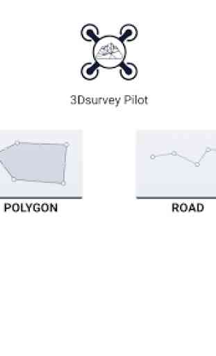
3Dsurvey Pilot
Post-flight processing of captured images is done easily with 3Dsurvey photogrammetry software, generating highly accurate, metric and geo-referenced results, such as dense point cloud, 3D mesh, topography map, elevation model, DSM, orthophoto. Perfect for any surveying professional.
Currently, the app supports the following drones:
• DJI
- Phantom 4 Pro V2
- Phantom 4 Pro
- Phantom 4
- Phantom 3 Professional
- Phantom 3 Advanced
- Mavic Air
- Mavic Pro
- Mavic 2 Pro
- Inspire 1 (Pro)
- Inspire 2
- Spark
Features and benefits:
- Plan your mission - flight plans for different needs
---GRID
Single Grid for mapping of rectangle areas - the fastest way for planning routes with simple settings
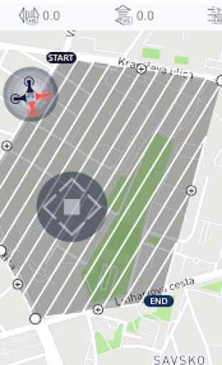
---POLYGON
Mapping of advanced/irregular shaped areas - additional area shapes and advanced settings
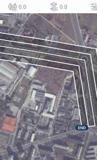
---ROAD
Developed specifically for simple and effective road, rail & corridor mapping
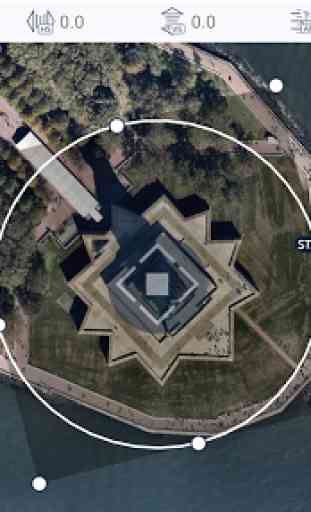
---CIRCLE
Circular mission for object mapping - always facing your point of interest for object 3D model reconstruction
- Automated drone flight & image acquisition
- Telemetry and live camera feed during the mission
- Simple workflow with 3Dsurvey's processing software
- Flight parameters for each mission - front & side image overlap, camera angle, flying height (AGL), flight speed - can be adjusted based on the requirements of the area and the project
- Advanced settings and options for demanding missions.
Post-flight processing & analysis using 3Dsurvey desktop software:
- Capture and recreate natural environment in digital form and survey from the office. Achieve high-resolution outputs with cm-grade accuracy.
- Use of Ground Control Points (GCPs) for improving the relative and absolute accuracy of the model
- Generate and modify:
--- Point clouds
--- Orthophotos
--- Digital 3D models (DSM, DTM, DEM)
--- CAD
--- Contour lines
--- Profiles and Cross sections
--- And more
- Measure:
--- Distances
--- Surfaces, Areas
--- Volumes
- Supports any drone & any camera/sensor. Works for aerial & terrestrial data acquisition methods. rTK- and EXIF GPS-ready for instant telemetry data import.
- 3Dsurvey is developed based on 300+ land surveying projects. Tailored to serve specific surveyors' needs. Cut fieldwork time by up to 100 times.
- Hybrid engine that utilizes both CPU and GPU for up to 15x faster image processing time. Large dataset support - 1000+ hi-res images.
- Compatible with third-party sources, data from LiDAR, Sonar, SLAM, terrestrial scanners. Seamless workflow for further combination with photogrammetric point clouds.
Usage information
Make sure you have the latest firmware installed and the app is up to date. The app follows the flight plan and does not avoid obstacles automatically.
3Dsurvey accepts no liability for damage, injuries or legalities from the misuse of this app. Use only in safe environments and follow your local drone regulation.
Category : Tools
Reviews (18)
very good, but there is not option to change RTH height, or change home point. I'd like also to upload my flight plan from pc because there are not actual ortophotos.
Licensed land surveyor in 2 states. This app is awesome and offers many great features for missions. Works seamlessly on Apple products but is glitchy on android.....
Crashes all the time, locks up my phone for periods of time, no terrain following option.
It just wasted 2 hours of my life and all my battery trying to make this stupid app fly my drone. It did the checklist, all cool and then it's "im stupid so can't take off, please restart me". Useless, avoid wasting your time
the application shut down during the flight, at the same time the drone engines shut down and crashed, shattered into parts. the drone was a phantom 4 pro, the phone is xiaomi pocofon f1 with android 10
Screen will only rotate one. Way due to phone buttons I can't sit my phone this way. Unusable and only app I've hsdthis issue with
haven't tried it yet but can't find the setting to change to imperial units... it's on the version from the iApp store...
Thats a good app but in android version flight time isnt correct.for example for mission in 2 ha calvulate 29 min by phqntom 4 pro for flight which it is impossible
It worked perfectly during the mission but shut down the app when I save the project
Will you update the android version, in IOS they can import kml, save the mission, load mission. Hopefully you stil develope the android version
Good, but needs the option of loading Polylines/way points with a kml
flight time estimates are too much longer than actual flights on Samsung S8 Plus with P4Pv2.
after update, the program fails and closes
Idk, I can't save my project from a kml files that has been changed in 3dsurvey. can u fix it?
App can't open in Android 12, note20 ultra
What desktop software should i use to load my survey?
When will there be an update for Mavic Air 2?
I'm having difficulties in the flight planning, because the software only takes photos on the edges of the turns. IE: if the software says it's gonna do 96 photos, in the end of the flight, I only have 15 photos. What can I be doing wrong? any help please???