Aero Ranger - DJI Mavic, Phantom4, Inpsire2, M200
Capture, tag and instantly live annotate aerial pictures of virtually anything with your DJI drone. Or use our companion app Aero Ranger X https://play.google.com/store/apps/details?id=requestdirect.com.arx.beta to capture images on the ground.
Back in the office or at home, view, manage and drag and drop to create reports from both Aero Ranger and Aero Ranger X in the Aero Ranger Cloud.
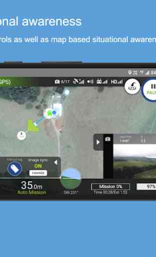
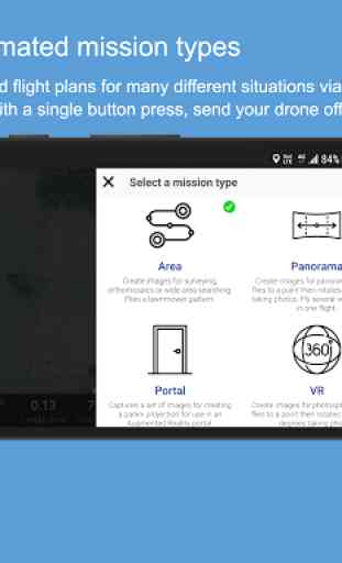
Not doing inspections? Aero Ranger also has many automated creative modes. You can capture photos to create an aerial Hyperlapse, capture 360/VR photospheres, capture houses for real estate advertising and create panoramas via repeatable missions with easy to use mission builders.
Aero Ranger is new and hence not perfect yet. Please go easy on us. We have many great new features and enhancements on the way. Please help us to make the apps better by sending your suggestions and bug reports to [email protected].
If you like what we are doing please give us 5 stars and help to spread the word online so that we can focus our time developing and improving the apps.
Please also join our Facebook Group at https://www.facebook.com/groups/aerorangerclub/
Supported drones: Mavic Pro, Mavic Air, Phantom 4, Phantom 4 Pro, Phantom 4 Advanced, M200, M210, Mavic 2 Pro, Mavic 2 Zoom, Inspire 2 (only tested with x4s camera)
Partly supported: M100, Inspire 1 (auto tag doesn't work with some camera models), Spark (waypoints not supported), Phantom 3 Pro and Advanced (not tested, but may work), M210 RTK (not tested), Mavic 2 Enterprise (no accessory control yet)
Not supported: Phantom 1, Phantom 2, Phantom 3 SE, Tello, XT2 Camera
Category : Photography
Reviews (28)
Congratulations to Aero Ranger. Very nice app indeed. I have used it several times now and it has performed flawlessly. It was rough (for me) to get going with it, but once I learned the layout and principles behind it, it worked as promised. I intend to use the app for photogrametry, which it is perfect for. Very nice work on this app!
Very good new app for DJI drones. Love the mode where the map follows the drone. Please could we have a line to home switchable on the map (unless it's there and I missed it)? Also a gauge to show remaining flight time, and the point at which low battery RTH will be invoked? Oh, and a 'find my drone' feature? Other than that I like it very much so far.
I understand this is geared towards industrial purposes, however from a filming point of view; able to repeat missions in exact orbits over period of time had led me to create some unique imagery, thank you team. Hopefully by next update we get more tools for film markers.... Cheers
Great work! A lot more intuitive than the native app from DJI and has all the functionality that I will need. You guys hit a home run!
Awesome app! The only thing missing is the ability to add additional waypoints after creating an orbit mission
Experienced thought went into making this Mission Building / Drone Flying software, can't wait to use it, other than adding some more macros (quickshots).... like "Whats a low yo-yo" look like and "Whats a high yo-yo" look like..... stuff like that would be cool.
Hi there, Could you elaborate a bit more about: - the possibilities of multiple battery missions? - the possibility to use offline maps?
Brilliant App! Makes the workflow for aerial survey quite smooth. EDIT: 3 Months on and i am still happy. this app is a credit to JB and his team.
Great in theory... Was never able to get a connection w/ my S10+ and wasted all my RC battery trying. Looks like no flying for me. Thanks for nothing.
YOU NEED TO ALSO INCLUDE PHANTOM3 SE. ! WHY BUILD SOFTWARE THAT ONLY WORKS WITH THIS BUT NOT THAT. THATS ALWAYS THE PROBLEM WITH SOFTWARE PEOPLE. OOOOO! A NEW GIZMO COMES OUT BUT FORGET ABOUT THE OLDER DEVICES THAT ARE PERFECTLY FINE BUT NOT "NEW"... I HAVE SEEN IT FOR DECADES WITH COMPUTERS. DRAFTING SOFTWARE RUNS JUST FINE ON A 256MB MACHINE BUT THEN A 5GIG MACHINE COMES OUT SO THEY DESIGN EVERYTHING FOR A 5GIG MACHINE FORCING YOU YO HAVE TO GO GET A NEW MACHINE JUST TP RUN THE SAME THING.
Waiting for email to change password, taken it out still no reset email. Not impressed.
Why does the app want to make and manage phone calls and without the permission it wont install?
Love this, easy to edit the flight path and waypoint
Does not connect to Mavic 2 Zoom using Samsung S7. Huge waste of time.
Crashes . Cant even open the app.
Would give it 4 or 5 stars but you guys dont have the mavic 2 pro and with that being said that exits me out in using this app which is a bummer cuz I think I would have like this app hopefully yall dropa update soon
best software i tried so far
cannot make a user id
Oh thanks thanks, team Aero Ranger Thanks ✌️✌️💪
Crashing on Android Q beta Please update
Love it!!!
Crashed my PS4 pro , side sensor warning didn't show....using S9+ also had a hard time connecting initially to the drone
Looks great so far. Would love to have a option to switch batteries in hyperlase mode, not possible yet afaik. Still figuring out other options but so far its good.
all sensor still working if mavic air use this apps? like using patrol mode?
I gave it a one can't get past the sign up don't have a way to get help to figure out why it wouldn't open.lets see if I get some help And I will change my ratting
Nice app. Has several mission modes not seen on many other apps.. Satellite maps work offline(!!!!!!), which puts this app ahead of DJI GO 4 and Litchi (for my device). Be careful when landing. It uses GPS to land, so it's not precise (allow up to 10m error margin). In order to exit the mission and manually land, push the pause button on your controller or put on into sports mode (doing either of these exits they mission).
So long DJIG4 and Litchi. I have full confidence in this app with my Mavic Air. Ran it out 9 miles to shoot a 247 pic 2 elevation building pano without a hitch.
Congratulations to the team. This is a great application one of the best if not the best I ve seen so far for intermediate to advanced users. I look forward to using it more and using its more advanced features. 1) This app is one of the greatest tools for an engineer or project manager of different kinds... e.g. in shipping, shipyards, buildings, farms, plots etc. OR simply for fun photos - videos during holiday etc 2) at the moment I have a DJI Mavic Air... which works very well with the app. Particularly impressed you can program and upload the data then drone takes off and executes mission, then returns to base. 3) This is app may be used for leisure to take videos from landscapes etc but its full potential is as described above i.e. engineers, project managers, inspections. I use the sure 4) The web interface is great. and the Mobile App too. BOTH have HUGE potential and with BETA feedback am sure both will improve soon.