Agroid GPS Area Measure
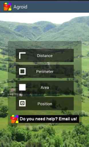
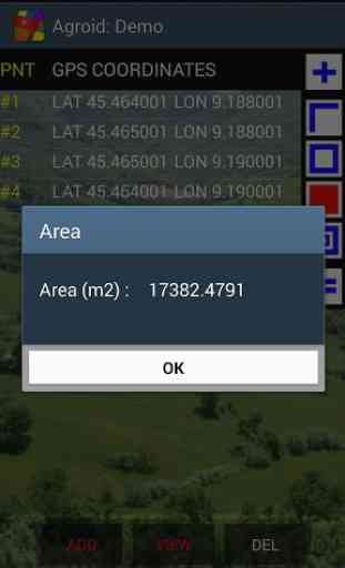
Agroid can measure distances, perimeters and areas (metric and imperial units for length and area): it is useful for measuring land, fields or buildings (app designed for a high OUTDOOR visibility).
Other unique usages:
- average altitude calculation (ellipsoid height)
- position error analysis (DRMS)
This free edition has a reduced download size and a minimal presence of advertising.
Using special functions such as ACCURACY SETTING and MARKER FINE REPOSITIONING you can improve the accuracy.
Maps can be downloaded in advance in order to avoid any internet connection during a survey .
Using the tracking mode you can collect points and measure by just walking around.
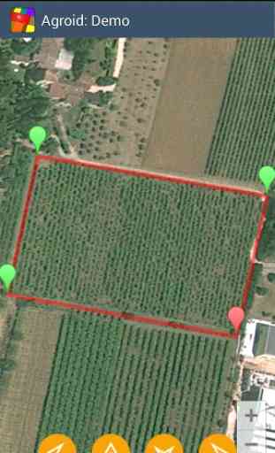
After the completion of the land survey you can access to the map views for viewing/repositioning your markers and export your data using KML or TXT files
Exporting the KML file you can view/trim the data in your favorite program
Tablet ready app: it supports Landscape/Portrait mode and pages are automatically resized.
Agroid has different operating modes:
- Survey mode (to measure without maps, GPS driven)
- Mixed mode (GPS & manual)
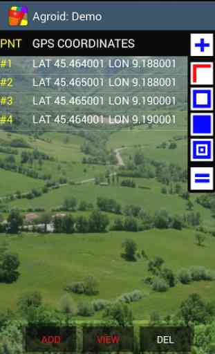
Coordinates can be retrieved from different sources:
- GPS (points collected according the specified accuracy)
- Tracking (GPS points collected according to specified rate/interval)
- Reference (manual input/edit)
Map providers:
- Google Maps (Satellite, Street, Hybrid, Terrain)
- Open Street Map (OSM)
Main geographical point functions:
- delete
- edit
- move
Main document functions:
- Maps
- Views
- Toolbar
- Zoom
- Select point
- File (New, Open, Save, Export, Delete)
- Share
Available measurements units:
- Length units: meter, feet
- Surface units: sq m, ha, sq feet, acres
Follow the automatic hints in order to use the app properly.
Read the embedded User Guide: read carefully the accuracy chapter to achieve the best results!
Other unique usages:
- average altitude calculation (ellipsoid height)
- position error analysis (DRMS)
This free edition has a reduced download size and a minimal presence of advertising.
Using special functions such as ACCURACY SETTING and MARKER FINE REPOSITIONING you can improve the accuracy.
Maps can be downloaded in advance in order to avoid any internet connection during a survey .
Using the tracking mode you can collect points and measure by just walking around.
After the completion of the land survey you can access to the map views for viewing/repositioning your markers and export your data using KML or TXT files
Exporting the KML file you can view/trim the data in your favorite program
Tablet ready app: it supports Landscape/Portrait mode and pages are automatically resized.
Agroid has different operating modes:
- Survey mode (to measure without maps, GPS driven)
- Mixed mode (GPS & manual)
Coordinates can be retrieved from different sources:
- GPS (points collected according the specified accuracy)
- Tracking (GPS points collected according to specified rate/interval)
- Reference (manual input/edit)
Map providers:
- Google Maps (Satellite, Street, Hybrid, Terrain)
- Open Street Map (OSM)
Main geographical point functions:
- delete
- edit
- move
Main document functions:
- Maps
- Views
- Toolbar
- Zoom
- Select point
- File (New, Open, Save, Export, Delete)
- Share
Available measurements units:
- Length units: meter, feet
- Surface units: sq m, ha, sq feet, acres
Follow the automatic hints in order to use the app properly.
Read the embedded User Guide: read carefully the accuracy chapter to achieve the best results!
Category : Tools
Related searches
Reviews (6)
kya. k.
Jun 24, 2014
thank
Ber. P.
Aug 26, 2014
more apps free.
Dil. O.
Sep 13, 2013
Stupid
Gre. V.
Jun 8, 2013
I uses this app to put up fields fence on my farm and it was amazing. The only improvements I would suggest is to be able to see where you are on the map while you are adding points and be able to take a photograph of each point. Perhaps even able to make / place a comment at each point. But then again it is free but I would pay $10.00 if it had those additional features.
Bob. B.
May 24, 2013
I guess I need to sit down and learn how to use this. The user screen isn't intuitive enough for me to learn how to use it without looking for instructions. I'll give it another try after doing some research.
Bad software useless