Agroid+ GPS Area Measure
Agroid Plus can measure distances, perimeters and areas (metric, imperial and Thai units for length and area): it is useful for measuring any planimetric element such as lands, fields or buildings (app designed for a high OUTDOOR visibility, no internet required).
If you are looking for more than a regular map ruler to measure areas, you have found it!
UNIQUE USAGES & FEATURES:
- average altitude calculation (ELLIPSOID HEIGHT)
- position error analysis (DRMS)
+ survey complete of geotagged PHOTOGRAPHS and NOTES
Using special functions such as AVERAGE GPS and MARKER FINE REPOSITIONING you can improve the accuracy.
Maps can be downloaded in advance in order to avoid any internet connection during a survey .
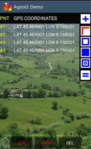
Using the tracking source you can collect points and measure by just walking around.
During your survey you can take PICTURES and insert MEMOS: miniatures of the geotagged photographs and notes can be displayed on a map or a list.
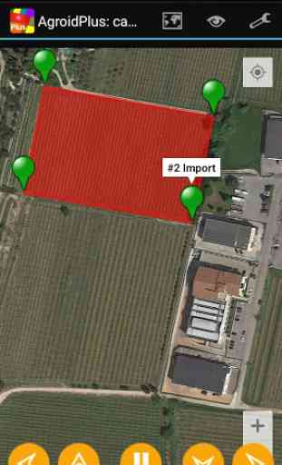
After the completion of the land survey you can access to the map views for viewing/repositioning your markers and export your data using KML or TXT files
Exporting the KML file you can view/trim the data in your favorite program
Tablet ready app: it supports Landscape/Portrait mode and pages are automatically resized.
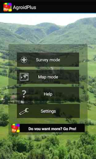
AgroidPro has different operating modes:
- Survey mode (to measure without maps, GPS driven)
+ Map mode (to measure with maps, Map driven, Android 3+)
+ Mixed mode (satellite & manual)
Coordinates can be retrieved from different sources:
- GPS (points collected according the specified accuracy)
+ Average GPS (average of points collected in the specified period)
- Tracking (satellite points collected according to specified rate/interval)
- Reference (lat/lon manual input)
+ Map center marker (lat/lon specified on the map)
+ Address (any postal address)
+ KML file import (any Point, Polyline, Polygon)
Map providers:
- Google Maps (Satellite, Street, Hybrid, Terrain)
- Open Street Map (OSM)
Coordinates can be viewed or shared with different standards (WGS 1984):
- Global Positioning System coordinates (EPSG:4326)
+ Web mercator coordinates (EPSG:3857)
+ UTM coordinates
Main geographical point functions:
- delete
- edit
- move
+ distance to next
+ angle
+ angle to next
+ add/edit note
+ add/edit picture
+ navigate to
Main document functions:
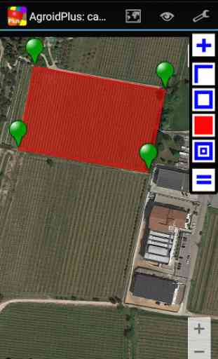
- Maps
- Views
- Toolbar
- Zoom
- Select point
- File (New, Open, Save, Export, Delete)
- Measure (Distance, Perimeter, Area)
- Share
Available measurements units:
+ Length units: meter, km, feet. yards, miles, wa
+ Surface units: sq m, sq km, ha, sq feet, sq yards, sq miles, acres, tarang wa, ngan, rai
Follow the automatic hints in order to use the app properly.
Read the embedded User Guide:read carefully the accuracy chapter to achieve the best results!
For any info or troubleshooting you can contact us at [email protected].
If you are looking for more than a regular map ruler to measure areas, you have found it!
UNIQUE USAGES & FEATURES:
- average altitude calculation (ELLIPSOID HEIGHT)
- position error analysis (DRMS)
+ survey complete of geotagged PHOTOGRAPHS and NOTES
Using special functions such as AVERAGE GPS and MARKER FINE REPOSITIONING you can improve the accuracy.
Maps can be downloaded in advance in order to avoid any internet connection during a survey .
Using the tracking source you can collect points and measure by just walking around.
During your survey you can take PICTURES and insert MEMOS: miniatures of the geotagged photographs and notes can be displayed on a map or a list.
After the completion of the land survey you can access to the map views for viewing/repositioning your markers and export your data using KML or TXT files
Exporting the KML file you can view/trim the data in your favorite program
Tablet ready app: it supports Landscape/Portrait mode and pages are automatically resized.
AgroidPro has different operating modes:
- Survey mode (to measure without maps, GPS driven)
+ Map mode (to measure with maps, Map driven, Android 3+)
+ Mixed mode (satellite & manual)
Coordinates can be retrieved from different sources:
- GPS (points collected according the specified accuracy)
+ Average GPS (average of points collected in the specified period)
- Tracking (satellite points collected according to specified rate/interval)
- Reference (lat/lon manual input)
+ Map center marker (lat/lon specified on the map)
+ Address (any postal address)
+ KML file import (any Point, Polyline, Polygon)
Map providers:
- Google Maps (Satellite, Street, Hybrid, Terrain)
- Open Street Map (OSM)
Coordinates can be viewed or shared with different standards (WGS 1984):
- Global Positioning System coordinates (EPSG:4326)
+ Web mercator coordinates (EPSG:3857)
+ UTM coordinates
Main geographical point functions:
- delete
- edit
- move
+ distance to next
+ angle
+ angle to next
+ add/edit note
+ add/edit picture
+ navigate to
Main document functions:
- Maps
- Views
- Toolbar
- Zoom
- Select point
- File (New, Open, Save, Export, Delete)
- Measure (Distance, Perimeter, Area)
- Share
Available measurements units:
+ Length units: meter, km, feet. yards, miles, wa
+ Surface units: sq m, sq km, ha, sq feet, sq yards, sq miles, acres, tarang wa, ngan, rai
Follow the automatic hints in order to use the app properly.
Read the embedded User Guide:read carefully the accuracy chapter to achieve the best results!
For any info or troubleshooting you can contact us at [email protected].
Category : Productivity
Related searches
Reviews (5)
dar. r. B.
Jul 13, 2018
Best Farmer apps ever
SUM. S.
Aug 9, 2014
How can i download previous version ?
rav. k.
Jan 19, 2014
Very good effective application useful to all surveay
ren. a.
Jan 11, 2014
Can we have the agroid pro for free..??
after paying for the pro version it will not work on my new phone rip off