AirMap
Additionally, AirMap is the provider of airspace maps to the FAA's Know Before You Fly Campaign.
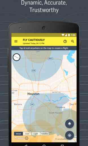
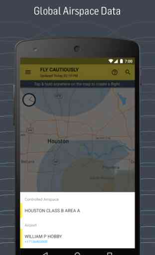
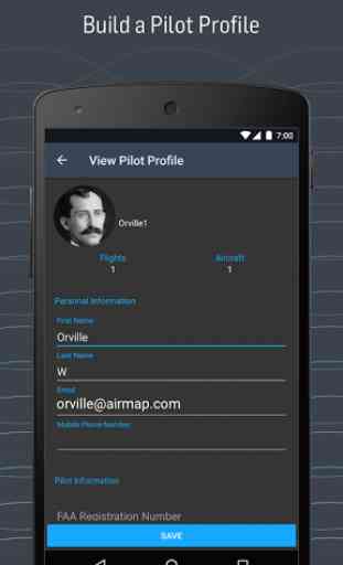
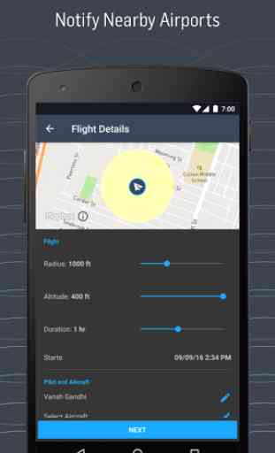
AirMap offers these features and more:
- View Airspace Data
- Toggle Airspace Information & Advisory Map Overlays
- Super Fast Vector Maps
- Pilot Profile View
- Manage UAV Aircraft
- Create & Manage Flights (incl. Future Flights)
- File Digital Flight Notifications (D-NAS)
- View Public Flights
- Toggle between Four Different Map Styles
- Search Map by Place or Location
Category : Tools
Reviews (23)
It's been days since Airmap stopped giving me any advisories whatsoever regardless of which point on the map I select. No advisories whatsoever, even if I select a point right on top of an airport or an Air Force base. It's still allows me to submit LAANC requests but what's the point if I have to use a different app anyway just to find out what advisories are in effect where I'll be flying?
As certified UAV pilos i can stay up to date on where I can LEGALLY fly. FAA's LAANC authorization is quick and easy for legal flights and you don't have to hold a Part 107 to get approval in most cases. Minimal to no ads. The interface shows a grid over restricted areas with max altitude for a specific grid.
1 Can not delete an aircraft once you add it. 2. Can NOT contact the Help/ support. The link goes to the Typeface website which is used to create the form, not to an email. 3. The mission type buttons (First Responder, AMA, Part 107 and Recreational) keep disappearing. 4. The "antenna" icon is for setting the date/ time of the flight- use a clock 5. There is no logical flow to using this app to check airspace, select the mission type, select the date/time, build a route, nor file
Good app for showing restricted zones and advisories. But one problem I keep encountering is it won't keep you signed in. Every time I open the app it asks me to sign in. Very annoying.
1. could not register; the app sent me in an endless loop of registration errors with no explanation of what is wrong. 2. there was no mention of LAANC that i could find anywhere! the maps were OK but very frustrating to navigate because it kept redirecting me back to the dysfunctional login screen. the instructions were almost nonexistent; laughably vague. i'm off to look for something better.
The inital install I did a few years ago was terrible and didn't work. The version that I am using now it so much better and smoother. More effective. Thank you for the continuing upgrades. Please, keep up the good work. The only thing that I wish would be for the FAA to revamp their list of Airports and remove some of the facilities that no longer exsist.
It seems like a good app and I like it compared to other apps I've tried since it tells you what the restricted areas are and it isn't completely full of ads. Also the recommended guidelines are very helpful. However, after downloading the FAA B4Ufly app, I realized that it doesn't show the restricted area around the helipads in my area.
i used this app in the past and loved all the information it provided and how you're able to create a flight plan. But after updating it i always get the "an error occurred while trying to complete the request. please try again. " error. Infact i haven't been able to create a single one yet. edit: i had to create a new account using a different email. i tried clearing cache, uninstalling then reinstalling, but nothing worked. even with the trouble it's a 5 star app.
Works great until you try to submit your application for a waiver. Then you get the message an unexpected error has occurred, try again. 2 different phones and the same thing both android. Airmap,I think that you have a problem! After reading the reviews, the developer has known about this issue for a while now but doesn't seem to be smart enough to fix the issue!
I don't usually write reviews, but this app is excellent. It allows you to actually fly in controlled airspace and makes the whole process extremely easy. Very well designed and intuitive. Thank you! I would appreciate different drone insurance options if possible like verifly.
I finally figured out LAANC on here. A bit more streamlined than UASidekick. Satellite mapping is not up to date though and that is difficult even landmarks are not there. Depending on updates instead of a dirt lot or building is just moved dirt. My ONLY other thing is chill out with the warnings. I don't need 20 alerts when most are the same. Thank you!
This app is great, so easy to use and understand. you can see exactly where you can fly or not and it provides numbers to contact local airports etc if needed. I've used it in multiple states and in some states you are even allowed to file your flight plan electronically.
Cant fault the app so far for what had been built in. Since 'Hover' stopped working on latest updates for Galaxy Note 10+ over had to look elsewhere, Airmap gives a lot of the same functionality. Features I'd love to see are offline maps (or tie into Here Maps for offline access) and other offline settings like cached weather or other reports for favourite areas
I am looking at your tutorials and they don't seem to match the app. I cannot figure out how the LAANC portion works. The screen caps on your website and the tutorial videos don't match up with the app. Additionally, it appears your using the inner boundary from sectional chart Class C airspace when it's the outer boundary that defines the airspace? When I do flight planning by hand with FAA sectional chart I get different results than with the app. I think this is a great app lots of promise. I hope these concerns can be figure out soon.
Although it's nice to have an app that shows NFZ and natural reservations, this app is inaccurate IMO, especially for some parts in Germany and Switzerland. I compared this map to official sources and it misses natural reservations (bird sanctuary) and the given NFZ of an airfield measures in the app a 5 km radius, although it should be 1.5 km. Not sure why some details differ from the official charts. map2fly and s.geo.admin are more accurate. This app may be useful for other countries, but I wo
Good app great map. Loads of good and important information here. It's just disappointing to see all the places you've ever wanted to fly are no fly zones. Bought a drone for mapping glaciers for a study, but they're all in national parks, so I guess this is how my research dieds.
Quick update: Airmap frequently loses my login data and I have to login over and over again through a webpage. Will be back to 5 stars once this gets fixed, but it's been ongoing for several months now. I use drones for research. One of my field sites is in controlled E2 airspace. Airmap allows me to do flights in that E2 airspace with instant automatic authorization. Perfect!
Just keep saying "internal server error" You guys need to fix this. Thanks
This is great App. Have very good and updated map, it will show you where you can fly your drone, however. I only used once and didn't check all features and options available, but still can give you good rate for the good and updated map.
EDIT: they fixed it. It was easy to use. My only reason for 4 stars is because of the message "Airspace authorization is either not available or not applicable to this flight" - well which is it? Because if it's "not available" then I don't want to be confused with "not applicable" and fly in unavailable airspace.
Would like to use this app, however every time I have my DJI Mavic Air controlller connected to my phone and powere on, when I attempt to create my Flight Plan on airmap, the entire app crashes. I've attempted to clear data and reinstall. No effect. Flight plan creates normally when not connected to a powered controller.
Each time I get through setting all the info for my flight, when I try to submit, I get get a generic "an error has occurred.". Then the app doesn't respond to the "next" button to try to redo it, so I have to force close the app and start over. And then I get that error again.
1. Agree with Jay Fisher, it won't keep you sign in. 2. Can't change email address. 3. Agree with Derrick L, can not delete an aircraft once added. It does have the potential of being a great app.