All-In-One Offline Maps +
Bored to wait for maps to display? Once displayed, maps are stored and remain available, quickly, even with no network access.
• Want more than just roads on your maps? You will find what you need here;
• Used to go to places with poor network coverage? Everything will stay available;
• Used to go abroad? You won't be lost anymore;
• Have a data allowance limit? It will reduce your usage.
This Plus version includes all features of the Standard version without ads, and supports import of professional GPS and geographic landmarks file formats (waypoints, routes, tracks, areas) like GPX, Google Earth KML/KMZ (map overlays not supported), OziExplorer WPT, CVS/TSV and Geocaching LOC
★
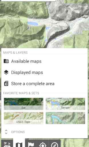
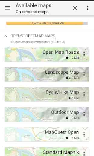
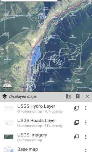
★ Maps ★★A lot of maps are available, including classical road maps, topographic maps, aerial (satellite) maps and various layers that can be added over any maps: OpenStreetMap (Roads, Topo), Google Maps, Bing Maps, USGS National Map (Hi-res topo, Aerial imagery), Worldwide Military Soviet topo maps, etc.
• All maps can be stacked in layers, with precise opacity control.
• Select and store large areas in few clicks.
• Stored space is clear and can be easily deleted.
★
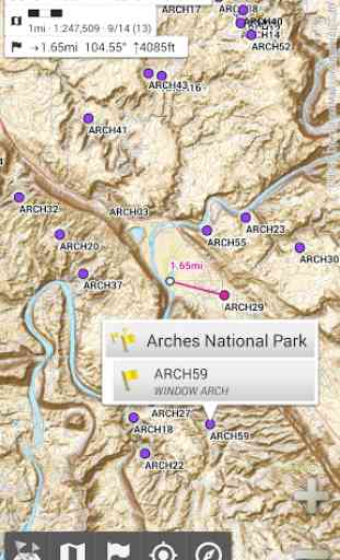
★ Display, store and retrieve unlimited landmarks ★★You can add various items on the map such as waypoints, icons, routes, areas and tracks.You can easily manage them using the powerful SD-Card Landmarks Explorer.
★
★ On-map GPS Localization & Orientation ★★Your real location and direction are clearly displayed on the map, which can be rotated to match your real orientation (depends on device capabilities).Easy turn on/off to save battery.
And also:
• Metric, imperial and hybrid distance units;
• GPS Latitude/Longitude and grid coordinate formats (UTM, MGRS, USNG, OSGB Grid, Irish Grid, Swiss Grid, Lambert Grids, DFCI Grid, QTH Maidenhead Locator System, ...);
• Ability to import hundreds of coordinate formats from http://www.spatialreference.org;
• On-map grids display;
• Full screen map view;
• Multi-touch zoom;
• ...
★
★ Need more? ★★If you are a real adventurer, try AlpineQuest GPS Hiking, the complete outdoor solution based on All-In-One OfflineMaps, loaded with a powerful GPS Location Tracker and more: http://www.alpinequest.net/google-play
Category : Travel & Local
Reviews (21)
Excellent control of map downloads. Simultaneous downloads of different layers from different sources, detects transmission errors & cues up transmission again. Can have satellite imagery showing vegetation, lakes & streams, with other overlay layers showing topographical contours, and place names. Can change display opacity of different layers. Your GPS position shows independent of mobile data off, & airplane mode on; no cell service required. All data storable to SD card. A private offline GPS on your phone! Setup waypoints & more!
Dinged a star for not showing release notes until after updating...
One of my favourite apps. Allows us to walk long distance routes (using gpx route uploads and offline map download), so it is incredibly easy to navigate. Not the most user friendly interface but you get used to it.
Best and easiest offline map I have found to date. I do lots of hill walking and use it all the time. Very battery friendly. I have it on my tablet and phone and I would recommend it to any avid map user or nubee user alike.
i have been using this app as backup for my garmin while cycle touring south east asia, Central America and North America. the only thing i would change is finer adjustent for downloading tiles and increasing the font for target distance.
The best & brightest in it's type category. With a very large variety of maps available; it is unmatched by any alleged competitors.
I love this app for plotting my kayak river runs. More often than not there's no service so I can plot at home, then update campsites as I go down the river.
Perfect, exactly what I wanted and wouldn't change a thing. Purchased app on android phone and now have iPhone. I cannot find the app on my iphone, is it available?
This app shows property lines on multiple layers. This worked great to mark my land for no hunting boundaries.
It's handy for roming the mountins where there is no reception. Just download the areas you plan to go befor you leave home.
This app is just what is needed if you go out in the wilderness where there is no good reception. Great tool.
I've been using this app for years, sometimes in preference to google maps.
best offline map. l am using it about a year and its perfect .
Very good application with great offline maps.
slightly different UI but good and solid maps
Great app. I used it for hiking in many places in the world
Great app does everything I need and at a reasonable costa
THIS GPS MAP WILL POSITIVELY LOCATE ME ANYTIME I HAVE THIS DEVICE WITH ME.
Just works. Need to learn how to use it though
hard to use
This is our " go to" app for our coastal shallow water navigation. Using choices from several satelite maps available we can easily pick our course through shallow water areas which other wise are not indicated with nautical charts. It will be even better if the developer ever gets to leave the "breadcrumb" trail in future improvements. Always 5 stars, many tnx from us.