AlpineQuest GPS Hiking
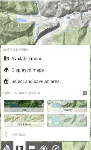
You can access and store locally a large range of on-line topographic maps, which will remain available even while being out of cell coverage. AlpineQuest also supports on-board file based maps, like MemoryMap(c) maps.
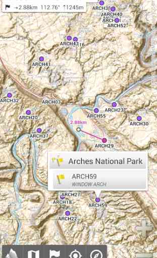
By using the GPS and the magnetic sensor of your device (with compass display), getting lost is part of the past: you are localized in real-time on the map, which can also be oriented to match where you are looking at.
Save and retrieve landmarks, share them with your friends. Track your path, get advanced statistics and interactive graphics. You won't have anymore questions about what you can accomplish.
By staying fully operational out of cell coverage (as often in mountain or abroad), AlpineQuest assists you in all your desires of deep wilderness exploring...
Don't hesitate, try the free Lite version right now!
PLEASE report suggestions and issues on our dedicated forum http://www.alpinequest.net/forum (no registration needed, all questions answered) and not in comments.
Key features are:
★
★ Maps ★★
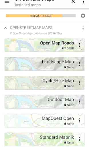
• Built-in online maps (with automatic local storage; road, topo and satellite maps included);
• Built-in online layers (road names and hills shading);
• Get more online maps and layers in one click from the included community map list (Nokia maps, Yahoo! Maps, local topo maps, ...);
• Complete area storage of online maps for off-line use;
• On-board offline maps support (visit our website to get the free map creator MOBAC);
• Memory-Map support (QuickChart .QCT maps only, .QC3 maps not compatible, test your maps using the free Lite version first);
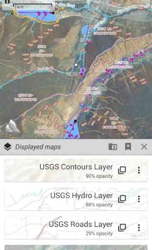
• Multiple maps in layers display, with per-map opacity control;
• Advanced SD memory card Map Explorer and Scanner.
★
★ Landmarks ★★
• Create, display, save, restore unlimited number of waypoints, routes, areas and tracks;
• Import/export GPX files, Google Earth KML/KMZ files, CSV/TSV files;
• Support OziExplorer WPT and Geocaching LOC waypoints;
• Save and share online locations with other users using Community Landmarks;
• Details, advanced statistics and interactive graphics on various items;
• Time Controller to replay time-tagged tracks;
• Routes, tracks and areas creator;
• Advanced SD memory card Landmarks Explorer.
★
★ GPS Position / Orientation ★★
• On-map geolocation using GPS or Network;
• Map orientation, compass and target finder;
• Built-in GPS/Barometric track recorder (long tracking capable, running in a separate and light process);
• Proximity alerts and leave path alerts;
• Barometer support (for compatible devices).
★
★ And more: ★★
• Metric, imperial and hybrid distance units;
• GPS Latitude/Longitude and grid coordinate formats (UTM, MGRS, USNG, OSGB, Irish Grid, Swiss Grid, Lambert Grids, DFCI Grid, QTH Maidenhead Locator System, ...);
• Ability to import hundreds of coordinate formats from http://www.spatialreference.org;
• On-map grids display;
• Full screen map view;
• Multi-touch zoom;
• ...
About the "Phone state and identity" Android permission: due to the backward compatibility of AlpineQuest with Android 1.5, this permission is automatically added by Google Play.
Category : Travel & Local
Reviews (19)
I found this app while looking for a replacement for Viewranger, which I've been using for many years. It is the best outdoor navigation app for Android bar none. Small, fast, and with an interface that is obviously designed by people that use it outdoors in anger on a daily basis. Highly recommended.
This app is a Swiss army knife. Take time to learn the documentation, play around with settings and features. This will be very rewarding. I use SAS.Planet which is free software for Windows to generate combo maps. Select area of interest. Levels down to z14 are Open Topo map, then z15 to 17 are satellite imagery. Save both into separate files in RMaps SQLite3 format. Then transfer the resulting *.sqlitedb files to my tablet... This makes perfect map solution for my hunting needs. Thank you!
Difficult since updates to find how to add in your own qct files. This had been enabled since 2019 but lost access recently. Found it in the end after an hour of messing. Used this app for years and always found it great on walks with the family or assisting students on DofE walks.
Brilliant !. Have used free version for years, just updated to paid version and tested yesterday, worth every penny. Another app refused to allow me to login rendering it useless. DONT ever bother using an app with a login , if something goes wrong you WONT even be able to access downloaded maps.
It's pretty cool. Plotting your course and seeing all the different maps you can get you can spend hours on this app just playing around. Easy and fun. Thanks.
This app just gets better and better. So much better featured and easier to use than my expensive old Garmin. Regular updates with new and improved data and interfaces. Excellent!
Great app, used it on some long trips out of network coverage, worked flawlessly. Take the time to learn what it can do, there are many useful features that are not immediately apparent. Well worth the price
Excellent map app. I have Memory Map but no longer use it on a computer. Making the MM files available to the AlpineQuest app means I can again use the MM maps. Very easy to use.
I love this app. Best GPS and maps you can get. I can download the maps that I want and be used for driving or hiking.
Superb app for navigation. I use it with old digital OS maps and record and save all my routes.
Great app! Really good variety of maps, with varying amounts of detail, depending on activity
It is the best useful app that I've ever seen in my life. Nothing can be comparable with this app. I convey my heartiest thanks to all members who gave their relentless efforts to make this app.
This is by far the best mapping app available. You can purchase features one by one so that you only pay for what you need. And it's not a subscription. If this app won't do it, it probably doesn't have anything with maps or navigation to do. I have used this app for terrestrial navigation for years, both in urban areas and wilderness. Even for boating, it can work like a dedicated plotter. And last but not least, the selection of free maps is unsurpassed.
Awesome! I'm a surveyor working in remote areas in the Pacific Northwest. I use AQ constantly when navigating forest roads and searching for old section corners. It is accurate (my Pixel4 gets some credit here, too...) and reliable and displays my agency's GIS layers with ease. The ability to work in State Plane grid coordinates is icing on the cake!
Great due to availability of different backgrounds, option to add custom background map (geopackage), add and switch on / off multiple gpx routes, etc
Best and most useful paid for app on android. Bought it years ago and use all the time.
Hands down the best navigation and mapping app I've used.
Great little app, I use it a lot when I go on walks. Shows all the footpaths.
A very useful app, especially if you plan to walk, climb or cycle outside the UK where paper mapping can leave a lot to be desired compared to OS. This review is based upon the previous version, I have not used " pro" yet in the field but one noticable improvement is that text on the maps, eg Street names or contour numbers, scale when zooming at a level which allows reading them more clearly on a phone, the font size before was very small.