AlpineQuest GPS Hiking (Lite)
You can access and store locally a large range of on-line topographic maps, which will remain available even while being out of cell coverage. AlpineQuest also supports on-board file based maps, like MemoryMap(c) maps.
By using the GPS and the magnetic sensor of your device (with compass display), getting lost is part of the past: you are localized in real-time on the map, which can also be oriented to match where you are looking at.
By staying fully operational out of cell coverage (as often in mountain or abroad), AlpineQuest assists you in all your desires of deep wilderness exploring...
Don't hesitate, use it right now for free!
PLEASE report suggestions and issues on our dedicated forum http://www.alpinequest.net/forum (no registration needed, all questions answered) and not in comments.
Key features (for the full/paid version) are:
★
★ Maps ★★
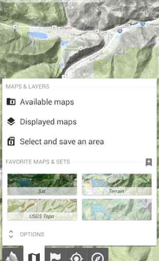
• Built-in online maps (with automatic local storage; road, topo and satellite maps included);
• Built-in online layers (road names and hills shading);
• Get more online maps and layers in one click from the included community map list (Nokia maps, Yahoo! Maps, local topo maps, ...);
• Complete area storage of online maps for off-line use;
• On-board offline maps support (visit our website to get the free map creator MOBAC);
• Memory-Map support (QuickChart .QCT maps only, .QC3 maps not compatible, test your maps using the free Lite version first);
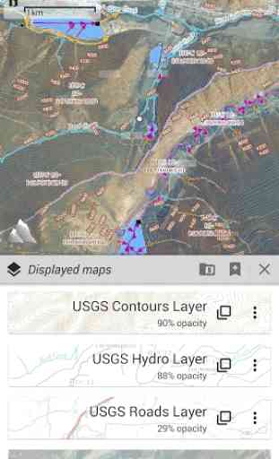
• Multiple maps in layers display, with per-map opacity control;
• Advanced SD memory card Map Explorer and Scanner.
★
★ Landmarks ★★
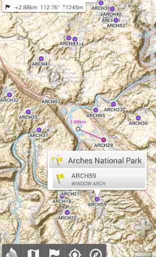
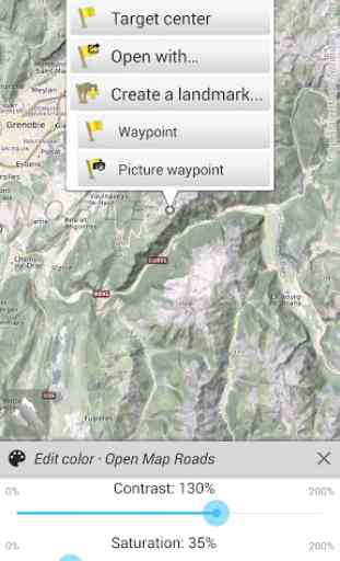
• Create, display, save, restore unlimited number of waypoints, routes, areas and tracks;
• Import/export GPX files, Google Earth KML/KMZ files, CSV/TSV files;
• Support OziExplorer WPT and Geocaching LOC waypoints;
• Save and share online locations with other users using Community Landmarks;
• Details, advanced statistics and interactive graphics on various items;
• Time Controller to replay time-tagged tracks;
• Routes, tracks and areas creator;
• Advanced SD memory card Landmarks Explorer.
★
★ GPS Position / Orientation ★★
• On-map geolocation using GPS or Network;
• Map orientation, compass and target finder;
• Built-in GPS/Barometric track recorder (long tracking capable, running in a separate and light process);
• Proximity alerts and leave path alerts;
• Barometer support (for compatible devices).
★
★ And more: ★★
• Metric, imperial and hybrid distance units;
• GPS Latitude/Longitude and grid coordinate formats (UTM, MGRS, USNG, OSGB, Irish Grid, Swiss Grid, Lambert Grids, DFCI Grid, QTH Maidenhead Locator System, ...);
• Ability to import hundreds of coordinate formats from http://www.spatialreference.org;
• On-map grids display;
• Full screen map view;
• Multi-touch zoom;
• ...
About the "Phone state and identity" Android permission: due to the backward compatibility of AlpineQuest with Android 1.5, this permission is automatically added by Google Play.
Category : Travel & Local
Reviews (24)
Best outdoor navigation app GAIA is pretty good and has more maps available (but that doesn't mean you can use all of them offline). But Alpine is lightweight and does everything you need. Buy the pro version and you can download maps for offline use. Pro version ships with basic maps. USGS Sattelite (meh, OK), USGS Topo, and some others. You can load GPS files onto this. TIP: Check out the windows program MOBAC for generating offline maps to use with this app. Highlyrecommend! !
I found this application is very useful .. it helped me in my work for locating coordinates and find them very easy
This is perhaps the best app for a hiker available in the market. I only found one problem during navigation. If the screen turns off for about 10 seconds, and you turn it on again, the GPS freezes in the last position. That is rather annoying. I tried letting work in the background, auto on, remove the battery saver. I could not solve the problem. Could it be possible to adapt the program in such a way that if the GPS slider is active, the program reactivates the GPS any time the screen is on?
Having tested and explored this "lite" version, the paid pro app would seem to be the perfect replacement for Viewranger. It's far better, in fact. The single glaring problem is how to get UK Ordnance Survey Maps; but it *is* possible.
very easy to use and the trails I hiked are all accurate enough for me
Best app for trekking/ hiking,hiked across France and Spain with alpine quest as guide
Hi, I have tested this program with Ethernet turned off and in a place without network. It displays excellently and remembers all the specifications. You can be comfortable when this program is in your pocket.
I always navigated in mountains with maps, but now I am using this amazing application, and leave map and compass as back up. It works perfect even in bad weather and fog. I recommend this useful hiking application.
Good and reliable apps
i haven't had a chance to utilize this map app in an outdoor environment, by downloading topo maps..But as far as it's operation and accuracy within my town, it works great. Thanks..
I don't like that I have to turn the phone off to get out of the app. The app navigation buttons are over the android home screen, back page, and open apps buttons.
Very nice app. As a beginner I have a question: how to save my map including routes and check points on my SD card to be able to reuse them in case I uninstalled the app or formatted my Android device.
Amazing! This app is very useful when doing outdoor adventure. We had a camping at an unfamiliar island in Philippins, and we were able to explore beautiful sites through AlpineQuest!
Great application with a good choice of freely available maps. Have used it for hiking in New Zealand, Iceland, US, various countries in Africa and Europe.
Useless. This app could serve as a demonstration of how to put users off and ensure they do not buy the paid version. Every time I try to load one of my maps, it says 'This feature is not available in the free version.' So I have no idea how they would display.
Great app! Very useful for hiking - it shows all tourist trails and helps to find the right direction.
That's great. But it would greater if it gave us the exact distance between the two spots (other than the straight ruler!) 🙏 💗
Fantastic app. I am hopeless in reading maps but feel safe to walk wherever I want as I can always find my way back.
this good applications for offline navigation. we would appreciate if u add feature for route example. turn by turn navigation
The light version works well. Will consider purchasing the full version. Now have the full version. Brilliant will be trying OS .
Wonderful app. The only app map I use. Thank good. Bless you. Best in the world! Keep your memory maps. This is far more comprehensive
Best app for hiking!! It really saved my life on a hike. Accurate and flexible. It's like 5 apps in 1.
Awesome app, very accurate and stable. Works brilliantly with .qct OS maps. A hikers best tool by far!
I found this app while looking for a replacement for Viewranger, which I've been using for many years. It is the best outdoor navigation app for Android bar none. Small, fast, and with an interface that is obviously designed by people that use it outdoors in anger on a daily basis. Highly recommended and the Pro version is well worth your money.