
ANWB Waterkaarten
- Locations of marinas and all information on marina facilities.
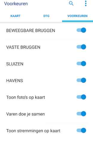
- Data on waterways.
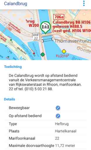
- Opening of locks and bridges.
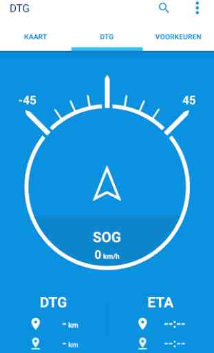
- Enter a destination and read directly off the sailing direction, DTG, ETA and SOG.
- All data offline, no data connection required during operation.
- Cruising stoppages Rijkswaterstaat
- Nodes "Safe Sailing"
- A photo and / or make a note on location and add to the water mapSubscriptionThe app only works with a valid subscription. The first two days of use is free. You can subscribe to:
- One week (€ 4.49)
- One month (€ 9.99)
- One year (€ 38.99)The subscription will automatically stop.Note: If you have a subscription within the trial period of two days, will be canceled the remaining trial period.payment plan
- The payment of the subscription takes place via your Google Account.
- Refund of an amount already paid during the active subscription period is not possible.Additional informationThis app contains all the navigation charts of the ANWB, combined with data from waterways, bridges, locks and marina facilities. The nautical charts are identical to the paper nautical charts of the ANWB. They have updated two-year cycle, each year half of all cards is renewed. If you subscribe for one year, at least once will be offered an update of the data. You sail always with the most current data from the ANWB!Note: Download this app only with a WiFi connection. Download Size approximately 1.4 GB.Note: Prolonged use of GPS running in the background can dramatically decrease battery life.about AAThe Royal Dutch Touring Club ANWB is an association with a unique blend of influencing and service activities the interests of its members represents in terms of mobility, travel and leisure. When that work is the ANWB wants to contribute to the sustainable development of society.
AbonnementDe app werkt alleen met een geldig abonnement. De eerste twee dagen gebruik is gratis. Je kunt een abonnement afsluiten voor:- Een week (€ 4,49)- Een maand (€ 9,99)- Een jaar (€ 38,99)Het abonnement stopt automatisch.Let op: Als je binnen de proefperiode van twee dagen een abonnement afsluit, komt de resterende proefperiode te vervallen.
Betaling abonnement- De betaling van het abonnement vindt plaats via je Google-account. - Restitutie van een reeds betaald bedrag tijdens de actieve abonnementsperiode is niet mogelijk.
Aanvullende informatieDeze app bevat alle waterkaarten van de ANWB, gecombineerd met gegevens van vaarwegen, bruggen, sluizen en jachthavenvoorzieningen. De waterkaarten zijn gelijk aan de papieren waterkaarten van de ANWB. Ze hebben een updatecyclus van twee jaar, ieder jaar wordt de helft van alle kaarten vernieuwd. Als je een abonnement afsluit vo
Category : Travel & Local
Reviews (17)
Fantastic app for sailing or boating in the Netherlands and hopefully soon Belgium, France, Germany, Denmark - it provides all information like bridge opening times, issues, overview, special regulations - one stop map - only thing I use - one minor thing is name in Netherlands is Waterkaarten app and when you have English android app setting is hard to find...
Used to be an ok app when one could get a single day subscription. Now, the minimum is one month. I can buy a paper map for that amount and use google maps on the side for free.
On my samsung galaxy s6 the app froze every single time I zoom in or move the map. Tried downloading a map, didnt solve the problem. Tried abot 6 times then gave up.
A really useful app. Particularly the ability to set up the height clearance of the boat to see if it will pass under bridges . Also the full marina and yacht harbour information.
Non functional routing basicly the map and info of almanac part 2. No live warnings of issues like blocked waterways etc.
This app says it is crashing and crashing. How can I fix this?
Yet another app that forces you to create an account to even try it.
has improved a lot in over the year
I need english and Australian water ways
Cant move from Spain
Cannot find the 7 days trial.
It is a great programme and invaluable when using the inland waterways. It gives you all the information you need and I used it extensively last year.
First impressions not great, particularly if you are English. You can select English language but the help screen is still in Dutch. I have emailed the developer on this but no reply. When you tap on a symbol for, say,, a bridge, a popup window gives text details but this is in Dutch too. The "legend" page does not include all of the chart symbols.
Opening times are not correct
App crashes whenever I use the almanac. In ben niet tevreden.
LisabethDixon Save
Been using this app for three years and it just keeps improving. The team behind the app are very responsive to feedback and always keep users informed. The automatic routing upgrade still in Beta shows promise but needs more work.