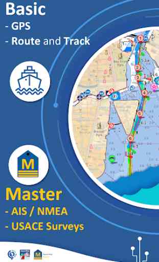
Aqua Map Marine - Boating GPS
►► Features:
• Download the maps on the device for offline usage
• Plan and navigate your ROUTE with real-time information on next waypoint
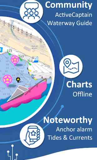
• Anchor alarm with advanced configuration
• Tides & Currents prediction and simulation
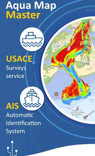
• Overlay the USACE surveys on top of your charts
• Share and load tracks, markers and routes (KMZ and GPX)
• ActiveCaptain & Waterway Guide community integration
• Connect your NMEA devices through WiFi
• Powerful search with advanced settings
• Display AIS info from external devices with automatic collision detection
• Expand your horizons with mapXpan (patent pending)
• Overlay the Satellite images on your map
• Measure distances on the map
• Query map objects at your finger tip
► MAPS
Aqua Map uses only official Nautical charts with depth contours, buoys, lights, etc. to enjoy the best boating experience. You can download the maps at home within your device and use them on the boat offline (no more Internet connection required). Our charts are derived in part from material obtained from: NOAA, CHS, BA, BSH, IIM, CNIG, AHS, NLHO, Explorer, etc.
Available areas: US, Canada, Bahamas, Caribbean, Bermuda, Brazil, Argentina, UK, Ireland, France Med, Spain, Portugal, Italy, France Med, Germany, Netherlands, Belgium, Croatia, Estonia, Malta, Australia, New Zealand, Seychelles, Maldives, Emirates, South Africa.
► ROUTES and WAYPOINTS
Plan your trip, insert and edit waypoints. Navigate your route and monitor distance, time (ETA) and direction toward your next waypoint or your final destination.
► ANCHOR ALARM
This function will check in realtime your GPS position against your anchor position previously defined. An acoustic and visual alarm will run as soon as your GPS position is out of the preferred range.
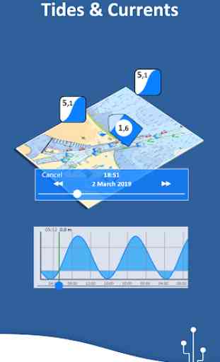
► TIDES & CURRENTS
You can calculate the prediction for more than 6800 stations in the US & Canada. You can also have a simulation of the T&C trend on the map.
► LOADING and SHARING
You can share your favorite's markers or send an email with your last daily track. Not only, you can also load any KML, KMZ, GPX (also zipped) found in internet or received from your friends.
► ActiveCaptain
Join the community of more than 100.000 boaters who write reviews, update data and provide up to date hazard information.
Read and contribute reviews and rating about marinas, shared local boating knowledge, anchorage and hazards
► Waterway Guide
Marinas, hazards, anchorages, bridges, free docks and much more to cover the entire US coastline.
► Aqua Map Master
With this subscription you will access a set of advanced functions that will transform your device in a real ChartPlotter (.. and more).
Connect your NMEA devices through the WiFi and use their data for all the App functions (eg Anchor Alarm), download and display the last USACE surveys, display the AIS targets on the map with automatic collision detection.
► TYPE OF PURCHASES
- Unlimited: you can download and update your charts forever.
- Subscription: it is a one year auto-renewable subscription, it will automatically renews unless auto-renew is turned off at least 24-hours before the end of the current period. Subscriptions may be managed by the user and auto-renewal may be turned off by going to the user's Account Settings after purchase.
For more information please visit our website www.globalaquamaps.com
or send us an e-mail at [email protected]
Category : Maps & Navigation
Reviews (29)
We use as backup for electronics in case of catastrophic failure. The app does shut down often but isn't a major problem since its just a redundancy and I am able to get it back up quickly. Also, I cannot use the anchor alarm off boat because I do not have advance settings. Not the end of the world. Otherwise, I really love this app. Use it every single day.
As a follow up on previous post: The app seems to have stabilized and now loads up and holds onto downloaded charts. It has not crashed again. Have yet to try out on water. If it works as advertised, will be a 5+.
Was great before but the new weather updates and overlays are fantastic. Instead of searching multiple sites for information, I now go to the Aqua Map Marine and just about everything I need for planning is there. The data is laid out in extremely easy to use and understand format.
Since last summer, I started to evaluate a few navigation apps to replace the one I used but is no longer supported. I decided to try Aqua Map (free trial) because it has all the features (packed!) that I want and the subscription for the maps is quite reasonable. I also noticed that they update/improve their product on a regular basis and the support has been great and quick via support email. I plan on using their Aqua Map master add-on. Really happy I found this one.
When viewing a small area (large scale) charts the distance unit is only in feet and can't be changed. I work in nautical miles and metres. I contacted the developer and received a quick response but they were dismissive of my feature request / bug report. 28 12 2021 No progress on being able to display short distances in metres. Rotating the tablet to horizontal causes some of the info boxes to overlay each other. Uping my rating to 4 stars as it is a very good app the above bugs excepted
Good to use pretty easy. But trying to figure out if it can plan a route and keep boat moving with screen. I have to manually move screen to keep up .
Great app for boating with fantastic customer support! I'm glad we each have it. Once we became familiar with the way it works, we use it constantly.
Exceptional App, best customer service response. The USACE overlays & frequent updates is one of best (of many) features of this app. Emails to customer service & responded to every single time quickly.
Terrible download interface based on tiles. One tile is 190MB in size, download breaked up 10 times - after downloading about 100MB, then restarts from the beginning, basically eating up 1GB of my data plan, costs me a fortune on data to get a single tile of the Bahamas. Does not continue where it stopped downloading. Useless if you not have an unlimited data plan.
I've just started using the product (mostly because they offer Bahamas Explorer Charts) so I can't provide a full review. But what I've seen so far has been excellent, and maybe more importantly the email support I've recieved from Enrico has been fantastic. He was able to walk me through some random issues with my tablet settings, which were not really related to the map software. His responses were quick and concise and got me through a problem of opening zip files. THANKS ENRICO!
Using it on both Android and IOS. Stable, fast, no crashes. As far as interface, usability, and speeed beats my 8k Garmin setup by a margin. I love the satellite image overlay where I can actually see shore structures and know exactly which bend I am passing. After spending my whole life in IT, I am a very tough reviewer from a coding perspective, however the app professionally written and interface is well thought out. Certainly one of the few that looks to be written by real coders.
Nice app, but when using routes it crashes on Android tablet and phone.
6/11/2020: Previously, I dinged this app for its crippled Android version and the weak GEC or Terra (Aqua) Map online editor. I'm pleased to report that the 'Master' version is now available on Android with the same low annual subscription as iPad, and the maps have been revamped so that the performance as a chartplotter on mobile devices is significantly improved. The new map format does require a complete reloading of all charts, but no additional fee was required for this download. While we'll always have a backup nav capability onboard, I would now trust this app to be our sole or primary navigation tool to navigate our trawler in the Chesapeake Bay and its tributaries, if needed. The GEC or Terra (Aqua) Map online editor integration with the app is now much better. There's still a steep learning curve, and it's not as intuitive as the online Navionics capability, but it appears the authors are trying to improve the experience. The app connects to our wireless network which is a bridge to our NMEA-0183 network and shows our AIS device and AIS targets as well as other data available on the NMEA network. We're using the app on a 2-year old iPad and a new Samsung Galaxy S6/32G.
I purchased the app and the more expensive Navionics and Explorer charts. A single license allowed Android and iPad versions to be used. The Android app re-drew too slowly to be useful but the iPad app worked well. The charts need to be re-downloaded due to an app but. I have to repurchase them again. There should not be a permanent chart price if the developers can change the app and obsolete your purchases.
I purchased USA maps and Aquamap Master using my phone today. This purchase will not transfer to my tablet which is what I use and so I've wasted my money. The charts also seem to be a mixture of the good vector and badly scalable raster version which are available free from NOAA. It's a surprise as to which is which until purchase, by then it's too late. The app still seems very beta considering my issues and so I would suggest avoiding until now usable and I've emailed for a refund
Easy to use but it a little lag and landscape view you lost you coordinate and knots
I have been using this as our main chart for sailing the bahamas over the last year. It is far more accurate than our raymarine chartplotter! I would highly recommend it. Recently I contacted customer service to assist installing it on a second device(my phone) and Pietro was great! He responded to the email within minutes, gave clear and good direction, and got me up and running.
The charts are great. But the crashes and stability is absolutely terrible. Many features do not work properly. Now i cannot even open the app because it crashes before it opens
Great ap ...... but crashes immediately trying to open in Android. There have been a few attempts to 'fix..... so far without success. Very responsive - just can't seem to find fix. Once fixed- it is a 5 Star App
This is a great app. I have it on my iPad as well as Samsung Galaxy 9+. I use the iPad at the helm with my older Garmin chartplotter. I find the perspective view incredibly helpful. On our latest trip thru the ICW and into the Albemarle Sound, I used the Route Explorer to predict time to bridges/marinas/anchorages and final destinations. This functionality is very valuable. I have also been able to display my depth via NMEA 0183 to my Vesper which connects to Aqua Map to also display AIS information. Charts can be updated easily and repetitively. Plus they can include USACE depth data and USCG Notice to Mariners (and also Active Captain and Waterway Guide)... Pietro and staff are amazingly responsive to requests for support. This app is so worth the small price it costs! If you have priced what the upgraded Garmin charts cost, you'll realize that Aqua Map is a phenomenal bargain.
Charts look great but whenever I try to search for something, the app crashes. Edited: developer was responsive. After sever reinstalls I haven't been able to reproduce the problem.
Recently got the App for a backup to my Garmin MFD and find it to be very user friendly. With Active Captain and USACE chart updates this makes cruising the shallows on the ICW a much more relaxing trip. Had some questions adding the maps to additional devices and their customer support was excellent; and fast...
If you're a Canadian on the great lakes, do not purchase this app. It's a frankenmap lacking important details... like the depths of harbours. It's completely obscured. It was supposed to be fixed 4 months ago but it was not. I'd ask for my money back if getting results actually worked. I was contacted by the dev with promised to fix the problem, which was acknowledged, to no avail. This app will ground you, and not in a good way.
Way to slow. Plenty of useful info but everytime you move the map you have to wait for everything to reload. Very frustrating when trying to plan a trip.
Was having crashes regularly. More stable now. Useful app.
still learning how to use this app, but it is working out very well. It would be nice if the app could be installed onto an SD card. it consumes a lot of memory oh, and that makes it hard for someone with an older phone.
Installed on Samsung E Tablet BUT trying to load a gpx file locks the program and you have to reinstall the software. Perhaps the The Samsung tablet is the problem but it works just fine with Navionics mobile app.
Application asks to go to google play to download the map areas. But there is no relevant areas to download on google play. So the application is useless in Europe and more areas... Why these things are always complex and hard to find... Make it simple to get it done.
Update from previous negative review. As I said, Great App. Works well and extremely useful. Problems with auto-renewal took quite a bit of effort by AquaMap to resolve, but it did get fully taken care of. I still think the idea of waiting until literally the last day to auto-renew an annual subscription is asking for problems. Lots of things can happen. At least a week or even a month would be better.