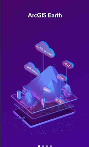
ArcGIS Earth
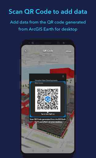
Add data from the QR code generated from ArcGIS Earth for desktop. Supported data types are as follows:
- ArcGIS services
- Portal items
- Web scenes
Enhanced the zoom to algorithm
Enhanced the Tour feature performance
ArcGIS Earth is a native application, available on iOS, Android and Windows platforms. It enables users to access content, tools, and analysis from anywhere, whether it's online or offline. ArcGIS Earth is designed for everyone and brings user-friendly 3D experiences right to your fingertips. It's also consistent between the desktop and mobile environments and adaptable to many collaborative scenarios.
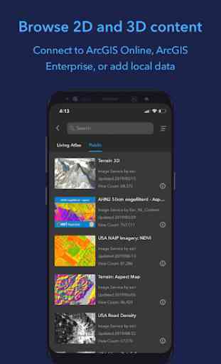
Data Support
- Browse web scenes, map services, image services, scene services, and feature services
-Browse local files including mobile scene packages (MSPK), KML, KMZ, tile packages and scene layer packages (SLPK)
- Support Living Atlas
Key Features
- Connect to ArcGIS Online or ArcGIS Enterprise
- Tap to identify feature
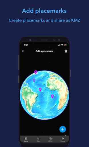
- Support collect, edit, and share placemarks
- Interactive analysis tools – Measure, Line of Sight, Viewshed
- Create and share tour with geotagged photos
- Search for places and switch locators
- Locate to your location
- Startup tips and hand gestures guidance
Category : Productivity
Reviews (28)
It's useless. It's such slow, and always laggy, and tools don't even work correctly. All that can be said about this is that it uses the crappy bing api and has 3d graphics dedicated for terrain only, and resolution is terrible compared to that of Google. Where are those 3d buildings shown in the thumbnail huh? Pretty sure this can't be better when it doesn't even have it's own api, no doubt for it to ever have more than 4 star ratings.
I have tried other GIS apps, found this one to be the most polished amongst them, with good enough tools. But if I try to load any layer from the portal it is taking me to a web login page, even though I am logged in the app, and fails to load any layer. This could easily have been a six star app, no doubt.
can't find anything about being open source, that's only a "licensed for developers use only" warning on the top, and it looks like esri only has proprietary software. much to the opposite of what i was hoping for and what i know it's the only way forward for the world. seem to be well since otherwise, but i can't bother to try it with these conditions. ~cregox
I just installed this app in order to view trail map in kmz format...the file is not being loaded when I browse it using ' Add Files'. Not sure what's wrong as there is no message about anything. There is simply no action. Please let me know if I am taking incorrect action.
Nice experience to have it in phone. There was a delay in getting the placematk renamed. It somewhat appears a little slow most of the time. Hope it will be fixed in next updates.
Tried to open a kml file... it gives off an error, "Fail to load". As such, it's useless if the user wants to open a file. Otherwise, plenty of display options.
I know that this app has a lot of cool tools for mapping and other, but nothing will show up on the map portion. It is just a black screen. How am I suppost to use this app as a tool when I cant see anything on it?
Long time ESRI user, decent app however I expected alot more. In particular theres no option for different coordinate systems, for instance MGRS. It's been 2 years since someone brought this up and still no fix.
Beautiful idea and design.. Moreover, biblical maps, ancient and maybe more of antiques maps. Overall great app for a start.
Worked for 5 minutes and now it keeps crashing. I also tried to upload a KMZ file, which it supports but the layer never appeared
Sir few month back you had better and latest clarity map than google earth, but what happened? Now your map clarity has taken out.. We kindly request you to grant us your clarity map.. Thank you sir
This app seems to work flawlessly on the iPhone, but every local file I try to load says "Failed to Load" no matter how I try to bring it in. Every file type I have tried, KMZ, KML, SLPK. Wish it worked on Android...
Data constantly fails to load. It also tells me that data roaming is turn on when in reality my data roaming is turned off. Running this app on Andriod A20
LKS Maps does not load up. Please fix! Also, Your app does not understand coordinates in the search! Please add this feature
Good Google Earth alternative. Especially useful for satellite images.
Used to be good... but then stopoed. Had to uninstall/reinstall, which seems to have worked.
Thanx for what help can be offered in these endeavors, eye love maps.
It crashes as soon as I get through the tutorial. I wish I could try it.
worst and outdated app for god sake update the recent imagery its showing 2018 data billions of things are changed in google earth and its still showing 2018 data
Very bad app, better to use Google map or Google earth.
Best app. Even better than google maps
The options menu doesn't work
UI and operation responsibility is not good than gmap
I have installed, but it doesn't show any map
It looks like a real earth,I love it
Doesn't work on x86_64 systems.
Very very awesome aps I give 5 ⭐⭐⭐⭐⭐ I love it
Needs still some improvement. Overall it's good to seem the 3d data to view and interact seamlessly. But after I added multiple datasets the basemap is not showing up anymore and all I can see is grdilines without the basemap even if i closed the app sign out. I could remove the datasets now and the basemap shows. However once the data is added from the organisation and if I sign out the data is still available showing info. It should remove the data layers if we sign out.