Arizona Trail
The Arizona Trail app is a GPS
- and map-based guide for your Arizona Trail hiking, equestrian or mountain biking trip.
NO MOBILE OR INTERNET service is required to use it after the initial setup.
Free demo: Fully functional version of the app that includes the 36-mile San Francisco Peaks Passage (Passage 34) of the Arizona Trail near Flagstaff and Snowbowl.
In app purchase: Entire 800-mile Arizona Trail + Flagstaff Urban Trail is available as an in-app purchase.
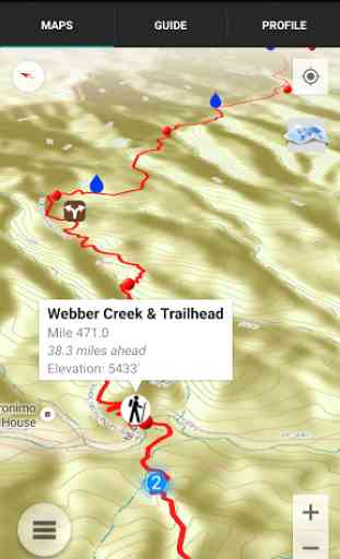
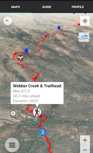
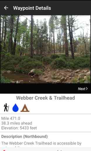
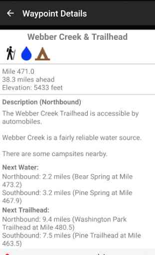
Features:*GPS-enabled map of the Arizona Trail with waypoints*Offline topo maps, satellite imagery, and photos*Full app waypoints: more than 1100 waypoints along or near the trail*Demo app waypoints: 50+ waypoints on Passage 34, near Flagstaff and Snowbowl*GPS-enabled elevation profile with waypoints*GPS-enabled data book listing of all waypoints*Comprehensive water information*Comprehensive town and resupply information*Trailhead information*Detail page for each waypoint*Text or email your location
Types of Waypoints:*Water sources (on-trail and off-trail)*Trailheads and parking areas*Resupply towns/services*Trail junctions*Road crossings*Fences, gates, powerlines, toilets*Other landmarks and points of interest
Category : Travel & Local
Reviews (28)
Somehow, I missed that this is only a demo. Bought the full version for $9.99. Still not sure about it, but at least I have the full trail now. All it would display for me was a small portion of the trail near Flagstaff. Uninstalled.
Very cool app, awesome way to get topo maps offline without a handheld GPS. Once problem, always force closes when creating routes, i can pin an initial spot, but the app closes on the next spot amd resets. Please fix. Galaxy S9
This app has saved me much frustration and kept me from getting lost countless times. I've hiked more than half the trail and most of it is rugged and not always well marked.
I love this app. It's so incredibly useful for figuring out your route as well as potential resupply areas and water sources. if there isn't am app like this for other trails, there should be!
Keeps crashing on Android now when creating a custom route. Pressing for a second waypoint just closes the app. Never used to be a problem. Samsung S20+
Great app! I have just started doing the AZT in sections and it has save me multiple times from going in the wrong correction. Thanks for creating
Absolutely necessary for AZT hikers. When I lose the trail it leads me back. Includes the latest update on trail conditions and water.
App does not work. Opens map but does not give waypoints, elevation or anything else. Just lines.
Loved this app. Was critical in finding water sources and how good the water will be. People's ability to comment on the water was the best. Keep it up.
App does not show coordinates, does not show nearby roads. Gaia shows AZT, other trails, roads, coordinates.
Reliable tool to help stay on trail. Also useful for trip planning.
App crashes when making routes. Tried reloading and changing it but still crashes.
Great app, lots of detail and information on the trail and available resources. Recomended for anyone hiking the Arizona Scenic Trail.
As a section hiker working on completing the AZT, I can say that this makes trip planning and hiking the trail much easier and more enjoyable.
This app is so useful to help you plan out your hikes and resources. I would have a hard time without it.
Lot of useful information while hiking the AZT, better than carrying the book and more up to date.
I wouldn't attempt the AZT without it. You can determine immediately if you've taken a wrong turn.
Absolutely the best thing since sliced bread. Made my azt nobo not just tenable but much more comfortable!
I just did passage 27 solo in one day and it was very well marked considering how rural it is.
This is a MUST app when hiking the AZT. We find it to be invaluable.
Good tool, but user generated vital content about water status is not up-to-date and therefore not reliable
only problem is does not show trail junction numbers...works great even offline.
have a galaxy s9 and the map routes wont load at all. cant use the app whatsoever
I paid full price for this app and I only got the demo section not the entire part.
Kind of glitchy. It's keeps showing my mileage as -8.1 miles off from actual mileage. Example: stateline trailhead should be mile 0 but sites as -8.1.....?????...?.?.?.?. Please Help!!!!!
Excellent app and resource for hiking the Arizona trail.
Great navigation tool, easy to use.
Extremely helpful for planning excursions on the trail as well as very useful for getting updated information on critical data such as water availability. While you should never completely rely on battery driven devices when in the back country, it's a tool I will always have with me on the trail.