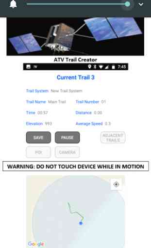
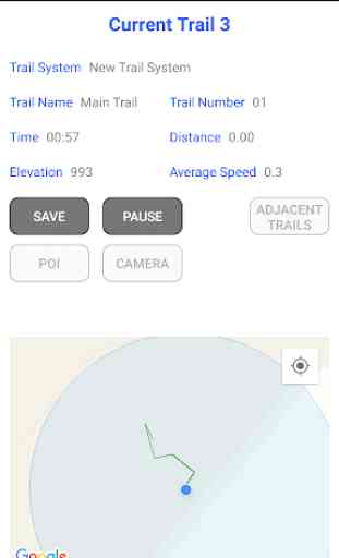
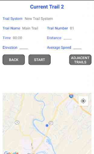
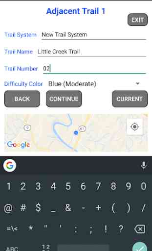
ATV Trail Creator
This App enables the user to gather GPS data for Trails they ride on, including the Trail System, Trail Name, Trail Number and Difficulty Color code including waypoints recorded sequentially as you drive on the Trail. A full set of Trails is called a Trail System. This App also enables you to gather Points of Interest (POI) that you find along the way.
The GPX files you gather can be turned into an Trail System App, by me, making it easy for you, and others, to travel the trails. Your phone becomes a GPS with your trails on it in the resulting Trail System App. I have some Trail Systems on the Play Store already. An example is Sundquist ATV Trails for $9.99. Each App put on the Play Store is named after the Trail System.
I spent a lot of money on programmers over 4 years having this App written, and decided to give it to you, in hopes of cooperating to create Trail Systems you can have free, if you significantly help me by gathering trails. I hope to break even by others puchasing the resulting Trail System.
I am interested in making more Trail Systems available to others on the Play Store at an affordable price and want your help.
Take time to READ the INSTRUCTIONS, and please make Contact with me for Help in the best way to gather trails, and help fixing files you gather that need changes at [email protected].
If you ride an ATV, Side by Side, Jeep, or Off Road Vehicle, you may want to record each trail you ride on, so you, and others, can go back and find your way around. With the App I can create, from your data, you will see where you are on the trails you gathered. I would like to work with you to develop more Trail System Apps. I have the code written and just need to populate it with new Trails and Points of Interest, (and boundaries if you can get them). Examples on the Play Store are Sundquist ATV Trails and Royal Blue ATV Trails. Get in touch, I can put you on the right track to help develop the Trail System with fewer issues and higher efficiently. This App will send me each file you capture, for use as I see fit, so lets work together. You agree to me getting each file you record by downloading this App.
There are three permissions needed, Camera, Location and Storage. Camera is needed to be able to take pictures while in the App. Location is needed to be able to record the Trails you travel on. Storage is needed to save the Trails and Points of Interest you discover, and pictures you take, to your phone. The Trail System name you input, becomes the folder, under the ATV Trail Creator directory on your phone, that the App stores the GPX files in. Some screenshots are of what can be done with the files that you save with this App.
Your phone must have an Actual GPS in it for this App to work, it cannot JUST rely on Cell towers and WiFi for Positioning.
The saved files will open in Microsoft Streets and Trips, Google Earth, GPS TrackMaker, and about everything but Garmin BaseCamp. But, if you download the free G7toWin program, open the file and Save it, then it will open in Garmin BaseCamp. In BaseCamp, create a new List Folder (File/New/List Folder) and drag the file into the new List Folder to open it in BaseCamp. You CAN see the trail you are creating as you create it, but you cannot go back an look at it with this App. GPX Viewer is a Free Android App that you can see the files you created by pointing the app to the ATV Trail Creator directory on your phone.
Don't have an Android phone or Tablet? You do not need a phone number on the Android phone to have this App work, the phone just hast to have WiFi (and or Cell Service) to download the App. The Android phone or Android Tablet must have a physical GPS though. To verify it does have a GPS, go to System, then Location, and look for the initials GPS (global positioning system). If you see GPS there, it should work.
Some of the graphics on the store, that are not screenshots, are of the Trail System app that your trails could be a part of.
Category : Maps & Navigation
Related searches
Reviews (8)
A. G. u.
Nov 27, 2019
Easy to use once you get the hang of it. Use it for mountain biking unsanctioned trails.
A. G. u.
May 16, 2019
Garbage app. Where are my saved trails?? Not much use if i can't see the trails i made...
A. G. u.
Jun 8, 2019
great for recording trails, or just where i went that day.
Chu. V.
Jun 27, 2020
Well I downloaded the app and registered my name email and city I live in and it did nothing 😐 am I doing something wrong
Mel. T.
Jun 29, 2021
Know where it at and what trails to ride on
A. G. u.
Sep 3, 2018
This us going to be great for recording the trails that I hike.
A. G. u.
Aug 22, 2018
Now I can save all the trails I ride on. Thanks.
Just mapping our back bush ATV trails here in Ontario. Still learning how to use it, but great results after a first trial mapping run. I had to find the .gpx file on my samsung phone (wasn't hard to locate with a .gpx search), copied it to my computer, converted it to .kml file with a free converter online, then imported the .kml file into google maps mymaps. Changed the basemap to satellite image, and got a perfect result of the trail in our bush. Exported the .kml file from google maps back to my computer, so now i have a .kml that shows the satellite terrain. Small failure, not sure what the issue is...I tried importing both the .gpx and .kml files into google earth, and it seemed like it imported the files, but it didn't show the trail waypoints or anything. Not sure if there's something in the 'view' or a box i have to tick on google earth in order to show the trails... if anyone has a suggestion that would be great.