Australia Topo Maps
- Perfect for OUTBACK Trips +++
Easy to use Outdoor/Offline GPS navigation app with access to the best topographic maps and satellite images for Australia.
++ For offline use PRO features needed ! ++
Turn your Andoid Phone/Tablet into an outdoor GPS for trips into the backcountry WITHOUT CELL COVERAGE. This app gives you similar mapping options as you might know from Garmin or Magellan GPS handhelds.
Included FREE map layers:
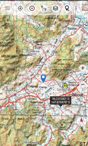
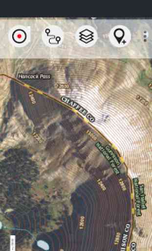
• NATMAP 1:250.000 Topo Maps, latest edition, enriched with hillshading and additional placenames !
• Australia Base Map: Seamless national dataset for whole of Australia. Very detailed !
• Queensland Topo Maps: High resolution topographic maps
• New South Wales Maps: High resolution topographic maps
• Tasmania Maps: High resolution topographic maps
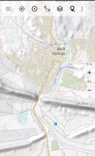
• OpenStreetMaps : These crowdsourced maps are a very useful addition to other map layers. Contains many unique features.
• OpenCycleMaps: These maps are ideal to plan bicycle trips
• Geological Map (for biologists, geologists, miners, ...)
• ESRI Topographic
• ESRI Aerial Images
• ESRI Street Map
• Google Road Map (online access only)
• Google Satellite Images (online access only)
• Google Terrain Map (online access only)
• Bing Road Map (online access only)
• Bing Satellite Images (online access only)
• Earth At Night
• Hillshading overlay
• Transport/Infrastructure overlay
Main features for outdoor-navigation:
• Create and edit Waypoints
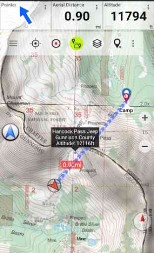
• GoTo-Waypoint-Navigation
• Track Recording (with speed, elevation and accuracy profile)
• Tripmaster with fields for odometer, average speed, bearing, elevation, etc.
• GPX/KML/KMZ Export
• Search (placenames, POIs, streets)
• Customizable datafields in Map View and Tripmaster (e.g. Speed, Distance, Compass, ...)
• Share Waypoints, Tracks or Routes (via eMail, Whatsapp, Dropbox, Facebook, ..)
• Display coordinates in Lat/Lon, UTM or MGRS/USNG (Military Grid/ US National Grid)
• Record & share tracks with statistics & elevation profile
• Rotate map (Track Up & North Up)
• Get Elevation by long click on map
• Track Replay
• and many more ...
Available Pro features: (Pro features available via In App Purchase)
• Offline Use
- no cell coverage needed. No Roaming fees !
• Easy+Fast Bulk-download of map tiles for OFFLINE USAGE (not for Google and Bing maps)
• Create and edit Routes
• Route-Navigation (Point-to-Point Navigation)
• GPX/KML/KMZ Import
• unlimited Waypoints & Tracks
• Add other Map Tile-Server
• No Ads
Offline Use:All viewed map tiles are kept in cache. To cache large areas you need to purchase Pro features.
Use this navigation app for outdoor activities like hiking, biking, camping, climbing, riding, skiing, canoeing, hunting, offroad 4WD tours or search&rescue (SAR).
Add custom waypoints in longitude/latitude, UTM or MGRS/USNG format with WGS84 datum.
Import/Export/Share GPS-Waypoints/Tracks/Routes in GPX or Google Earth KML/KMZ format.
Preload FREE map data for areas without cell service (Pro feature !).
Comments and feature requests to [email protected]
Have a look at our other outdoor navigation apps: https://play.google.com/store/search?q=atlogis
+++ We DO NOT track any user activities or collect any user data ! +++
Category : Maps & Navigation
Reviews (17)
good software, cannot save whole 'zone' maps, and gotta keep an eye on settings encase cached maps vanish... really need to have the ability to save entire maps and not rely on cloud.
It is appalling that developers on mobile platforms feel entitled to receiving a salary from their customers, instead of producing and pricing something decent that sells, like in other walks of life. If a software can only be rented and not bought, such as this one, it gets removed.
Really useless without the pro version. Every where in Victoria that the app would be useful for navigation. Has no signal for free version
Nice to use. However it would constantly tell me that I get 3 Waypoints before upgrading to pro. I couldn't even add one waypoint. In fact, apart from browsing the map, it didn't let me try any other feature. I'm not willing to invest $20 a year in an app I can't try apart from viewing the maps. Something that I can do on my printed maps anyway.
Great app, very useful when hiking. Put in a destination waypoint, it tells you the bearing and distance. You can then use a normal magnetic compass to follow the bearing. Saving maps offline is an excellent feature for when you're out of mobile coverage. Helps a lot when navigating in new areas, and especially useful if suspect you took a wrong turn in the bush when no one else is around. This is the only GPS tool I use.
Fantastic app, have used it for years now. Offline as well. I recently updated to Samsung 1UI OS and now whenever I go to Cache a map the app crashes as it starts to download. I'm guessing it's a compatibility problem. Hope it is fixed soon as the pro version up until this week has been flawless. I'm hoping to hit some 4WD trails later in the week and would like the maps!
Keen to try since the latest update... But has done what I need in terms of uploading a route and following the trail. Has a problem where the map stops moving so you can no longer see the route or where you are. I think it happens every time you stop. A restart of app and reload route needed each time which is annoying. If this is fixed in latest update then I think it's great.
after a hefty price hike this app runs worse, often will not record saying pro version needed (which I am) also will not load sometimes saying there is some sort of error, these usually happen when out in the bush when the app is required to run. Very frustrating. A price increase from $6 to $20 a year is excessive. A great map app with out the hiccups and ran trouble free before the price rise
After using it for 6 months I found it useful to a point. But needs to be able to zoom in to a closer level/scale with better detail. As a basic tool for navigation it's ok but so is Google maps. Even after using the layers. It's hard to find decent topographical maps of QLD. Without paying and arm and a leg for it.
I paid for the pro version and most of the time it works fine. Every now and then, it starts saying "This feature is only available in the pro version". You have to either reboot or force the app to stop and restart, then it works again. I have not been able to create a route offline, may need to more RTFM.
Good app in theory. Planned hike with the app so bought the $80 vicmap premium map. However, this vicmap is broken and does not work. It constantly displays incorrectly. When you zoom in it fails to render correctly and becomes unusable. Far too expensive for something that doesnt work. Will be seeking a refund.
Ok, does the job just, slow loading maps which sometimes hang en route. Retart of app required, very annoying. I suspect part of the problem is the map as a single layer covering too big an area (eg all of AUS is one map layer!) Should be available to load in smaller sections. My mates use other well known apps and never have this problem. Also doesnt co-mingle with other apps well, launching music or my BT headset app shuts it down. Pretty poor implementation overall. Lucky its cheap.
I used to use GPS Kit on my old company supplied iPhone 4. A few years ago I finally cracked it with iTunes and purchased a decent android device. Unfortunately, GPS Kit was not available on the android store. I ended up looking around and have found Australia Topo Maps to be a very useful alternative. I do quite a bit of site work, and find it great for taking geo-tagged notes, saving routes etc. I recently worked on a Project in PNG and was stoked that I could save imagery to the phone in advance to save on data. It was also easy to find old survey positions once imported. One of the real frustrating issues I have found is when exporting the data as a .kml for import to Google Earth when you reset the aerial to North (by pressing R) all the data is no longer visible. Is there a fix to this??
Brilliant app but I can't seem to get it to work with the play store family library. I really want my sons to have it but I can't justify paying another $40 worth of subscription.
[edit][edit] with an almost quadrupling in price for the yearly subscription I'm afraid it doesn't offer enough value for money. In the last set of rapid-fire updates my issue with display lots of waypoints...hundreds/thousands has been resolved at least with the quick look Ive had. well done to dev team!
Brilliantly useful app for exploring beyond the usual Google maps routes. Shows all sorts of forestry roads, and even the street maps of old abandoned townships in the middle of nowhere. Small price for the pro version is essential for being able to download maps for use outside of the phone network. Well worth it!
Works better then I thought it would. The subscription option is useful and is a reasonable price. Just needs more maps, but works everywhere on the basic ones