Avare
* For flying in the USA and some parts of Canada, but provides non current TPC charts for most of the world, and ONC charts for Canada, EU, South Asia, and New Zealand *******
* We do not provide support on reviews page *******
* Support is available 24/7 at https://groups.google.com/forum/#!forum/apps4av-forum */
Avare (pronounced "Av Air") is a free moving-map aviation GPS & EFB app. Note: Internet access is required only for installing the app, an aviation database, and at least 1 chart; then for any updates. We recommend that you TURN OFF AUTOMATIC UPDATE in your Play app, and manually update Avare and then its Downloads.
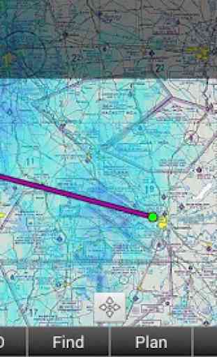
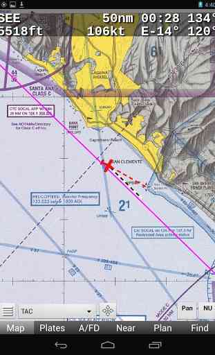
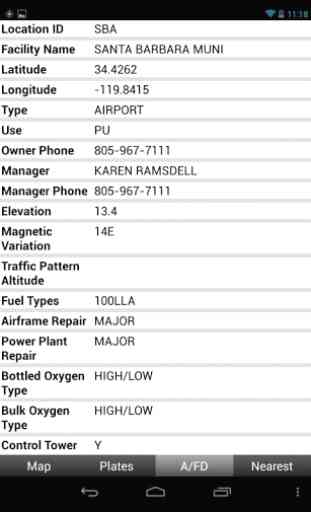
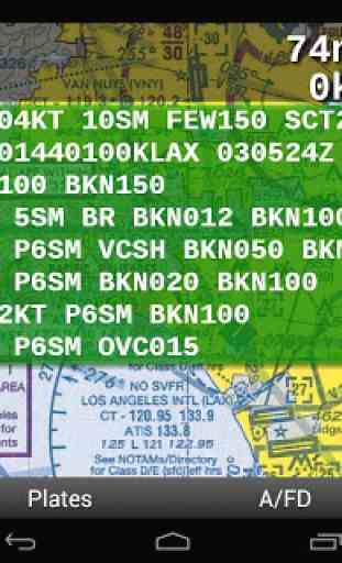
Avare provides offline moving map on all FAA charts (VFR Sectional, IFR lo/hi enroute, Approach Plate, WAC & TAC); plus A/FD info, Airport Diagrams w/GPS Taxi, and Terminal Procedures. Also included: GPS status, Terrain/Elevation Maps, 50 Nearest airports, Obstacles, and more. Some FAA Charts cover Puerto Rico, plus parts of Canada, Mexico and the Caribbean. All of this is Completely Free with no ads (unless you tap Options/Ads to see our sponsors). Canadian topo moving maps and unofficial airport info are also now available and volunteers may add other countries.Note: Like all apps for portable devices, Avare is not FAA certified but may be used as outlined in FAA documents. Also see our NOTICE below, and the FAQ on our website for links to FAA documents.
Avare Advantages:•Made by & for pilots•Easy to learn & use•Quick & responsive•All free FAA materials & more•Runs on most Android devices•No ads or invasive permissions
More Features:•Type in any address or coordinates.•METAR & TAF (Internet fetch).•ADSB NEXRAD, METAR, TAF, PIREP, Winds (free AddOn apps).•Graphic & text TFRs (Internet fetch).•Terrain maps & Canada topo, MSL & AGL display.•External GPS, autopilot and flite sim (free AddOn apps).•Obstacles: Any over 500' AGL within 200' of GPS altitude.•NOTAMS•Frequencies, runways, fuel availability, & other A/FD info.•13000+ Geo. referenced approach plates and taxi diagrams•Landscape or Portrait display Preference, North Up or Track Up (NU/TU).•Draw notes directly on-screen, or Pan freely around charts (Draw/Pan).•Press any two points on chart for approximate distance between them.•Location icon can be centered or track from your placement on screen.•GPS compass direction, Bearing, and Distance to and FROM any point on the map by long-pressing one finger on that point. Great for your ATC and CTAF radio calls.
Avare installation begins with the small app, and then fetching an aviation Database and at least one chart. You can of course choose additional charts and materials for Avare to Download free at any time.
Note: The FAA occasionally changes their charts such that outdated charts may incorrectly display your location in Avare, so be sure to Update any charts you may use in flight! ANY time you plan to Update a chart, first ensure that you have the latest version of Avare and its Database.
After installing Avare, please use the Help feature to begin. New features are being added very quickly in response to user feedback. You can Contact us directly via our apps4av google group Forum to share your questions, feedback, and feature requests.
Launch Note: Press the square Avare Options button at the bottom left of the Map screen to access Help.
NOTICE: This software is provided "as is" and any express or implied warranties, including, but not limited to, implied warranties of merchantability and fitness for a particular purpose are disclaimed. In no event shall the copyright holder or contributors be liable for any direct, indirect, incidental, special, exemplary, or consequential damages (including, but not limited to loss of use or data) however caused and on any theory of liability, whether in contract, strict liability, or tort (including negligence or otherwise) arising in any way out of the use of this software, even if advised of the possibility of such damage.
Category : Maps & Navigation
Reviews (23)
WHAT THE HECK!!!!! Latest upgrade of a great app destroyed by your developers. Lost all 50 plus saved flight plans, weight and balances etc. Going to Foreflight now, they don't screw things up. (previously..) I've been using Avare for years. Great for X-country & local flights. Only concern some map stitching overlays cut off information boxes. I.E. 78° & HGR's VOR & others. Info can still be obtained by looking at the airports pop-up & CSup.
Latest update breaks app. I cannot enable nearby Bluetooth sharing on my device for whatever reason and the latest app update won't allow you to use the app at all without enabling that (and I am unable to)
Requires email to use. They just want to spam you with garbage. No way out except to force close the app. If the intro is that poorly written I'll just stay away. Need something more reliable.
Loved this app until this last upgrade / bluetooth fix. Cannot access the app at all neither on my phone nor tablet. Also have noticed on forum many others having identical problem. Please undo the bluetooth fix. Or tell us how we can remove that fix. Remember though we can not access the app at all 👎
Worked great before last update. App asked for permissions that were granted before the update and after the update. However, now asking for permissions and not working at all.
I use avare as a supplement to another app. It has features my other one does not. The other app has features that avare does not. I use both for a cross country.
Awesome app! Big thanks to the developers! Always works well for my needs. Would be nice to be able to run AHRS display beside the moving map in landscape mode.
Best android electronic flight information app that I have found. Supplements paper charts nicely for my low tech VFR flying.
Works great with navigation but recently doesn't display ads-b in information.
I really like the app. I've been using it for 2 years now. Today I added a Stratux receiver to give me traffic on it. Only problem is that as of the last update, any time I open a different window on my device it loses all of the data and have to reenter the flight plan. Hope they fix it quickly. Edit: Thanks for the update! Solved the restart problem!
It is a simple, easy to use, extremely powerful app that is very stable and rarely if ever crashes. it is easily my favorite aviation app. Totally free including updated maps and plates every cycle. The approach plates are geo-referenced right down to the automatic switch to the airport diagram on rollout. I can't say enough good things about it! Just a truly amazing app!
I have had nothing but great experiences using this app. I recently connected it to Microsoft flight simulator 2020 after following some great instructions from a Reddit user and it works flawlessly. I'll be hooking it up to an adsb transponder next to try it out in the cockpit. Looking forward to new features and updates. Hope to donate more to their cause soon. Impressive that this is a free app. Hopefully it stays that way.
This is an app for pilots. I've been flying with it for about 2 years, and I love it. It's just the basics - moving map, simple flight planning, etc., but it's easy to use and reliable. Simple and free chart and weather updates. I use it for vfr in the ne us, where there is a lot going on, and it's a big help in maintaining sa.
This is a great go to when I don't have my iPad with my Garmin GPS. For a free app., it does all my basic needs. Once I configured to my screen with the options I like, it gives me most of the info. I need. I used this the other day in the back of my friends RV8. There are no instruments back there, and I was able to navigate with approximate airspeed, altitude and stay clear of airspaces with Avare. Since he did not have any ADSB equipment, my iPad was worthless, so this worked like a charm.
I would give app 5* but removing 1* for general usability. I have debated getting a fully paid solution such as Garmin or others but over time as I got used to this, I have never felt the need to go for those fully paid options. Learning to use this app effectively does take time and some things aren't straightforward, but it serves the purpose. It's not easy to connect to ADS-B or open up the AFD of an airport. Other than quirks like that it's great for navigation!
I love the app i would give it 5 stars but I cannot figure out how to turn it off. The navigation is always on and I have gone through everything trying to figure out how to turn that part off. It is always on and very quickly drains my battery and I get all kinds of CPU warnings because of it.and because of that i had to delete it and go with somthing else to get my sectional charts. it's a great app and I love the sectional charts. In my opinion needs to be more user friendly
Good app with geo-referenced plates for free (Foreflight charges extra for that feature!). Good feature set for the price (free), but the UI is clunky. I personally only use it if my iPad isn't handy and I need to do some light flight planning. I also use it for the Geo-referenced plates during approaches, but would never use it as my primary EFB.
Excellent EFB app. This is an open source app so it is truely free and is supported by volunteers. It has all the basic functions I need as an instrument rated private pilot. Map screens are not cluttered and you can select just the maps and coverage you need. Updates of maps and weather are easy one button push and downloads are fast. Works well on both my Samsung phone and tablet. I have been using Avare on my tablet with the stratux adsb receiver. I get in-flight traffic, METAR and NEXRAD.
This app works wonders. I use the Garmin Glo GPS with it when I'm above cell reception altitude. My only complaint is that the weather charts don't all work or load for some reason (AIRMETS, Low and Mid Level Prognostic charts, and all those under the Turb and Icing tabs) even after updating the data from the Downloads section. The weight and balance is difficult to use even after going through the tutorial. With a few minor tweaks and enhancements this could be an even better app.
Very useful moving map. Traffic on screen is a great safety, great speed advice. Weather graphics works excellent. Flying data is good. I like to suggest to add a Bearing (Direct to) Path for easy fly, similar to Route Path (magenta) and, also will be good if we can have NAV 2 DME, RADIAL & Bearing. Switch buttons should be identify w/color when ON. The approach feature seems to be great, if Glide Slop can be add will be even better. So far it is a very good App and it is free. Excell work guys.
Pretty decent all around app that helps great while flying. But the flight planning always seems off with the winds and course headings so I end up making my own with a flight computer. And the nearest page only has airports while most others offer navaids and fixes with filters. Also, when you click on the map it doesn't show the points near there and you need to type them into the find option of the menu even though your looking at it on the map if you want to add a spot to the plan.
Fantastic app with a wide feature set! It's not as polished as GarminPilot, but it's free with no ads! Overall it works very well, though I have a few suggestions and had some bugs while using it: -Notification tray should be optional and default Off -Leave Running option should default Off -Automatic weather update -Weather radar/time-lapse -Weather disappears sometimes even when it's not expired -Airport Diagrams for smaller airports
Good app. Does a lot of things really well. Biggest issue is a general lack of explanations for how things work and little warning when changes are made. The Android environment is a harsh world for developers. Stick with it though. Support eventually comes through with the fixes.