Avia Maps Aeronautical Charts
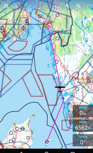
For clarity and commonality to paper charts the map is themed in the style of ICAO Annex 4 (Aeronautical Charts).
This is a trial app with full features. After an evaluation period of 30 days you will have to do an in-app purchase of $9.99 (might vary in your currency). There will be no recurring charges.
Countries with Airspace data:United KingdomUnited States---AustraliaAustriaBahrainBelgiumBosnia and HerzegovinaBrazilCanadaColombiaCroatiaCzech RepublicDenmarkFinlandFranceGermanyGreeceHungaryIrelandIsraelItalyLao People's Democratic RepublicLatviaLithuaniaLuxembourgMacedoniaNamibiaNepalNetherlandsNew ZealandNorwayPolandPortugalRomaniaRussiaSerbiaSlovakiaSloveniaSouth AfricaSpainSwedenSwitzerland
Category : Maps & Navigation
Reviews (27)
there may be a potential to this app, but for now it is useless (except maybe for smaller piston pilots with 2-3 wp flightplans): where are the aiways?! how do you add waypoints in between two existing ones? What kind of mapping that is? Sectional charts - then why they depict buildings? Jepp style charts (icao)? Then why do they include roads and shorelines? This is a draft for future applucation not a product yet, but you already want money? Let us have a look at this app in a year or two...
Straightforward and very useful! I use this app as a backup to my paper charts. It can be a handy tool for preflight, too. Also, I'm glad it's not as all-encompassing as Sky Daemon - I need a moving map with CAS boundaries, not an entire electronic flight bag!
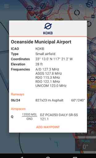
Overall not too bad of an app. Displays good information. GPS position seems accurate. I would like to be able to zoom in more. I would also like the awos frequencies to be included in the airport information.
I like the clarity and most of the detail that is presented and the levels available to select. one big problem it does not include obstacles like radio towers and things like that. Big safety issue!!!
Good app, many options, the map is good and clear but unfortunately, north africa and gulf airspace for example are missing. Hope will be available in the next update 🙏
UPDATE: The good: Fantastic UI/UX, reliability, readability. It has THE BEST designed vector maps (colors, layout, icons, markers) I've seen in an EFB. Customer service is exceptionally responsive. The bad: It only uses Android native GPS data. If you use an external GPS provider that Android recognizes natively, it should work, however it is blind to ADS-B/GDL90 data as well as SimConnect data from programs like Xmapsy rendering it useless for real world and simulated flight. On the ground, this app is A++, 5 stars. In the air or in the sim, it is not practical.
EDIT 3/12/19 Emailed the developer about my issues with the trial period. He immediately looked into it and reset the trial period so that I could use the app. Now that I'm able to use it I have to say WOW!! Very clean interface, easy to use and tons of features! Not to mention excellent customer service as he handled my issue quickly. Well done!
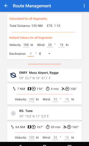
I have just started using it. Looking for a simple and affordable planning tool to check distances and travel times. Willing to sacrifice map detail and eye candy for price as I will use it maybe 10 times a year, so a subscription service is not needed. This app seems to be pretty close to that. 1. Would be nice to enter waypoints using ICAO identifiers. 2. Would be nice to move or drag waypoints in flightplan to different sequence.
Likely the best aviation maps on Android. There are quite a few areas the app can be improved on, but it is definitely step in the right direction. It is currently lacking features that apps such as ForeFlight offers and simpler things like being able to zoom in/out to a desired size instead of predefined zoom positions, loading the areas all over again when paning over the map (by keeping it in cache for example) etc can be improved upon. Excited to see what this app can become.
This app could be great. Their email support seems to be non-existant as I've sent them a few emails with no response. Not filling me with confidence after buying the app. The ability to add your private or local flying school would be a great help. Adding notams and filing of flight plans would also be a great bonus. This could be a 5 star app. EDIT: I appreciate the feedback from developer I think once upgrades happen this will be an excellent app and a top contender to the other apps out there
An extremely high quality app with a bright future. I would love to see save-able and re-nameable custom waypoints (currently custom waypoints are auto-named Waypoint 1, 2, 3, etc.) and more aviation-related items on the map (obstructions, MSAs, etc). I love the integration with Avia Weather. Very well done!
Great user experience. Thank you guys. I have only been using it for 30 mins, so apologies if I have missed something. A few thing I would like to see: 1. Save way points and custom way points. 2. Locking North up so you can't rotate the screen accidently. 3. Runways with their numbers at each end. 4. When clicking on a particular point, the frequency should come up. Great value for money. You can send me an email for other advices. Many thanks once again. South Africa.
Works great, tried it on my Lenovo M8 tab, android 9. (Only tried free version yet). Pros: 1. Fairly easy to use. 2. No monthly/yearly fee. Cons (minors): 1. Could not get map to follow aircraft (I'm pretty sure I missed something/did something wrong, I tried double tapping aircraft symbol). 2. Zooming and rotating map occurs at screen center, not where your fingers are pinching on map. 3. No runway numbers or taxiway letters when at max zoom in. 4. A bigger/larger max zoom out level could be useful (at longer routes I cant see my origin and destination simultaneously). Maybe a userdefinable max in/out zoom? 5. Not sure if being able to edit route while flying is good or bad, nice to adjust route "on the go" but can also be annoying, "oups I accidently added a waypoint". Could have a separate edit mode and normal mode (flying).
Obviously not a full-fledged flight planning application, but if one simply needs to have a moving map with airspace overlay, aerodromes and other basic information for VFR flights then there's pretty much nothing else on the market. Especially for this price.
This product is great for VFR flying, but when you need to do IFR planning, I don't need to see roads and cities and all that extra info. All I really care about are airports, airspace, NAVAIDS, airways, and way points. If you can throw some WX overlays on there, that would be awesome!!
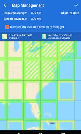
Very promising app, but no chance to download the maps. Tried with WiFi connection, without WiFi connection... the app simply wastes your time by letting you wait. Tried and tried and tried again. I even changed at least 3 different WiFi connections. Nothing. I'm willingly to try again... when and if it will work. Samsung Galaxy S9+
Amazing, I tried a lot of this apps for VFR /VOR flying in MSFS 2020 and this is the best Cheap enough compared to the usable other apps, great option and just works. Request: Even closer zoom option. Even if you don't have the map data I would like love to be at least able to zoom in what is there even more.
I downloaded this app a few days ago. I like the price for after the one month period. No problem there. The problem is even after I downloaded all the zoomed charts of the 3 squares I typically fly in Ontario, I was very dissapointed to find the lack of details for a private pilot like me. I need names of all towns, names of lakes, etc. I need an option at very least to have a VNC and also VTAs of different cities. What pilot is this aimed at?
I am a happy user of Aviation weather and definitely will be buying this one too. Comparing to Air Navigation Pro this app is way better (really 10 times faster rendering) and price wise it is infinitely better. P.S. To those babies who put one star because something does not work - learn how to e-mail to support. Seriously you do nothing good but just hurting development for no real reason. One star is when you hate design or decisions made, not when you can't download maps.
App is superb. As a student pilot I higly recommend this one. Developers are improving app from month to month. Comparing to skydemon - 1) its cheaper 2) easier to use. (OK, it does not have all the features as sd but still worth every cent). I am ocassionally using it and will continue 4 sure. Hope to see some new features soon, keep going devs!!!!!!
Excellent app! Great price too! I have some suggestions though: 1. Ability to name way points (and add permanent ones to have a customized map) 2. Export flight plans in compatible format to Garmin pilot or Sky vector 3. Vertical navigation or a just altitudes to the be flown on a certain leg. For instance between FAPY - > WAYPOINT 1 :7500ft QNH /FL085 4. Automatic magnetic variation (in my area variation changes up to 3° on longer flights)
Easy to use for wind and route calculations, but can't be used for navigation at least in Finland. The maps are not correct even though they are updated often and also radio frequencies seem to be off
Awesome app. Please add waipoint rename and minimum safe altitude for each selected selected waypoint, area or leg please ;). Also in the basic route planning you have speed and direction to each leg. Try to add time enroute for leg too if all wind data is inserted :) thanks
I'm a android user and considered switching to IOS just for foreflight on my phone. Glad I didn't because this ap gives me everything I'm looking for! Some more updates and this could just be the next best thing to foreflight. Possibly partner with windy to get their radar. Love both Avia weather and Avia maps
Bait and switch. App doesn't mention up front that it's a free trial but ultimately a paid app
No ability to have map rotate to actual bearing is a dealbreaker for ultralight vfr in my mind. Zoom level could be a bit more for my purpose as well. Thanks for informing me. Updated to 4 star and will continue to evaluate with this feature.
I like this app very much! I am missing just one thing, and that is elevation data on any point I click (in the info box). Other than that, for the price this is a pretty sweet deal and great backup. I like the color theme very much as its very close to official aero maps in our country!