AvNav EFB
- includes Fuel prices and Geo-referenced approach plates and airport diagrams. For Flying in the United States only. AvNav EFB is an advanced Electronic flight bag (EFB) for pilots who enjoy local and cross country flying through variety of terrain and weather (sometimes in IFR condition). If you are a VFR flyer you will find our simple "Direct To"" navigation combined with easy to use tab-driven interface and always-on rubber-banding simple enough to get you started. If you fly long distance facing terrain or weather, we have many advanced features such as Victor Airways support and support for Winds aloft in flight planning. Program can show terrain above you in red and you can insert DP/STARs and Instrument Approaches into your flight plan with easy menus.AvNav Feature Highlights•Stitched seamless VFR Sectional, TAC and IFR charts
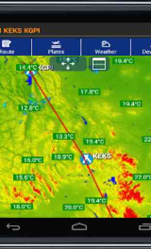
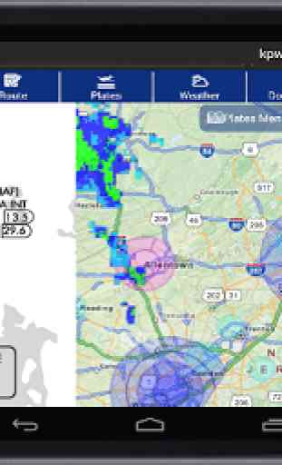
- whether its North up or Track up mode, our charts are always high quality and fast rendering •Static and animated/looping Nexrad, Satellite imagery and AIRMET/SIGMET/PIREPs are shown overlayed on the map page.•Uncluttered Weather Markersshow METAR parameters such as Sky condition, Ceiling, temperature on the map page itself providing unprecedented situational awareness. Also shown on the map page are TFRs and various classes of air-spaces (Class B,C,D)•Terrain: see terrain over your altitude in red and know that you will be able to clear terrain ahead of you.•Geo-referenced Approach plates and Airport Diagrams see your plane on Airport diagrams and Approach plates
- either in full-page or split-screen mode. These charts can also be overlayed on map page
- thus showing terrain, weather etc over them.•DUAT Filing and Briefing
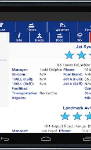
- You can file an FAA Flight Plan and get weather briefing from the App itself. Most information is automatically copied from active flight plan thus reducing any need for typing.•FBO Information and Fuel prices (updated daily) are included in the App. Fuel prices can be shown overlayed on the map page itself. You can search for lower priced fuel and FBOs in the Air.•Fast downloads via Amazon AWS CloudFront
- while you do not need any download other than the App to get started, for cockpit use offline charts are required and available via AWS CloudFront. Our downloads are fast and you can download multiple charts at the same time. You can also continue to use the app while download is in progress.•In the Air, AvNav shows your GPS position on the charts and gets updated information from ADS-B receiver of your choice to display traffic and weather on the map page.•Practice approaches like Pros
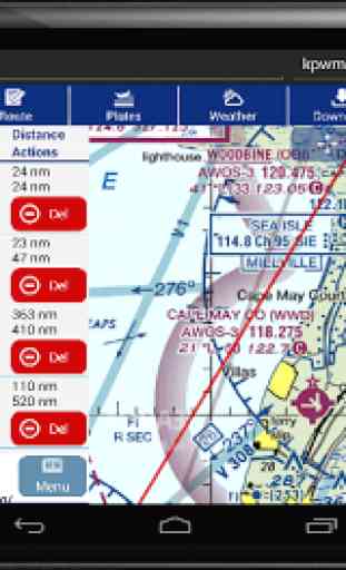
- using easy menus all the waypoints of approaches and their altitude information can be inserted into the flight plan. You can also load DPs, STARs and Victor Airways thus reducing need for typing.
AvNav EFB is an advanced Electronic flight bag (EFB) for pilots who enjoy local and cross country flying through variety of terrain and weather (sometimes in IFR condition). If you are a VFR flyer you will find our simple "Direct To"" navigation combined with easy to use tab-driven interface and always-on rubber-banding simple enough to get you started.
If you fly long distance facing terrain or weather, we have many advanced features such as Victor Airways support and support for Winds aloft in flight planning. Program can show terrain above you in red and you can insert DP/STARs and Instrument Approaches into your flight plan with easy menus.
•Stitched seamless VFR Sectional, TAC and IFR charts
- whether its North up or Track up mode, our charts are always high quality and fast rendering
•Static and animated/looping Nexrad, Satellite imagery and AIRMET/SIGMET/PIREPs are shown overlayed on the map page.•Uncluttered Weather Markersshow METAR parameters such as Sky condition, Ceiling, temperature on the map page itself providing unprecedented situational awareness. Also shown on the map page are TFRs and various classes of air-spaces (Class B,C,D)
•Terrain: see terrain over your altitude in red and know that you will be able to clear terrain ahead of you.
•Geo-referenced Approach plates and Airport Diagrams see your plane on Airport diagrams and Approach plates
- either in full-page or split-screen mode. These charts can also be overlayed on map page
- thus showing terrain, weather etc over them.
•DUAT Filing and Briefing
- You can file an FAA Flight Plan and get weather briefing from the App itself. Most information is automatically copied from active flight plan thus reducing any need for typing.
•FBO Information and Fuel prices (updated daily) are included in the App. Fuel prices can be shown overlayed on the map page itself. You can search for lower priced fuel and FBOs in the Air.
•Fast downloads via Amazon AWS CloudFront
- while you do not need any download other than the App to get started, for cockpit use offline charts are required and available via AWS CloudFront. Our downloads
Category : Maps & Navigation
Reviews (26)
IFR Low charts are missing around GA/SC. They are downloaded but don't display, just blank space. Can download TACs, but no way to display them. Still haven't fixed class B altitudes on vector charts (check out KMEM). New version in works seems to fix and offers nice updates, but is still buggy (as of 5.1.93).
I've not had many issues with the app. I would like to see things like the Grand Canyon VFR sectional, as I go through there from time to time. I always have to ask LA center for the waypoints.
An affordable and formidable alternative to ForeFlight. Easy to use, easy on the wallet. Could use a few tweaks here and there which I have already brought up. I'm not a 5 star kind of guy, and this wouldn't let me give 4.5, otherwise I would have. Good job team.
Looks good and seems to be pretty versatile, BUT only covers the US area and gives no options to add maps from different sources.
Just force-quits repeatedly - won't run at all
Only US charts? Useless for the rest of the world...
I have new version installed, keeps saying new version is here need to install... Such in a loop? I do like the app when it works
A Great Flight Navigation app to use for all your flight travels.
Installed the trial and decided I will stick with IFLY GPS. It has served very well and the producers are very responsive. It just gets better with every release. After playing with this app I am continually surprised at all its features. It would be nice to have a manual. However, I have yet to be able to see the same targets that my IFLY GPS app shows.
Only with US Charts. Useless for the Rest oft the world. Also user interface not intuitive but cluttered with features you'll need to guess what they are for.
Speeds for downloading charts were too slow however it would have been tolerable but it kept crashing. Samsung Note 8 and I couldn't turn on the app without it immediately crashing. Uninstalled
Always liked it. Great and simple interface. By far, the best Android efb.
I like it quite well. I downgraded one star because it will occasionally require you to "log in". Since I plan flights with other methods, this inconvenient log-in can occur in the middle of a busy flight. Lame. Note: the authors replied to me that "We have eliminated login requirement and forced App updates for paying customers." This is good news. With that, I would give them five stars.
Crashes and never starts
Love the new 4.0 update. The vector maps are a huge improvement over the raster charts. Keep up the good work Sanjay and team!
It's really great
Great total EFB app! Very comparable to Foreflight, but not near as expensive when you compare with purchase of iPad plus the app! I don't have an external GPS unit; but, I'm impressed with its accuracy. Few bugs still I wish could be fixed by the developers of AvNav... one being occasional "crashes", but, very thankful that it "restarts" very quickly in flight and you DON'T lose your position on GEO reference on the chart. Hope this helps. I do highly recommend this app for any Android user out there who wants a good quality EFB flight app for their android device! Update to my review (3/18/2018): since having this app and received updates, I can say that the app has improved greatly, and as stated, no more crashes during flight use. I still highly recommend this app over any other Android app that I have previously used. Keep up the good work AvNav and I keep looking forward to new and more improvements.
Newest version from January 2018 has some new improvements that make the app feel very snappy. There are a few new features as well and the design has changed slightly. I hope over time more advanced features are added.
Instead latest version on my phone and it does not run.
Program keeps shutting down. Reinstalled multiple times but still doesn't work. Not worth all the headaches.
Can't use nexrad in mi phone
Works as described and equals or exceeds Garmin Pilot. Cheaper than GP.
Great app for the price
Disappointed. This app could be great. Mine started closing itself at random with no user input. I've emailed and sent the error reports, with no response. This App is almost worthless as an efb right now. Maybe next update will be better.
Updated 3/22/17 - Pros: This app has a very user-friendly and intuitive interface. The on-the-fly rubber banding is great, the flight planning features are as good as or better than other Android apps and the ability to load approaches/SIDs/STARs sets this one above the rest. I have noticed that the frequency of crashes has improved greatly in the past few months; only once in a while, and the rapid start-up helps. Price is reasonable and includes geo-referenced plates! Cons: ads-b targets are too big and block information if in a crowded area; also, i haven't found a way to show the relative altitude to ads-b traffic, that would be good to know information. Email support response is slow to non-existent. For non-supported requests/questions, a simple "not supported at this time" would be good.
The software looks great and runs well even on older hardware. However, the loading times for map segments from SD card is extremely slow when scrolling around. Sometimes it takes 10 seconds for segment to load. The bigger issue is that the software does not seem to understand USB GPS receivers even though they do show up in a USB-Serial terminal on the same device. I wish I would not have to explicitly purchase a bluetooth GPS receiver just to be able to use my Amazon Kindl Fire 8.