
BackCountry Navigator XE: Outdoor GPS App (New)
You can also subscribe to the XE List to get notified of status, updates, and deals.
While many of the goals of the new app are the same, we are hoping to achieve a number of goals with the new platform:
Cross-Platform
The original BackCountry Navigator PRO is only available on Android. We will be bringing BackCountry Navigator XE to Android, iOS and the web.
The corresponding app for iOS will be launched through TestFlight
Planning In The Cloud
The website bcnavxe.com is the web interface for BackCountry Navigator XE. With it you can plot points, routes, and boundaries for trips, and download them on demand in the mobile app. You can push trips created in the mobile app to the cloud as well for reviewing or sharing.
Easy Grid Based Download of Maps
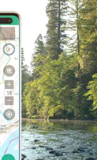
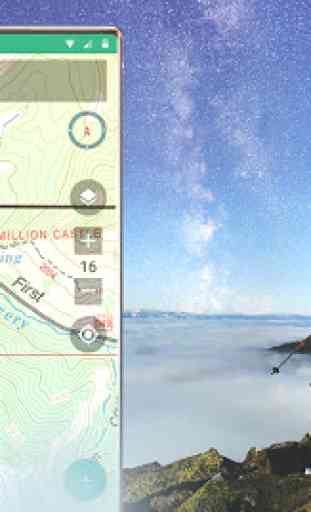
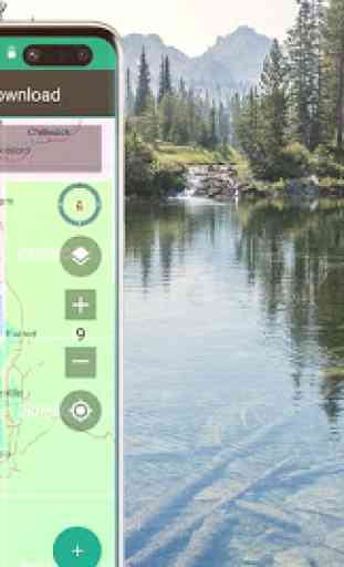
You can try out a simpler approach for downloading and organizing offline maps, choosing large squares at a time. Visualize what you have and what you need.
Vector Topo Maps for the World
Vector topo maps for the world hold the promise of crisp multilevel detail, with the ability to download large chunks of the earth's surface in a quick, compact operation. The BackCountry topo map for the world can be viewed in this app and on bcnavxe.com, with an easy process to install them in large blocks.
SALE: 5 and 10 year plans now available for a limited time at bcnavxe.com.
Use coupon SUB2020 to save even more before the end of the month.
If you are looking for an already proven and established product, also consider BackCountry Navigator PRO. Support and development of that app continues on a parallel track.
https://play.google.com/store/apps/details?id=com.crittermap.backcountrynavigator.license
Category : Maps & Navigation
Reviews (13)
This app is great for navigation outdoors. Wide variety of excellent map sources, including a vector topo map that's very efficient in terms of file size. Powerful tools for drawing and measuring on maps (for when you want to know how much farther it is). Good integration with a website for trip planning if that's your preference. I've tried several outdoor navigation apps and this is the best I've used.
I've tried various GPS mapping apps and Backcountry Navigator is the best. I'm a walker/hiker in the UK and have using the old "Backcountry Navigator Pro" version for years, and it's been super. The huge plus for us in the UK is that it includes (free) OS 25000k scale mapping, which is the best map source in the UK, but also provides the option of using the free 4U topographic maps, aerial view maps and lots more, and switching between maps is really easy and useful when I'm out awlking. But vector graphics, which is one of the things this new XE version is bringing, must be the way forward. So I've already subscribed to this XE version and tried it, and although it's still being developed it's already a very good app. And I'm confident these people know what they're doing and it will soon be my preferred version.
This app helped us find our way many times. It takes a bit to learn (because it does so much.) Offline mode is a must and it comes through. There are TOPO maps and they really help navigate. Many maps to choose from. The developer works his tail off to make it more useful. There are trails we would never have found without it.Kudos to the developers.
I am struggling to break out of being a 'beginning user' of this app. I started with MotionX, then went to an Android phone and BackCountry Navigator, so I have some experience.I use it mostly for day hikes in new areas near or in National Forests in the Colo mtns. I was one of the Beta testers of this XE and I don't think that worked out for me or Backcountry Navigator. Every new process I try to learn is way harder than I expect it will be. I have learned a few things about base maps with all the stumbling around. It seems that the last great series of maps was the USGS 24000 topo quads during the photo revision era before maps were digital. Now there are a plethora of choices and not one is as thorough, accurate and readable as those pre-digital maps. Yes they are still available, but now they are out of date. It seems most practical to forget their outstanding quality and move along to the new world of custom maps where no one map has all the info you would want. The 2016-2019 versions of the USGS 24000 topo quads disappoint consistently. Missing roads, utility lines, trails all kinds of things shown on the pre-digital maps. Some day these digital maps will be definitively superior, but I haven't seen it yet. Still trying to become proficient with XE. The emails from Nathan have really helped keep me connected to this product. I wish other app creators would copy this excellent follow up service.
The process for adding waypoints is poor, as it's very hard to place them correctly unless you are stood on the spot you wish to pin. You also can't add them without creating a "trip", which I can do easily on other apps. I was considering switching to this from Offline Maps, but it's poor by comparison. *Response to dev - you can tap anywhere but it's hard to place points accurately in your app. Also I know a trip can be created with the first waypoint, but I shouldn't need to.
I'm here to edit my previous review. The folks here are quite responsive and feel like they are pretty straight forward. The forest service maps aren't as good as they used to be but sounds like they're working on it as a third party withdrew. Found another app for my Forest service maps. I think given this a shot for the cloud connectivity on my info when I change phones is the move.
I have used the app since it first came out in beta. I used Backcountry Nav Pro before that. I have tried other navigation/gps maps and this is by far the most useful app i have found. I have a Samsung 9+ and do not have any issues with crashes or sign on problems. The app works great for hiking, hunting, fishing,etc.There are many different map styles/info to choose from. I highly recommend it for anyone that loves the outdoors and exploring anywhere.
I've used this app (and earlier versions) for many years. Not the easiest user interface to learn but the app capabilities and access to map collections are awesome. I've downloaded and used topo maps while hiking in Spain, nautical charts for sailing in the San Juan Islands, and various maps for exploring closer to home. Developer is very responsive.
It's not terrible, I wish it would show the hwy, maybe even just the number in the highlighted line, not all of our places we go too, do we know all that well, would sure help in navigetion. I see the smaller roads, which is awesome! Thank you for that. I just don't want to have to use several maps
I spend a lot of time in the backcountry, hiking, hunting, fishing and generally roaming around. For each activity, I have some specialty apps but BC Nav XE app is the one that seamlessly bridges all activities and the one that I rely on the most for actual navigation rather than waypoints, ground feature references or sat imagery. I've tried a few others like Gaia and All Trails and while they are useful in their own way, the true test of an apps usefulness is the frequency with which the user goes back to it instead of other alternatives. This app was easy to become habitual towards although much of that was the presence of the BC Backroads Maps product. While BCMB have their own app products, this app is superior in every way and if I was part of the Mussio management, I'd be looking to buy out this app and hire the developer. Honestly, if you are on the fence, give this app a try. It is a great product and the developer works harder than most to continuously improve it.
Love this app! Rarely use my Garman handheld GPS any more as this app makes it obsolete. Love all the map options and ability to plan and up/down load trips on my computer and then share to my phone. Even bought a tablet just for this app to use while driving back roads in my 4x4. If you want a turn by turn driving app, this is not for you, but if you hike, bike, hunt, offroad, heck any type of outdoor activity, need topo lines, want to know public land boundaries, then this app is for you!
I've had BackCountry Navigator for several years, going back to the original version. I currently have an HTC U11 (Android 9) and I used the app on earlier HTC phones. The app works fine. I did not observe the startup problem some noted because I had not used the app recently. But with the latest update to ver. 1.8.5 (2-17), the app works fine for me.
I had purchased the developer's previous Topo app, but instead of enhancing and improving that one, this new app was created -- which can no longer be purchased but only rented for expensive recurring subscription fees. We know the usual whining and pretexts with which companies on mobile platforms try to justify their greed, as if companies in the real world would not maintain/service/develop their products, too. Consequently, this milkingware is now being uninstalled.