BaseMap
-Harvest Statistics-Draw Odds-Land Ownership Maps-Mobile GPS (Offline caching coming soon)-Advanced Hunt Planning-Saved/Synced Hunts-Sun, Moon, and Weather Data
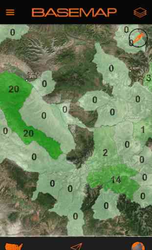
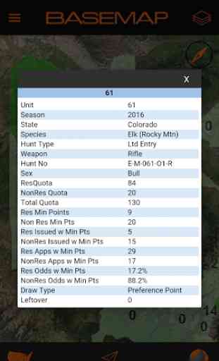
-Increase your chances of success by knowing what units are producing the best harvest results. -Increase your chances of drawing a better license or tag by knowing the odds and points for each hunting unit.-Know where the animals are in each unit with detailed species habitat/distribution overlays.-Know your current location with GPS navigation and land ownership maps
The BaseMap mobile app is a companion app to an online BaseMap subscription sold separately. To create an account please visit the BaseMap website.
Mobile Features:
MY HUNTS
-Access your saved hunts from BaseMap’s online hunt planning application-Saved map location-Hunt Details-Saved Waypoints-Saved Routes-Rules/Regulations-Direct links to state F&G agencies for purchasing tags and harvest reporting
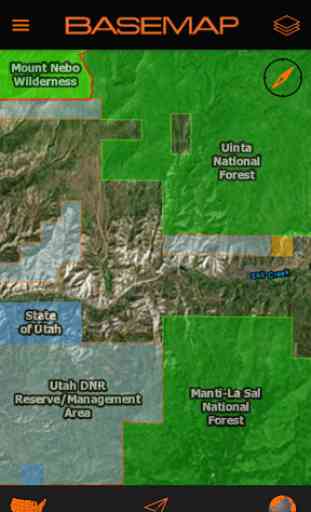
MAP OVERLAYS
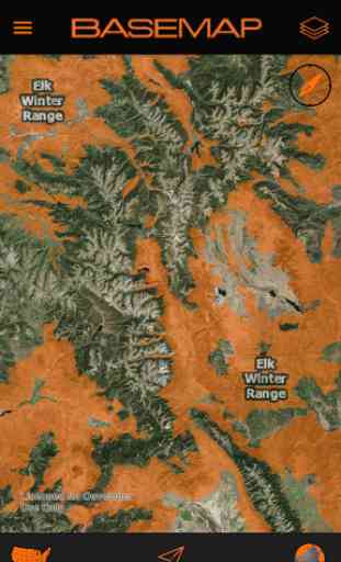
Species Maps-Unit/Hunt Boundaries-Draw Odds with clickable data (Elk, Deer, Antelope)-Harvest Data with clickable data (Elk, Deer, Antelope)-Habitat/Distribution Areas-Specialty Units
Land Status Maps-Color coded Government Lands-Nationwide Private Parcel Names & Boundaries (with Pro Sportsman Subscription)*-WMA's-Restricted Areas-Designated Wilderness Areas-Designated Roadless Areas-Public Access Areas-Fish & Game Access Areas*Where county coverage is available
Access Maps-U.S Trails by NeoTreks (Nationwide Trail Layer)-U.S. Roads (Nationwide Road Layer)
Other Maps-Historic Fire Perimeters (2010 and later)-USFS Timber Cuts (2000 & later)-Points of Interest-License Providers-Field Office LocationsMap sets may vary slightly from state to state
With a BaseMap subscription you also have access to these powerful online hunt planning features:
RESEARCH TOOLS
-Hunt Finder/Filter -Map Engine-Interactive draw odds-Interactive harvest data-Detailed Season Dates-Application Fees and Dates-Moon phase Data-Powerful map engine for unlimited map viewing and desktop scouting-Rules/Regulations-Links to purchase/apply for tags & licenses
DESKTOP SCOUTING
-Map Engine-Add Waypoints-Add Routes-Measure Distances-Save Hunts
HUNT MANAGEMENTThe most helpful tool ever designed to manage all of your hunts. BaseMap organizes everything for you...automatically.
-Save all your waypoints, routes, and photos-Generate a Hi-Res image of your hunt area for map printing-Add detailed notes about your hunt-Photo gallery for each hunt-Hunt summary for each hunt with fees, dates, and unit info-Hunts automatically sync to BaseMap mobile for in-field viewing/navigation-Rename/delete hunts
*This is our initial mobile release and application requires Wi-Fi or cellular coverage for map viewing and other features to function properly. Our offline navigation features will be available soon*
BaseMap's goal is to build the very best hunt planning and navigation tools available for hunters. We have many exciting features we will be adding as well as expanding our coverage areas for data and maps.
If you experience any problems or would like to send us feedback, please reach our team at [email protected]
Category : Sports
Reviews (25)
Horrible. Just wasted 40 mins of my day to make one waypoint. Registered but never could put in user\password to work. Used FB once but next time it would not go. Kept interupting back to upgrade and while i was trying to learn app. So far
I have used the "pro" version for 4 months so far and have had not operational issue with the app. There are a few County owned parcels in my area with no ownership data, but mostly is very accurate. Aerial imagery appears to be from Google Earth, so it's not always the most up to date but is pretty good quality. It is definitely worth the price they charge and I do recommend it. The Gear Drop is also interesting and gives users a very nice carrot to chase.
So far I think this app is really cool, I spend a great deal of time in the bush so being able to map out different land areas has definitely kept me out of trouble, the off line maps is also a very useful feature. Great app and strongly recommend to hunters a d anyone who loves the outdoors
It's been a solid app, won't be using it for this year's hunts for the simple fact all of my hunting partners use the other app and we can't share waypoint or anything with each other.
This does nothing. It's basically the same as Google maps. Annoying and frustrating. I'm better off using my geocaching app.
This app needs much work to the GPS calibration. Also I payed for the pro version and after the last update, it will not let me download offline maps. Other than that there are countless layers and features.
I use it for hunting in Southern Ontario, Canada. Walking through the bush it holds a GPS signal great. Two reasons the app got a 4, it's a little on the expensive side and it doesn't look like the Pro and the maps cover Canada.
Great quality satellite maps, trails are very accurate, and the interface is very easy to use. If you love hiking trails and getting off the grid this is the app you need!
I am not an outdoor type of person & I RARELY go into the unknown of the wilderness. I downloaded this APP as a "what if". As I write this, I'm in the Arizona Desert 4x4ing in a group, & our Physical Map is almost useless. This APP is working flawlessly keeping us on point & from getting lost & leading us to the landmarks we are seeking. If you frequent the outdoors, I would suggest this app & going PRO would no doubt help you immensely & be beneficial. 5 stars!.
Was better when the maps showed the property lines. Didn't care owner's name, but was nice to be able to see property lines, especially out of the cities. Would rate it much higher if property lines shown.
This is a question but a review. I can't seem to find anyone to ask. And I'm sorry if this is a stupid question ( I was born blonde, so bare with me) Why does the app need access to my contacts, pictures or storage? Please help
Developer has twice removed my review. The review is not derogatory but based on factual use of the app. I purchased the pro version and immediately noticed there were several property lines that were incorrect. The landowner name was also incorrect. If you need this for property lines I wouldn't recommend.
The app keeps force closing. Won't open
Very cool app interface but needs optimization for android 12 some new phones like Samsung S22plus and ultra have multi band gnss with the new architecture of soc for example it can pull gps data from L1 and L5 giving better accuracy not a problem right now as Very few apps have been optimized for this but would love to see future support
Been using Basemap for about 3 years. It just keeps getting better and better. Outstanding app for hunting, fishing, and back country hiking.
I currently have a subscription to all of the well known map service apps. I have to say this app seems to be the most well rounded as far as features, detail, clarity, and ease of use. Also the gear drop feature is very entertaining! However there are a few features that are missing or in my opinion seem lacking. The biggest issue being you cant switch from topo to satellite via a hot button on the map screen. Seems silly but it's very annoying! Also the 3D feature leaves a lot to be desired.
The free version is pretty good but the pro version doesn't really offer much of an upgrade. For example, in the pro version you can download "high resolution" offline maps. However, only the "Mapbox" layer is available for download. The main problem I have with this is that the area I am looking at (Telluride) shows snow over the entire mountain range and you can't physically see the trail (it's not like this with the Google Satellite Imagery, but you can't download Google's) . I understand this does not apply to many other areas but it is quite useless for my intended area. Another strange note on this is that when you zoom in to near 100% on the snow covered area, the snow disappears and you are given a view of the land beneath the snow. The problem here is that its so zoomed in you cant reference any of the surrounding area. Lets talk about the 3D Earth view. It is only available for OIS, but I have an Ipad from work so it kind of works for me. First, the imagery is beautiful and the trail overlay is very helpful. However, you can't download this basemap, secondly, you can't adjust the pitch very much like you can in Google Earth. It is still a very nice feature though. One benefit of the Pro upgrade is the USFS MVUM Roads layer and the ability to download it as an additional layer. I really like the ability to turn on/off layers so the screen is not too crowded. This was the main reason I did not go with OnX Offoad, because you can't turn off their layers and it is too hard to orient yourself because of all the clutter. Another nice feature (free or pro) is the trail descriptions you get when you click on a trail. Some trails even include a link to the Forrest Service website for further info. Upgrades I would like to see is Google Satellite Imagery as an offline download option, route planning as can be used in Gaia, 3D Earth for Android, a weather layer or at least a link for the area, the ability to click on a trail and have the option to download an offline map to automatically cover the area for the length of the trail. Another option to include would be to filter trails by activity such as what OnX Offroad does with their "choose your ride" feature or how the COTREX app does it. I hope this helps someone and I hope the BaseMap takes note and can use this to edge out the competition and give us a phenomenal product. Thanks for reading.
I tried out several other apps before settling on this one. The UI isn't cluttered, and the different map layers are great, I actually found a hiking trail near my home that I wasn't aware of while fiddling with the different layers. I look forward to trying this app in the field once the weather turns nicer, and as of now, I am planning on subscribing if it works well.
Great app!!!!! Absolutely one of the best GPS apps for hunting that I've tried. Loads of clear content that is easy to navigate through. The free version has plenty of data and info to make it easy to travel through woodland and get you back to camp. I can't wait to try it out on a big hunt. If the paid version is even better than the free version then this will be my go to app for any kind of activity, not only in the woods but for travel as well. Great job to the developers.
Excellent app. Easy to use, runs fast and is responsive whether online or offline, and has tons of layers for just about anything you could need for hiking, hunting, fishing, mountain biking, offroading, or anything else that takes you away from paved roads or cell reception. The premium subscription is well worth it and is priced very reasonably for what it provides.
Awesome app! Have used it on several hunts where I had spotty phone service or no service at all. Used the cached map feature and it worked perfectly. Had Google imagery, USGS topo maps, public land, and private land layers all offline. No hangups or glitches. Couldn't be happier with it. I'm in the app all the time scouting for new areas. So many different data layers..its awesome! Have hunting buddies that use a competing app and after seeing me use Basemap, they are switching. Definitely get way more for your money compared to the competition. Thank you Basemap for putting out a great product.
every time I try to zoom in the app throws up a sample hunt data app asking me to upgrade and zooms me way out of what I am looking at. Why? this makes the map almost unusable when zooming in to look at details. Please fix this. Otherwise I like the features and hope you run a patch to fix this. thank you...it has something to do with your hunt boundaries for NM layer.
Can't disable notifications, and latest update has added way too many notifications. Overall, I'm sure it's a good app for it's purpose, but it's one i rarely have a need to use, but like to have available. Unfortunately, the latest update has created several daily notifications. I'm not trying to win any free hear, and i don't care about this junk y'all keep popping up in my phone. I really despise the fact that i can't disable these notifications, so I'm uninstalling. Oh well.
if you are an onx user but always feel like it's lacking depth and control then look no further, this is the app for you at a fraction of the cost. first thing i noticed was the ability to actually zoom all the way in like G Earth. basemap customer support and engagement is awesome! I've emailed ideas and little tweaks that i feel can really make this app shine and they've been happy to receive it. i really believe they want to provide the most useful mapping solution to outdoorsmen and women.
Just started to use it. It is way more intuitive then the competitive "Pro" product. I do NOT feel like I am constantly fighting this product or waiting for it to do something. Just finished 3 days in the Bush with Basemap. It was incredible. It exceeded my every expectation. The more I use this app the more I like it. It is just to bad I am not in the USA. In the US is where this app really shines.