Blue Ridge Parkway Travel Planner
Brought to you by the Blue Ridge Parkway Association in cooperation with the Blue Ridge Parkway, National Park Service. BRPA has been serving visitors since 1949 as an official partner organization of the Blue Ridge Parkway dedicated to providing tourism and hospitality information to the Parkway traveler.
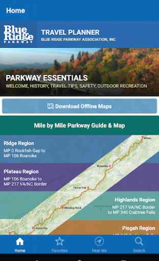
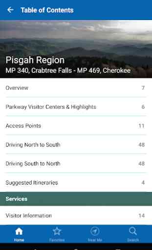
Access detailed information for the Parkway’s four major regions Ridge, Plateau, Highlands and Pisgah as well as information for connecting regions including the Great Smoky Mountains National Park region (located near the Parkway’s southern end) and the Shenandoah National Park region (near the Parkway’s northern end).
Explore by region, activity, or by proximity to your location. Download the app to your phone to access content with or without a cell signal during your trip to visit the Blue Ridge Parkway area, or use it to plan your vacation before you leave home.
Features include:
- Online mapping and navigation
- Parkway visitor centers
- On and off-Parkway campgrounds & lodging
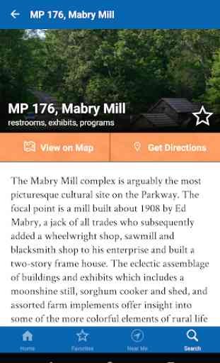
- Interpretive stops on the Parkway
- Gas availability and travel information
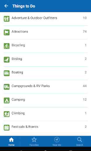
- More than 50 popular hiking trails
- Suggested itineraries
- Major access points for the Parkway
- Adjacent Parkway communities and services
- Wildlife information
- Special events
- Save places to your Favorites list
- Use your GPS signal to explore nearby points of interest
This free mobile application is published by the Blue Ridge Parkway Association to help you more fully enjoy your Parkway area vacation. Our members include attractions, outdoor recreation sites, accommodations, restaurants, shops, and a variety of other services essential to the traveler. This mobile application does not imply endorsement by the National Park Service of the businesses or commercial services listed. When you visit their place of business, please let them know you found them in the Blue Ridge Parkway Travel Planner mobile application. This will help us ensure the future availability of this application for visitors to the Parkway area.
Category : Travel & Local
Reviews (30)
Despite the claim that this app does not need mobile data to function, every time I started it in the middle of nowhere, on the Parkway, it asked for data to update. I downloaded the maps, of course, for offline use, but the app would not skip the screen asking for data. Completely useless in the field.
I'm excited to have this as an option. It's great to have all the maps in one place and be able to download it for a cheap price. I know it also goes to support the Blue Ridge Parkway. Good usability of the app and appreciate that all the trail maps are also in one place downloaded on my phone.
Planing a trip to drive the length of the blue ridge parkway. This app has been so helpful to find things. Not all hiking options show up on the map, so look around.
First reaction is wish I knew that the offline maps, promoted on the website since cell signal can be lacking, cost $1.99 to download. I'm a AAA member so got printed maps free from them. Fair enough, gotta pay for this app etc, but a bit of bait & switch. Bigger issue: Lists don't sort by mileage post correctly. You get MP10, MP100, MP 300, then MP 56, 88 etc. 1-9 sorting by 1st digit of the MP. Maybe it would work better on the road with GPS on, but for pretrip planning it wasn't ideal.
I havent used the app that much yet. So far seems there is a ton of information available . The map is great how much it can be magnified for detail. The listing of gas stations is nice addition to apps content.
App was good for tracking progress through the parkway. It didn't help with road closures or detours. The dining section wasn't helpful either. It was helpful for planning gas stops.
Trying to plan my trip I downloaded this app. The map links to Google maps which wants you to get from point a to point b as quick as possible in the shortest distance. The whole idea is to stay on the parkway!
No info on park lodging - all of the lodging and camping info is for private businesses nearby. There is no info on the campgrounds and lodges that are on the parkway. Also, the map doesn't show mile markers, even though points of interest are identified by mile marker.
Great map free,has suggestions,rates level of trail,lists distance and even how busy it is. The downloaded map that needs no internet service is perfect for mountain hiking
Was better when functions included all highlights bear where you were driving. Now seems they're missing, only show the one place you're going towards
search functionality and trip planner is not user friendly. no info on pet friendly lodging.
Not impressed, was hoping for more detail in the maps. Wanted to use while hiking but I feel it would be useless for that.
We are planning our Blue Ridge road trip now and find all your information so helpful. There is a lot more to see then we knew. Looking forward to a great trip.
Favorites isn't working. Can't find where my favorites are. I can't figure out how to get the travel planner onto my Kindle fire.
I use the milepost map for motorcycle road trips to find lodging off the parkway and dining at local restaurants. Excellent!
I love this app! There isn't another one that shows the parkway route.. It's wonderful!
Hard to navigate..just want to see a map then narrow down my search for that area...
Helps to fully enjoy aspects of the Blue Ridge Parkway you would miss just going at it alone.
Appalachian trail is misspelled many places, maybe all, as Trial instead of Trail.
One of the best interactive maps I've seen. Full of useful information.
Wonderful trip if you have the time. Great scenic views all along the parkway
Very interactive and well laid out. Great job!
Great app! Looking forward to using it on our upcoming trip 😎
directions do not work with Google Maps.
This is exactly what I have been looking for to preplan a trip to the Blue Ridge Parkway
Wish it had the hiking trail maps but very good
lots of good info in a decently user friendly app
Crashed on start. Will not run.
App is crashing constantly
I gave it a 2 because it has lots of information. The problem is it's not very accessible. We who travel like maps. We use maps. And we want Maps. Easley accessible and informative as to what's ahead and what's nearby. Lists are not usually helpful. We want to see it on an easley accessible MAP. We traveled the entire length of the Parkway this year and when we finished we were still trying to figure out this app....and one of the guys is a computer geek.