Boating Denmark&Greenland
NAVIONICS+ includes:√ Download of the following chart layers that will reside on your device even after expiration:
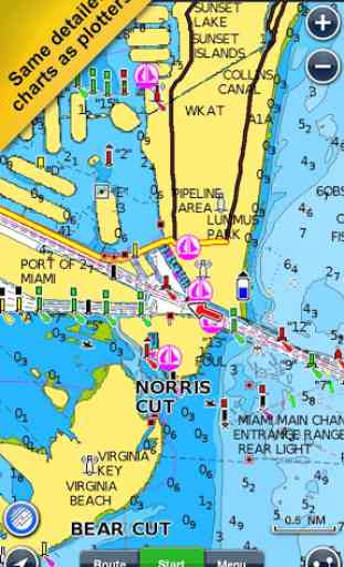
- NAUTICAL CHART for all essential cartographic reference detail. The most accurate and thorough set of information based on Hydrographic Office data, Notices to Mariners, new publications, our own surveys, and reports from users. It provides port plans, safety depth contours, marine services info, tides & currents, navigation aids and more.
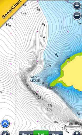
- SONARCHART™: the award-winning 1 ft/ 0,5 m HD bathymetry map that reflects ever-changing conditions. Be part of the community and contribute by uploading your sonar logs to enhance it.
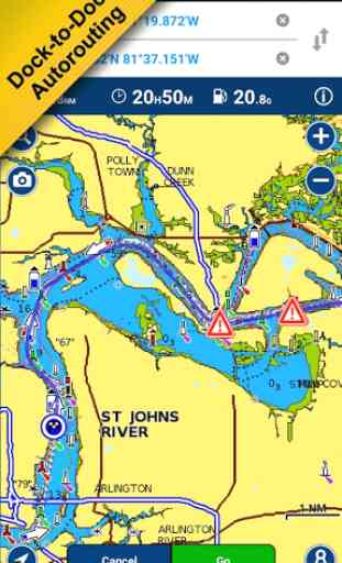
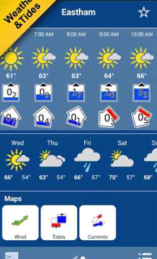
- COMMUNITY EDITS made by users (rocks, wrecks, etc.) and shared for all to benefit.√ CHART UPDATES: we deliver more than 2,000 updates every day! Take advantage of our updates as frequently as you like.√ ADVANCED MAP OPTIONS to highlight Shallow Areas and filter Depth Contours. Includes a Fishing Mode that enables Fishing Range for targeting key fishing areas. √ NAVIGATION MODULE for advanced route planning with ETA, distance to arrival, heading to WP, fuel consumption and more!√ DOCK-TO-DOCK AUTOROUTING quickly creates detailed routes even through narrow waterways and channels, based on chart data and navigation aids. POIs are automatically shown nearby your destination.√ WEATHER & TIDES provides real-time weather data and forecasts. Access daily and hourly forecasts for your favorite locations and get wind, weather buoys, Tides & Currents overlaid on your map.
Note: Download detailed maps by zooming in or from Menu>Download Map. Check navionics.com for coverage.Navionics+ is a one year subscription. At expiration you can renew with a discount of up to 50%. If you don’t renew, you can still use the charts you previously downloaded, along with several free features:
TRACK your journey, view speed, distance, time and COG. ROUTES: create and edit, based on speed and fuel consumptionMeasure DISTANCE, add MARKERS, get WIND FORECASTS and sun/moon cyclesMAP OPTIONS: Satellite/Terrain, adjust shorelines to selected Water Level, choose Depth Shading and Easy View to begin SYNC Tracks, Routes & Markers among your mobile devicesMAGAZINES & GUIDES for location-based articles from leading industry publishersSONARCHART™ LIVE
- allows you to create new personal 1ft/0.5 m HD bathymetry maps that display in real time while navigating. Upload your sonar logs to build even better local charts for your area connecting wirelessly to a compatible sounder/plotter.PLOTTER SYNC
- Compatible Wi-Fi enabled plotter owners can transfer routes and markers, activate and update their eligible plotter card and upload sonar logs for improved SonarChart™! Learn more at www.navionics.com/en/plotter-sync
Navionics has certified several Android models where the app is designed to load and operate correctly with an OS of 4.0 or higher. Please refer to our Compatibility Guide, which is continuously updated at http://www.navionics.com/en/compatibility/mobile. We cannot guarantee flawless operation or provide support for non-certified devices. ALL SALES ARE FINAL on Google Play.
Category : Travel & Local
Reviews (7)
Please add move to sd feature! Does not link with my Europe map. Call phones permission?!? Seriously, what were l are you thinking??
Crashes whenever I try to make a route. Even relatively short trips. I'll try know a few other devices. It that also crashed I'll request a refund.
Only issue that makes it not a 5 star app is that I get this crazy flickering when using heading up instead of North up. This got to be app software related since my other navigation apps are not suffering from this issue. Hope you can fix it ! Cheers..Update! The flickering is gone great and even more features. Looking forward to try out ETA and fuel consumption. 5 Stars deserved.
They fixed the app so now its great.
Works well on HTC One X, and the charts are updated regularly. It's great to have a backup for the GPS plotter. One wish is for the app to be able to import routes and waypoints from pc as it is difficult to be accurate on a phone.
The app is defective!It doesn't open!Don't waist your money.very disappointed
Why in earth would a navigation app need to access my manager my calls? EDIT: Call permissions have nothing to do with storage and photos. Also, making them runtime permissions (request them if and when user wants to use the app for phone calls) would mean that all users arent forced to give you access to their contact information . i.e. only to do so if they actually want to use that functionality