Boating Europe
NAVIONICS+ includes:√ Download of the following chart layers that will reside on your device even after expiration:
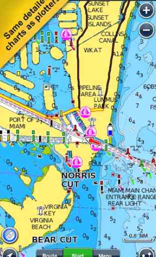
- NAUTICAL CHART for all essential cartographic reference detail. The most accurate and thorough set of information based on Hydrographic Office data, Notices to Mariners, new publications, our own surveys, and reports from users. It provides port plans, safety depth contours, marine services info, tides & currents, navigation aids and more.
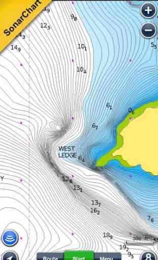
- SONARCHART™: the award-winning 1 ft/ 0,5 m HD bathymetry map that reflects ever-changing conditions. Be part of the community and contribute by uploading your sonar logs to enhance it.
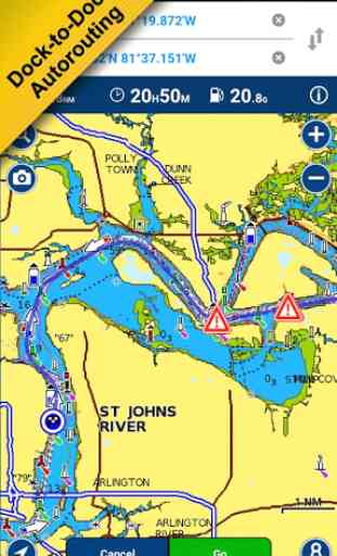
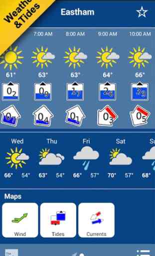
- COMMUNITY EDITS made by users (rocks, wrecks, etc.) and shared for all to benefit.√ CHART UPDATES: we deliver more than 2,000 updates every day! Take advantage of our updates as frequently as you like.√ ADVANCED MAP OPTIONS to highlight Shallow Areas and filter Depth Contours. Includes a Fishing Mode that enables Fishing Range for targeting key fishing areas. √ NAVIGATION MODULE for advanced route planning with ETA, distance to arrival, heading to WP, fuel consumption and more!√ DOCK-TO-DOCK AUTOROUTING quickly creates detailed routes even through narrow waterways and channels, based on chart data and navigation aids. POIs are automatically shown nearby your destination.√ WEATHER & TIDES provides real-time weather data and forecasts. Access daily and hourly forecasts for your favorite locations and get wind, weather buoys, Tides & Currents overlaid on your map. Buoy data is retrieved from NOAA and can include wind speed, gust and direction as well as air pressure, water temperature, wave height and other relevant marine data.
Note: Download detailed maps by zooming in or from Menu>Download Map. Check navionics.com for coverage.Navionics+ is a one year subscription. At expiration you can renew with a discount of up to 50%. If you don’t renew, you can still use the charts you previously downloaded, along with several free features:
TRACK your journey, view speed, distance, time and COG. ROUTES: create and edit, based on speed and fuel consumptionMeasure DISTANCE, add MARKERS, get WIND FORECASTS and sun/moon cyclesMAP OPTIONS: Satellite/Terrain, adjust shorelines to selected Water Level, choose Depth Shading and Easy View to begin SYNC Tracks, Routes & Markers among your mobile devicesMAGAZINES & GUIDES for location-based articles from leading industry publishersSONARCHART™ LIVE
- allows you to create new personal 1ft/0.5 m HD bathymetry maps that display in real time while navigating. Upload your sonar logs to build even better local charts for your area connecting wirelessly to a compatible sounder/plotter.PLOTTER SYNC
- NEW! Plotter Sync may also provide access to Dock-to-dock Autorouting, SonarChart Live and Advanced Map Options for your GPS plotter. Learn more at www.navionics.com/en/plotter-sync
Navionics has certified several Android models where the app is designed to load and operate correctly with an OS of 4.0 or higher. Please refer to our Compatibility Guide, which is continuously updated at http://www.navionics.com/en/compatibility/mobile. We cannot guarantee flawless operation or provide support for non-certified devices. ALL SALES ARE FINAL on Google Play.
Category : Travel & Local
Reviews (30)
Compared to the newer Boating HD app, this is a masterpiece... still missing the possibility to enter a direct position by inserting lat-long data...
I've just downloaded the Europe map but I can't see any detail on the chart its just blocks of land. How do I get the charts for the UK?
very useful for navigation and depth contours for fishing. Thank you
Good app but not always correct
I see that you plan to discontinue this app, what about us that we have paid for it?
This app is great if you use it on its own but if you let it connect to you main boat chart plotter it can realy foul things up, i lost most of my charts when it decided to gray most of them out! Very poor customer support. Leaves me trying to get my charts back on a laptop with a 3G data connection and big data bill!
Very handy and inexpensive GPS solution for small boats.
The app doesn't allow to store maps on sd card and one can't delete maps after downloaded them, all this a huge drawback.
Purchased app for use in UK a long time ago, now it has been split into multiple apps requiring a purchase for a different region and has a subscription cost.
They left me without support on sea for few days. Need to download promo app.
Best!
The best!!!
As a skipper i would give it 5 stars but recently i started to have issues with aplication. I bought it last season and it worked perfect. Last few weeks i cannot get reading for my position and speed of the boat. I'm looking forward to hear from Navionics team if we can work it out. Otherwise 5 stars!
Can not find a way to connect nmea0183 via network (not wifi, but cable connection)
both this app as Europe version and it doesnt include lreland maps,Ireland is Europe.Did instantly informed the app about that l got offer to buy Irelands map,also reply was like two weeks later,so was left with nothing but money was taken.
I have just purchased this app to aid in navigating the south coast of England however it does not include the UK. Surprising as it is definitely part of Europe. I purchased it in preference to the "UK and Holland" option, which was cheaper, in the belief it would give me a more complete coverage of the English Channel. So I am not happy with the purchase and would like to change it for the UK and Holland option if possible. How can an app entitled boating Europe not include England.
Look to be a very handy app, off to Greece sailing so i will be using, not sure if I would rely on it solely for navigation (but then thats true with any navigational aid) but as a back up and a first attempt passage plan then great, and getting an idea if passage times and a course great. Would like to see better way point management like place way point at Lat,Lon rather than just touchscreen. Overlay mode looks to be handy when mooring as it should give an idea what to expect at an unfamiliar port.
Good charts and much cheaper than a chart plotter
I have been using for several years now and never failed me
Very good for navigation
Love this app
I bought this app while i was in croatia with a chartdr sailing boat and wanted to use it for navigation. Unfortunately it kept crashing each time at startup. I cleared app data a cache several times tried reinstalling too but it just kept crashing on my nexus 7 tablet. I ended up buying the app again on my iphone. The android app was 44 Euros wasted. Id really love to get a reimbursement.
It was great app, up untill yesterday. It just syopped working on my phone (cats60) suddenly, won't even open. Tryed reinstalling it, farest i got is starting screen. Otherwise 5star app Edit: switched to 5stars, it would seem that my phone was the problem. Sd card was corupted, and extremly slow in loading data. Puting app in internal storage solwed problem. Thanks to navionics for quick reply!
I purchased this app this morning and so far I dont seem to have anything I did,nt already have for free. I have,nt got the funky looking charts as shown just the ones that look like there out of a cartoon. So far I am not at all impressed, far from it. Tried send this but it said rating required, there is,nt anything lower than a one star so its got to be -one star
Update after Navionics response: Thanks for getting back to me. I totally understand that the pixel c do not have GPS and there for the app won't work. This is clarified and solved. Perfect. No problem. This is not what this review is about. Again: I stated that I bought the wrong version. I have bought the phone version instead but should have bought the tablet HD version. This has nothing to do with the Pixel C or missing GPS. I have many times asked you about the fact that I waited 4 days to hear that I should have used another channel within 2 days. This you ignore every time.
The map swiping is often not smooth and it gets frozen for a second or two. Which makes it difficult to point to point of interests on the map. Moreover, sometimes pointing the + on a point of interest doesn't show it up, so you have to move randomly around it to finally have it appear.
Downloaded app, bought Europe charts but still not showing any detail when I open the app
It is the best for my androids
Great app and a bargain buy for sailors who want accurate, up-to-date charts. No more need to rely on those dodgy Russian charts I got off Ted. :) Update 2016. I used this App on my Samsung Galaxy Tab pro to navigate from Portugal to the Caribbean via Gibraltar, The Canary Islands, Cabo Verde then Barbados, St Lucia etc. Marvellous App. Didn't need anything else whatsoever. Recommended.
PLEASE NOTE: This app does not include Denmark as part of Europe. Make sure you look closely at the small figure about where the map covers. There are a number of overlapping map options and the supplier was not willing to swap maps.