Boating HD
NAVIONICS+ includes:√ Download of the following chart layers that will reside on your device even after expiration:
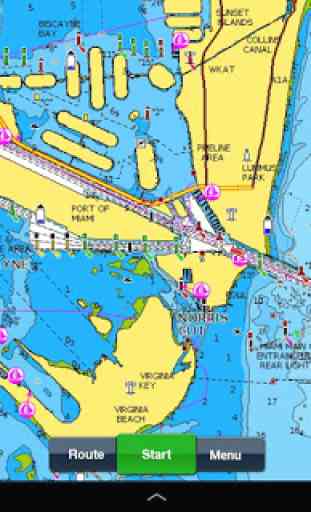
- NAUTICAL CHART for all essential cartographic reference detail. The most accurate and thorough set of information based on Hydrographic Office data, Notices to Mariners, new publications, our own surveys, and reports from users. It provides port plans, safety depth contours, marine services info, tides & currents, navigation aids and more.
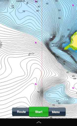
- SONARCHART™: the award-winning 1 ft/ 0,5 m HD bathymetry map that reflects ever-changing conditions. Be part of the community and contribute by uploading your sonar logs to enhance it.
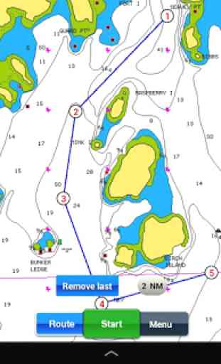
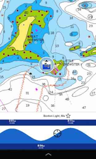
- COMMUNITY EDITS made by users (rocks, wrecks, etc.) and shared for all to benefit.√ CHART UPDATES: we deliver more than 2,000 updates every day! Take advantage of our updates as frequently as you like.√ ADVANCED MAP OPTIONS to highlight Shallow Areas, and filter Depth Contours. Includes a Fishing Mode that enables Fishing Range for targeting key fishing areas. √ NAVIGATION MODULE for advanced route planning with ETA, distance to arrival, heading to WP, fuel consumption and more!√ DOCK-TO-DOCK AUTOROUTING quickly creates detailed routes even through narrow waterways and channels, based on chart data and navigation aids. POIs are automatically shown nearby your destination. √ WEATHER & TIDES provides real-time weather data and forecasts. Access daily and hourly forecasts for your favorite locations and get wind, weather buoys, Tides & Currents overlaid on your map.Buoy data is retrieved from NOAA and can include wind speed, gust and direction as well as air pressure, water temperature, wave height and other relevant marine data.
Note: Download detailed maps by zooming in or from Menu>Download Map. Check navionics.com for coverage. Navionics+ is a one year subscription. At expiration you can renew with a discount of up to 50%. If you don’t renew, you can still use the charts you previously downloaded, along with several free features:TRACK your journey, view speed, distance, time and COG. Save to archive, see stats and playback ROUTES: create and edit, based on speed and fuel consumptionMeasure DISTANCE, add MARKERS, get WIND FORECASTS and sun/moon cyclesMAP OPTIONS: Satellite/Terrain, adjust shorelines to selected Water Level, choose Depth Shading and Easy View to begin SYNC Tracks, Routes & Markers among your mobile devicesMAGAZINES & GUIDES for location-based articles from leading industry publishersSONARCHART ™ LIVE
- allows you to create new personal 1ft/0.5 m HD bathymetry maps that display in real time while navigating. Upload your sonar logs to build even better local charts for your area connecting wirelessly to a compatible sounder/plotter. PLOTTER SYNC
- NEW! Plotter Sync may also provide access to Dock-to-dock Autorouting, SonarChart Live and Advanced Map Options for your GPS plotter. Learn more at www.navionics.com/en/plotter-sync Navionics has certified several Android models where the app is designed to load and operate correctly with an OS of 4.0 or higher. Please refer to our Compatibility Guide, which is continuously updated at http://www.navionics.com/en/compatibility/mobile. We cannot guarantee flawless operation or provide support for non-certified devices. ALL SALES ARE FINAL on Google Play.
Category : Travel & Local
Reviews (19)
This is so much better than when I first had a trial. No hesitation in paying for the annual subscription now. I'd like to see a tidal atlas that I can ffwd and rewind, and the weather and tides options are a bit clunky, but as a chart plotter it's near perfect *for me* in W Scotland. Startup could also be a bit quicker
After having this app for many years it has progressively gotten worse. It has known bugs that have been a problem for many months with no solutions. As with most Garmin products lots of bugs and lack luster support. Of course with the monopoly in this this industry there are limited options and it still tends to be better then Garmins Active Capt charting app.
Tablet memory is already full because Navionics removed the ability to save offline maps to an external SD card?? Also, the app does not show the vessel's (or the cursor's) active lat/long position at all times. If something happens, you need to be able to call out your lat/long position, IMMEDIATELY. You can't be fumbling about pressing a question mark and then reading tiny print to find the vessel's current position!
Great except when it comes to relief shading. It's super clear in some places, but it's blurry in other places. My fishing spot is cut in half, one side with great detail and then it's not clear. It look as though it hasn't downloaded properly.
Navionics saved me from running aground near Marco Island Florida. The charts in my plotter, although up to date, were off several feet on sounding. I believe that because of crowd-sourcing the area we were traversing, known for shifting sand, must have been updated in navionics and not in the plotter.
Absolutely a great app. I would give it five stars if I was able to store the maps on my SD card in the phone instead of chewing up all of my internal memory. Any chance that can be on the drawing board for a change in the near future? Unless you already have that feature but I have looked and looked.
I paid for this app a few years ago. Now its a subscription? I don't care about the cost, but they changed the terms, and now I'm on the hook for more $$$. Good maps though. Edit:. Was never able to restore my purchases, tried when this review was written originally, tried again today.
Mapping information is top notch, but the app is clunky and very in your face. The navionics web app is much better, but has features missing that I would pay for. Has gotten much better...
Was getting ready to leave on my sailboat yesterday had planned a route for my voyage, got on the boat tried to open the app... nothing. Couldn't log in, couldn't even download anything. Failed me when I needed it the most. Loved it until yesterday, thank goodness I somewhat knew where my route was taking me. I pay money for this not to fail...
Use to be a really good app until someone there or a team there decided to update the app to basically make it unusable. I can no longer get the autoroute to work. it basically just draws a straight red line from my starting point to my end point. The autoroute feature was a primary feature why i purchased the app. Since it no longer works for me do you have an idea when this might be fixed... if there is no fix in the works is it possible to get a refund for the app. Again, it was a really great app and I would have given it 5 stars a month or so ago, but now I don't think anyone should be purchasing it at this time.
12/21: Latest update lost all my charts. 10/20: So many bugs - Navionics has been having tons of quality issues in the last year, to the point where I'll need to switch charting apps. The latest bug is it's pretty much unusable on Android 11 because the map tiles render extremely slowly. They also have a long standing bug where it crashes when viewing tide levels. Other bugs are related to losing your navigational maps when the app hasn't been connected to Internet on a while.
Finding on multiple lakes the depth on the map is significantly different than the actual depth. I understand there is a little margin of error and changes in the lake level. But have had the map say it's 35 feet and actually depth is 20 feet. Not good if you're paying for this app. Maybe time to look at other methods.
Absolutely the worst UI and UX of any app I've ever used. No intuituve or functional design. No night mode for night use. Do not waste your time or money.
Unhappy I cannot use this as I have money invested into maps and hardware to use this app. Been fantastic all summer, opened up yesterday and reset my cache, restarted phone and the app will still not load. Hangs up on "loading" screen.. would be willing to provide any diagnostic data I can. Edit: I appreciate the quick response and solution. Reinstall fixed the issue, however my sonarcharts were erased and lost days of charting. Hopefully this was only a local issue, not caused by the app.
Frustrating, app has random issues everytime I open it. The latest is no external storage please insert sd card. I have and have always had an SD card inserted and even formatted it to see if it would work and the error continues. When it works it's a very useful app for saving point from trips with others or for ice fishing or scouting. When it works.
Junk.I have purchased two Navionics maps both times after a new phone purchase and neither app will load.I am told the apps I purchased are no longer supported,that is fine because both maps worked great until the phone swap.So now I have purchased 2 worthless apps lost all of my markers and Navionics wants me to purchase another app.Get bent..
Very useful but missing some important features such as the ability to control info boxes and co/distance on routing lines. Lots of errors in SC like Charleston FW missing.
Don't pass up the opportunity to not only just see contour and topography but to understand the movement of the water as well. Free is fantastic you can't get anything better at least you're not holding topography maps anymore and scrolling through a book of lake maps but the premium is by far the most worth it thing you can have as a fisherman. It's not filled with bullcrap and blogs and opinions this is a data first information gaining app. I'd recommend taking the time to learn the app. 🤙🤙
I've used this the past 2-3 years and it's been great! Opened it up this week to plan for the summer, and the updates since last summer have made it freeze consistently. I literally can't even sign in anymore. I've also tried other phones- same issues. Please undo the changes you made! It's unusable. Very disappointing.