Boating UK&Holland
NAVIONICS+ includes:√ Download of the following chart layers that will reside on your device even after expiration:
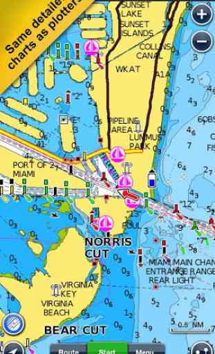
- NAUTICAL CHART for all essential cartographic reference detail. The most accurate and thorough set of information based on Hydrographic Office data, Notices to Mariners, new publications, our own surveys, and reports from users. It provides port plans, safety depth contours, marine services info, tides & currents, navigation aids and more.
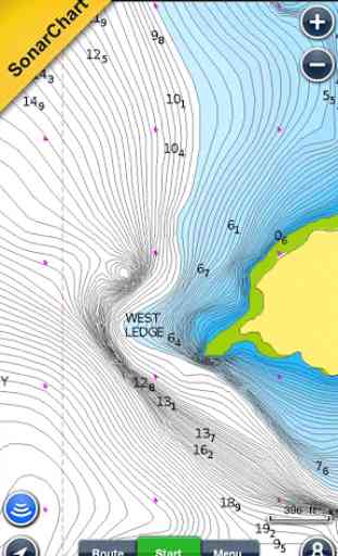
- SONARCHART™: the award-winning 1 ft/ 0,5 m HD bathymetry map that reflects ever-changing conditions. Be part of the community and contribute by uploading your sonar logs to enhance it.
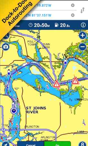
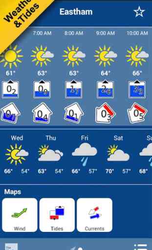
- COMMUNITY EDITS made by users (rocks, wrecks, etc.) and shared for all to benefit.√ CHART UPDATES: we deliver more than 2,000 updates every day! Take advantage of our updates as frequently as you like.√ ADVANCED MAP OPTIONS to highlight Shallow Areas and filter Depth Contours. Includes a Fishing Mode that enables Fishing Range for targeting key fishing areas. √ NAVIGATION MODULE for advanced route planning with ETA, distance to arrival, heading to WP, fuel consumption and more!√ DOCK-TO-DOCK AUTOROUTING quickly creates detailed routes even through narrow waterways and channels, based on chart data and navigation aids. POIs are automatically shown nearby your destination.√ WEATHER & TIDES provides real-time weather data and forecasts. Access daily and hourly forecasts for your favorite locations and get wind, weather buoys, Tides & Currents overlaid on your map. Buoy data is retrieved from NOAA and can include wind speed, gust and direction as well as air pressure, water temperature, wave height and other relevant marine data.
Note: Download detailed maps by zooming in or from Menu>Download Map. Check navionics.com for coverage.Navionics+ is a one year subscription. At expiration you can renew with a discount of up to 50%. If you don’t renew, you can still use the charts you previously downloaded, along with several free features:
TRACK your journey, view speed, distance, time and COG. ROUTES: create and edit, based on speed and fuel consumptionMeasure DISTANCE, add MARKERS, get WIND FORECASTS and sun/moon cyclesMAP OPTIONS: Satellite/Terrain, adjust shorelines to selected Water Level, choose Depth Shading and Easy View to begin SYNC Tracks, Routes & Markers among your mobile devicesMAGAZINES & GUIDES for location-based articles from leading industry publishersSONARCHART™ LIVE
- allows you to create new personal 1ft/0.5 m HD bathymetry maps that display in real time while navigating. Upload your sonar logs to build even better local charts for your area connecting wirelessly to a compatible sounder/plotter.PLOTTER SYNC
- NEW! Plotter Sync may also provide access to Dock-to-dock Autorouting, SonarChart Live and Advanced Map Options for your GPS plotter. Learn more at www.navionics.com/en/plotter-sync
Navionics has certified several Android models where the app is designed to load and operate correctly with an OS of 4.0 or higher. Please refer to our Compatibility Guide, which is continuously updated at http://www.navionics.com/en/compatibility/mobile. We cannot guarantee flawless operation or provide support for non-certified devices. ALL SALES ARE FINAL on Google Play.
Category : Travel & Local
Reviews (30)
Very poor, just because you stop the support of the app you shouldn't make it impossible to open blaming the internet connection. This could put people and craft in danger . Any old trick to get some more coin I suppose.
I get so tired of this. For me, it's now time to move away from Navionics and towards OpenCPN. I've really enjoyed using Navionics, and it works great. The problem is that their business model is to charge you for the software, and then they mothball it and bring out a new, indistinguishable version that you have to buy again, for more. I think it's outrageous, and what it really needs is a class-action law suit. I've had enough of it...
Ok until latest update when it switched into SonarChart mode without warning. It took me ages to figure out what the problem was. Yachting forums were far more help than Navionics support who seem to be script-readers and don't know the product very well. I get the impression from other reviews that Navionics are more interested in features than stability and quality.
Loved it until the recent update made all sonar chart readings disappear. Badly need them for fishing. Can you help me please.
I was sold this system for inland waterways of Europe. It is not at all useful. Does not give bridge heights or navigation information for canal system. Wish I had bought PC Back to now.
Love it.
Excellent when it is working, but updates sometimes block this app. The primary requirement of a marine navigation app is that it is reliable and unfortunately Navionics fails in this respect. Typically the last update requires a sign-in and agreement to new privacy policy and T&C but the code is badly written and the app crashes. However the guys at Navionics were on the ball and within 48 hours the bug was fixed. Much impressed thanks Navionics.
Beautifully presented app
New version of app seems to have whole area arround Nav Tower removed from Sonar Chart. Very disapointed. That wasnt made clear before purchase. Buyer beware crookery afoot
Just started to learn to sail, so I dicided to download and try this very popular app. I love it and have complete confidence in it. Its so helpful. Great Stuff
Loved this app until my subscription ran out. Follow the links to renew and it doesn't work. Shame as it's normally a brilliant app and I used it all the time.
Yes great app
A good application ruined by nagging reminders to update your plotter etc. There is a tab for later but none for don't ask me again.
Really supburb app to have while sailing in fog. Perfect for everything you need
App crashing when trying to do automatic routing.
Do not update your app as it had buggered up the routes information tab and now I cant see any information about my stored routes and just has a message saying about auto routes and thats it. Ive told support but still no response!
I wish it could show AIS targets from NMEA. Also it would be really nice if I did not have to pay twice for HD and non-HD charts.
This is more useful than my new B&G Zeus 2 chartplotter, with Navionics Plus. An excellent app.
Works well for planning in conjunction with a wide area chart when ashore away from the chartplotter. Also useful on board as a backup.
I struggle to find fault. Used for a number of years for passage and pilotage all over the south west.
Why have ads popping up in the paid version. Annoying and not necessary
I purchased skagerrak and kattegat in the boating application of navionics. I m downloading areas but why i cant see the maps? I installed application again and restored purchases; but still i cant see the detailed maps :((( why i cant use my maps in one application grrrrrr
I bought this as a reference and back up and everytime I have had it running it has been accurate and reliable. Eats the battery a bit but to be expected. I looked at installing isailor as it has useful functions like EBL/VRM and vessel dimensions for a ship shape but for what I use it for the cost of the charts is exorbitant. This gives me full coverage at a much better price. If you put in the above functions it would be unbeatable. One off cost for the charts, optional annual fee for updates and sonar.
I downloaded this app as I'd seen it used to plan routes on an iPhone. Unfortunately I have a Samsung Galaxy S7 edge. So I don't have the same options available to plan a dock to dock route. If there was an update to bring this option in I'd give it more stars. I would like to have the route mapped out the same way it's done with an iPhone rather than long tapping points. Thank you
I bought the app in December 2013 and it worked great for a month or so then I have been without the app for 8 months finally with Navionics technical team working on the app it now works fine. Ive been using the app now for several years and its always getting better.😆
Would have given this app five stars until the last update, the app just does not work anymore, I also had a surprise request for payment for my "annual subscription", I first started using this app over 3 years ago and have never been asked to pay for an annual subscription before and this came with no explaination
Good app for emergency and for electrical power saving under sail. Only drawback is that unlike nearly all other map and chart apps it does not permit its large map data download to be stored on the external SD card of my Sony Z3 waterproof tablet so it limits other apps.
First class kit, keep it updated for best results
Used regularly for many years. Recommend
The app it's self is great, but I am annoyed by the lack in clarity of subscription cost! If I buy a new region, do I only have to pay for the renewal of one navionics+ subscription, or do I have to pay yearly subscriptions for each region I buy? Does buying new regions increase my yearly subscription cost? I have been searching for the answer for an hour now, and can't find it anywhere. you should really make it more clear.