
Boating US&Canada HD
NAVIONICS+ includes:√ Download of the following chart layers that will reside on your device even after expiration:
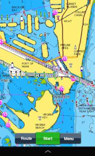
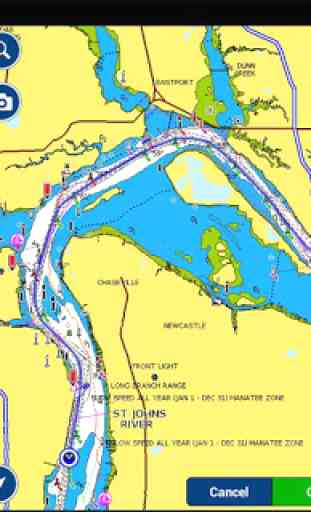
- NAUTICAL CHART for all essential cartographic reference detail. The most accurate and thorough set of information based on Hydrographic Office data, Notices to Mariners, new publications, our own surveys, and reports from users. It provides port plans, safety depth contours, marine services info, tides & currents, navigation aids and more.
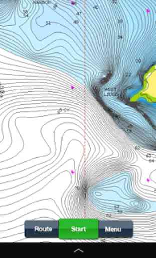
- SONARCHART™: the award-winning 1 ft/ 0,5 m HD bathymetry map that reflects ever-changing conditions. Be part of the community and contribute by uploading your sonar logs to enhance it.
- COMMUNITY EDITS made by users (rocks, wrecks, etc.) and shared for all to benefit.√ CHART UPDATES: we deliver more than 2,000 updates every day! Take advantage of our updates as frequently as you like.√ ADVANCED MAP OPTIONS to highlight Shallow Areas and filter Depth Contours. Includes a Fishing Mode that enables Fishing Range for targeting key fishing areas. √ NAVIGATION MODULE for advanced route planning with ETA, distance to arrival, heading to WP, fuel consumption and more!√ DOCK-TO-DOCK AUTOROUTING quickly creates detailed routes even through narrow waterways and channels, based on chart data and navigation aids. POIs are automatically shown nearby your destination.√ WEATHER & TIDES provides real-time weather data and forecasts. Access daily and hourly forecasts for your favorite locations and get wind, weather buoys, Tides & Currents overlaid on your map. Buoy data is retrieved from NOAA and can include wind speed, gust and direction as well as air pressure, water temperature, wave height and other relevant marine data.
Note: Download detailed maps by zooming in or from Menu>Download Map. Check navionics.com for coverage.Navionics+ is a one year subscription. At expiration you can renew with a discount of up to 50%. If you don’t renew, you can still use the charts you previously downloaded, along with several free features:
TRACK your journey, view speed, distance, time and COG. ROUTES: create and edit, based on speed and fuel consumptionMeasure DISTANCE, add MARKERS, get WIND FORECASTS and sun/moon cyclesMAP OPTIONS: Satellite/Terrain, adjust shorelines to selected Water Level, choose Depth Shading and Easy View to begin (not on Govt. Charts)SYNC Tracks, Routes & Markers among your mobile devicesMAGAZINES & GUIDES for location-based articles from leading industry publishersGOVT. CHART in USSONARCHART™ LIVE
- allows you to create new personal 1ft/0.5 m HD bathymetry maps that display in real time while navigating. Upload your sonar logs to build even better local charts for your area connecting wirelessly to a compatible sounder/plotter.PLOTTER SYNC
- Compatible Wi-Fi enabled plotter owners can transfer routes and markers, activate and update their eligible plotter card and upload sonar logs for improved SonarChart™! Learn more at www.navionics.com/en/plotter-syncCOVERAGE
- Does not include Bermuda, which can be found on Boating Caribbean & South America. Visit navionics.com for the lake list.
Navionics has certified several Android models where the app is designed to load and operate correctly with an OS of 4.0 or higher. Please refer to our Compatibility Guide, which is continuously updated at http://www.navionics.com/en/compatibility/mobile. We cannot guarantee flawless operation or provide support for non-certified devices. ALL SALES ARE FINAL on Google Play.
Category : Travel & Local
Reviews (26)
Absolutely the most annoying app on my phone , need to spend 5 min each star up clicking " Not now" to upgrades you don't ever want
As a pro yacht and ship Captain, this app is indispensable for route planning and backup.
Always dependable and accurate !!!
SOL if you don't have internet while at sea ...
I downloaded this so I could boat safely into some of my fishing spots with my new boat. I cant seem to get any details on the lake that I want to fish. When I try to download maps it just says requesting maps and nothing happens. Waste of money.
When I down loaded the US and Canada HD App. I only got a lower inside part of Vancouver island to Seattle WA. Why?
Used to be great. Now cant change dates on current stations on android (well, you can change the date, but it just gives you today's currents) so downgrade to 3 stars. Oddly you can still change the date on the tide stations.
Downloaded this app to my tablet since I was going to be using a buddies boat and he did not have a GPS installed. I put my tablet in one of those waterproof bags made for electronics and along with his cheap fish-finder, we were good-to-go. One major thing I found missing, that would be on a "real" GPS unit, was a specific "Mark" button. I kept thinking that there must be an easier way to add a mark. I'm in the habit of hitting the "Mark" button on my Humminbird when I hit a fish, especially when fishing new areas, to determine where fish maybe holding to structure. On my unit it automatically applies a label with a number and the numbers increment by one each time or you can change the label. It took me quite some time on the water with this app just to figure out how to add a mark. Once I finally figured that out, it was not an easy process to do it quickly. Because it takes as much time as it did, I often had to land the fish first, then try to add the mark and by that time I was quite a distance from when the fish hit. Seems like an instant "Mark" button (pushpin shaped!) would be an easy thing to add. Otherwise, it worked very well!
Love this app... or rather the outstanding chart detail. I have used others charts before finding Navionics! Love charts, details, and Bath charts, great for fishing and exploring new coves... Get it, you'll love it too! Great choice of Worldwide charts...
I use this app on two different devices and it keeps showing that the subscription expired on one of them. And it doesn't yet have Doc to Doc routing!
Update...synching data seemed to be the final fix. Working well now. Not crashing any more as reported below............... Still crashing when zooming out. Tried everything, cleard cache, freed ram, used the +,- to zoom, used pinch to zoom, zoomed in small increments, zoomed in large increments...always locks up and then crashes after about 5 zooms. This renders the ap useless.
Used it exclusively to sail from Smiths Falls to Lake Ontario, New York side to Montreal to Ottawa back to Smiths Falls. Use to use a Garmin 60 c and it died the replacement would have been $700 it is now swiming with the fishes. Bottom line is how acurate is your device's gps or how accurate do you need? My Tab 8 is about one boat length acurate (26') As for water profing I use a high end freezer bag.
Good app. Used it from Prince Rupert British Columbia to Newport Oregon... about 1500 miles. I only have one complaint, but is a rather large one... there is no function or option to constantly display your current lat/lon. The only way to display your position is to push and hold the screen,and even then unless you are zoomed all the way in you don't get a precise reading. This is an essential function on any plotter and would make this app a 5 and worth every penny.
I uninstall the app and reinstall and keep getting"input/output error" How can I resolve this? I want to use the app.
Within 2 weeks of the marks being deployed they were available on your carts.
Highly recommended. But don't rely on it. Paper charts will always be better and more reliable. Good for planning ahead and safe short sailing. Please don't depend on this app when on unknown waters or long excursions. For your own safety and others'.
Can not zoom in close enough to use properly. For $55.00 it should be able to zoom in much closer.
I got the new update ... nothing new really. Come on guyssssss do something for Android too. You make me buy an ipad, and i hate apple.
Was happy until last week when the ap stopped. Installed the update. Now unstable. I use this to nav my sailboat. What's the deal?
Latest update keeps having a fatal error. Have uninstalled and reinstalled 5 times. No longer works. Was completely fine before this. Need either a roll back option or bug fix please. I depend on this app.
Great app. it would be better if you could edit a route by dragging the waypoints though.
Wifi. Required....not good for remote areas
I like the look and feel of the app but I would really like to see the ability to edit routes on the android version. I'd also appreciate a course up mode when underway.
Loved it at first but now it unexpectedly closes every time I try to use it. Have a fishing trip this weekend and can't access all the spots I marked. Not working on my phone or my tablet.
Very useful app. Perfectly complements the chart plotter, much easier to carry around than the plotter. The UGC is very helpful as well
Used to be good. Company got greedy. Dumped their current paid customers for the "better subscription service". Just a money grab until the next business case is better. Then they will discontinue the subscription service for the next thing that makes more money. Typical. Screw the customer and make more money.