BRouter Offline Navigation
See http://brouter.de/brouter for more documenationSee http://brouter.de/brouter-web for an online version.
**
* If you do not know one of OsmAnd, Locus-Maps or Oruxmaps, then the BRouter-App is useless for you. Download only if you are willing to spend some time to understand the setup. No one-star reviews from the unpatient please! email for problems ***
BRouter does only the plain route-calculation and does not display a map or the calculated route on it's own and therefore works only together with a Map Application. There are two different methods for the interfacing between BRouter and the Map application: BRouter offers a service interface that is called by the map application without a need to start the BRouter-App. This way, BRouter is a routing service very much like an online routing service, including dynamic recalculations if you get off the track. The other mode of operation is to start the BRouter-App and use waypoints from the map application's waypoint database to define your route. The calculated route is then written as a GPX file (including the elevation profile) to the map-application's tracks directory.
Locus and Oruxmaps and OsmAnd support both the service interface and the interface via the wayoint database in their current versions available on Google Play.
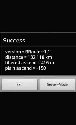
The service interface uses a timeout of 60s, limiting it's use to distances of about 50km, but using the BRouter App you are able to calculate much longer distances. But even long-distance tracks can be followed via the service interface (including dynamic recalculations). This is done by pre-calculating a route for your destination once using the BRouter App and assigning it to a routing mode via the "Server-Mode" Button. This feature is called "timeout-free recalculations".
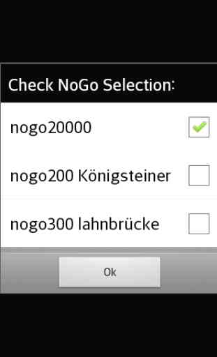
The route calculation, no matter if via the service interface or via the BRouter App, also considers nogo areas that can be defined as waypoints with a special naming convention (e.g. "nogo200" for 200m radius). This way it is possible to account for actual obstacles, but this feature can also be used to enforce personal preferences.
BRouter contains a download manager that assists downloading the required routing data files.The download manager is called on the first start of the app, and later on it is offered if internet access is available.
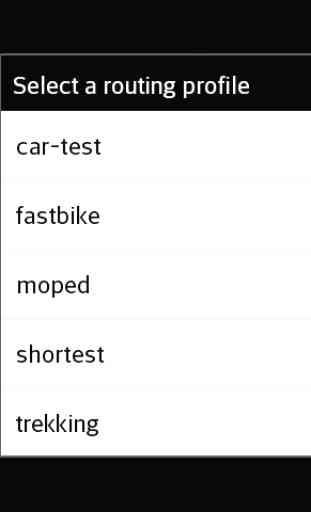
The mapping from one of the 6 routing modes (car/bike/foot
* fast/short), that are used traditionally by routing services, and BRouter's concept of fully configurable routing profiles get's the following default mapping after the installation of BRouter:
car-fast -> car-testcar-short -> mopedbike-fast -> fastbikebike-short -> trekkingfoot-fast -> shortestfoot-short -> shortest
This mapping, however, can by changed anytime via the "Server-Mode" Button of the BRouter App. But also the routing profile definitions can be changed or new ones can be created.
Routing for cars is is currently available only in an experimental state ("car-test") and is not recommend. For example, turn-restriction are not taken into account.
Category : Maps & Navigation
Reviews (29)
Great utility app. Sometimes you just wonder where they got the routing data from, especially in the woods. On the other hand, in very few cases it finds a path that is barely there (in said woods), so take the info with a grain of salt.
How it works: define starting point and destination in a map viewer (e.g. Oruxmaps), then open the BRouter app, pick up your starting point and destination from there again, then choose from about 8 different routing styles (e.g. mountain-, trekking-, road-, recumbentbike). A gpx file with your route is generated that you can then view and follow in (e.g.) Oruxmaps. I used this in Southeast Asia, Eastern Europe and Germany, mostly for long road and trekking bike-style routing. It worked very well, a loooot better than Garmin (gpsmap 64s) handheld GPS onboard routing and still better than Google maps bicycle routing. Thank you for this extremely useful app.
The BRouter Web Application is great, but this Android App does not work at all. I can download maps, and that is it. Because I have Android >6 and that (according to the help) means I must choose "Server-Mode". After doing that, I can choose a vehicle profile and then the app just exits.
My prefered routing service for my prefered navigation software (Locus Map Pro) Has working fine on my older Sony and Xiaomi smartphones, and is OK too now with a One Plus 6T, but strangely, is no OK with my previous One Plus 3T, so I use GraphHopper as routing service on this one.
Excelent app, I can't believe this is free. Works great with Locus Map.
Well written, well supported, and operates well. Definitely adds some benefits to OsmAnd. Is excellent because it works offline, as does OsmAnd. Keep up the good work.
As the author says, you need to invest time to get to know the application, but I have found the investment pays dividends in taking me on some great cycling routes. Great for cycle touring.
Used it with Locus for offline navigation in several situations. Perfect. Perfect for hiking as for driving.
The app is ugly but if you want interesting cycling routes other than the same old boring ones from Google, komoot or strava, this is the place to go.
Provide offline routing for tracing hiking routes using LocusMap. BRouter is really a god send. I use it even when there is Internet connection. Thanks.
Excellent for bike routing and especially useful as a plugin for OSMAnd
Routing is great, the UI is almost unusable though.
excellent routing app that I use in combination with Oruxmaps offline GPS app for hiking
Experimental interface but does it's job brilliantly!
Really great routing engine, but ugly UI.
Worked before but now unable to download England segment due to java error..
Used with Locus Maps to calculate navigation.
Bicycle routing is top notch.
A must for offline route creation. works brilliantly in Locus Pro.
Works great with locus pro
works great with C:geo
I have been using this application for several years! It is not as easy to use as the online version but it is still the best alternative when your out on your bike and need a route! Could it be more user friendly - yes. do you need some time until you understand all the option - yes. But I am grateful that it exists in the first place. Keep Going!! (I am using it in combination with orux-maps)
Works for me with Locus map but not with OsmAnd which is a shame because I much prefer OsmAnd. Maybe it's just me not configuring it properly but the instructions are very confusing.
Great for off road touring. My first choice router!
Help please Have New phone with Android 7.0, the app doesn't work anymore with oruxmaps! What can I do?
Brilliant, have been using it for hiking and trekking in several countries (as a Locus map service) and it works great. The app itself, in "download" mode looks a little rudimentary- but makes the job well done anyway. Perhaps adding an option to auto update the downloaded tiles, or at least check and notify if the data has changed since last download?
A very useful complement/plugin for various offline maps such as locus and osmand. Make sure to download the sector where you need the routing capability. When navigating and internet goes stoneage, you should have this as one of you alternatives. Take note that it doesn't know all one-way (under construction roads like waze does) but it should give you an idea of the routes to take esp on far flung areas. N00BS who will be using this, read first how to use before whining--use some brain cells. Ciao!
Does not work anymore: "missing data file for offline routing", despite I downloaded my area of interest
I like how I can customize the routing. Unfortunately, I forgot to grab my custom profile and it's rather excruciating to really fine tune. I had the perfect blend of using high quality bike paths to street paths while minimizing distance and elevations, and I've never had another profile do that. Took me DAYs to perfect that. Sigh... Still highly recommended!