Buckeye Trail
Thru-hikers, day hikers, volunteers, friends and family, future hikers, or arm-chair hikers and trail enthusiasts will all find something useful.
For Hikers:
• Most up-to-date trail and town data crowdsourced by thousands of hikers. See water reports, snow conditions, stream crossing water levels, bus schedules, restaurant and lodging reviews, and more.
• Any user can add waypoints, photos, comments, update descriptions, and edit any content in the app, in real time. Think Wikipedia!
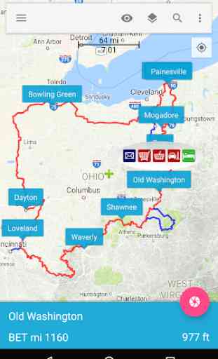
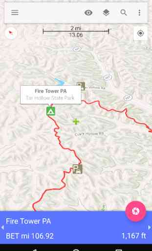
• Download topo maps, road maps, and satellite images for offline use.
• Navigate using GPS while in Airplane mode. Everything in the app works while offline after the initial data download.
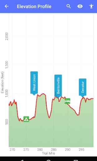
• View elevation profiles and compute distances to locations along the trail.
• Share your location (optional) and see where others are on the trail.
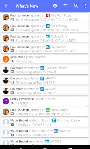
• See a real-time feed of contributions other hikers are making.
• Search the map by name or point type, search the activity feed by hiker name, location, or type of edit.
For Friends and Family:
• Track the location of your hiker on the trail.
For Trail Maintenance Crews and Land Management Agencies:
• See real-time hikers reports of trail damage, blowdowns, and infrastructure maintenance needs (e.g., washed out bridges).
For Future Hikers and Trail Enthusiasts:
• Explore and learn about the trail. See current photos, use the wealth of information and hiker reports to plan your hike and resupply stops.
The Buckeye Trail is part of the HikerBot family of apps. We also have apps for the following trails: Appalachian Trail (AT), Pacific Crest Trail (PCT), Continental Divide Trail (CDT), John Muir Trail (JMT), Sierra High Route (SHR), Great Divide Mountain Bike Route (GDMBR), Continental Divide Singletrack Trail (CDST), Hayduke Trail (HDT), Wonderland Trail (WT), Arizona Trail (AZT), Superior Hiking Trail (SHT), Theodore Solomons Trail (TST), Bibbulmun Track, Coast To Coast Track, Pacific Coast Trail.
Category : Travel & Local
Reviews (8)
Had high hopes for this app, but it's disappointing. The trail download was excruciatingly slow. After 24 hours, it had downloaded less than 25%. Because there were some positive reviews, I decided to pay $5.99 for the unrestricted map download. Boy, do I regret it, now. Although the map downloaded quickly, the trail never did! after two days, and two reinstalls, I'm still waiting! two emails to tech support, and no response! do not bother with this app!
Loaded and tried to use but wouldn't connect to a server to update/add points. Description indicates it hasn't been updated since 2018. Guess it isn't supported anymore. I'll use the Guthook app instead.
This used to be very good it used to also show The full buckeye trail now it doesn't show anything
takes up way too much space, cant even use it
solid app! Ive used it several times while hiking on the BT amd it is great!
Multiple ways to break this app. Can't add waypoints without breaking. Once sat view is selected, no way to revert to normal view. I want this app to work right, but it doesn't. Once it breaks, you have to uninstall and reinstall, which takes about a half hour.
Same great hiking app I used on the Appalachian Trail, with Buckeye Trail data preloaded. Awesome app!!
Thanks to Hikerbot for a great App! I used this for about 400 miles on the Buckeye Trail and it was super helpful. I was misplaced way less than the journals of a few past hikers I was following along with! Just a warning, the GPS data I believe reflects the same data as on the BTA website which is from 2012. There were only 2 instances during my 400 miles where the App data differed significantly from the maps. Just be careful as the App data does differ a few times from the current routing. I did struggle a bit getting the App loaded and maps downloaded, I learned to be patient and ignore the status bar and eventually it would finish the process.