BusBahnBim
BusBahnBim works simply by address input and always uses the most up-to-date data. For example, the current traffic situation can also be included, including construction sites, congestion, delays, diversions, etc. Also stop-call names are no longer necessary for the query, by activating the GPS-positioning, the current location can be used as the starting point. Optionally, the desired destination address, a street name or point of interest can be used.
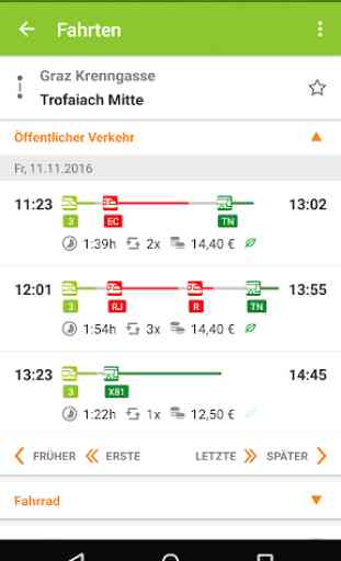
The BusBahnBim App allows quick, uncomplicated information, a realistic comparison of the time involvement of different modalities, clear maps and charts to the orientation offer and fascinate with a modern design. A favorite choice, dispatch of the connection and info via e-mail or SMS, storage of the departure times and arrival times in the calendar are other useful features.
Overview of the functions of the BusBahnBim App:
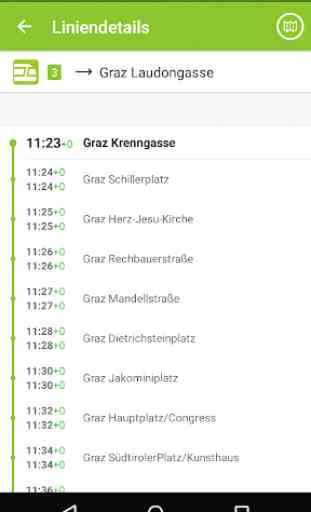
· Stop search via GPS
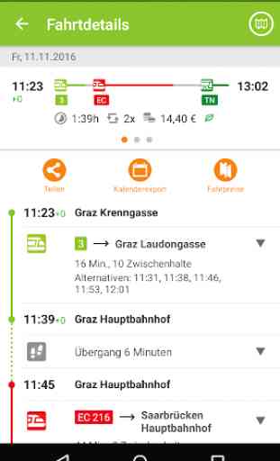
· Journey proposals incl. time involvement
· Connecting dispatch via e-mail or SMS
· Memory possibility with reminiscent function in the calendar
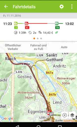
· Clear map representation by high-resolution map
· Define your own favorites
· Intermodal comparison between public transportation, foot / bicycle routes and motocar routes and the time involvement
· Monitor announcement for an elective stop
Description of permissions:
· Camera:
Allows the user to take a photo for a personal take-me-there favorite in the trip planner.
· Contacts:
Enables that the usage of contacts/addresses from the users phone book for searching (e.g. input of start or destination in the trip planner or searching via map view).
· Location:
Network-based locating or locating via GPS enables routing to or from the current position.
· Have full network access:
Is necessary for internet access of the app.
· Install shortcuts:
Enables the user so save shortcuts on the home screen of the device.
· View network connections:
Allows the app to check the status of the internet connection (access yes/no, type of connection (wifi, mobile data etc.)).
Category : Maps & Navigation
Reviews (28)
I use it almost every day and it is always correct. In order to reach a train one should be careful to add at least 10 minutes to what the app suggests. In other words: take the earlier bis or tram connection. The response to one complaint was very polite and helpful.
This app is really useful for traveling by public transport. However, the fastest routes and options aren't always shown.
I use public transport often, however not at regular basis. I find it very easy to look up connections, possibilities. Price infos are available in the app.
very helpful and time consuming...I see the timing of next bus or tram on this app and plan my schedule easily. Also it sometimes help me to find the best possible route to access my destination.
I like this app is helpful.
Good for the schedule within the city range. But not effective when you travel to places outisde the city and around
When Google Maps was unable to give us the correct information about public transport, this application has helped us with the right information about routes and schedule.
Very accurate with routes and time. Used it in Graz and in Vienna. Wonderful application.
I am new to Austria in general and this App help me so much in my daily life. It is easy to understand and everything is clarified. So i give him 10/10.
Best regional transit info app. If you also want to buy tickets, try "Wegfinder"!
Not working with newest Generation of Samsung Phones (e.g. Flip 3) App crashes immediately after opening.
I really like the possibility to adjust the transfertime!
It's really good but I'd like to enter the date and time to like optionally.
I like the app its very accurate and useful also working everywhere in Austria.
great app, using it everyday, fast, accurate, reliable
Awesome App, I use it everyday and it does exactly what it's supposed to do. +5
Indispensable if you are living in Austria and using public transportation.
The way too slow
Essential in day to day life in Graz. Very well executed.
Love it. The devs did their best.
Very good ,and I am interesting.
Just in time ⏲️
Love it
Very accurate, and often even contains info about early/late stops, which is really useful. Walking speed for time calculations to and from stops can be changed to 3 different levels and is very accurate when configured properly :)
Essentially perfect. I use the app for most routes (especially the Walk feature, since it seems to load more efficiently than e.g. Google Maps). What would be extremely practical is an „intermediary stop" option for addresses (not just public transit stops).
gut wallah
Sometimes updates when buses/trams are delayed, sometimes doesn't. Would be good to include the number of the bus/tram that's the alternative too Other than that an amazingly useful app, would recommend to anyone as I'm nitpicking!
Wie angefragt betrifft das die Linien 3 und 5 Abfahrtszeiten Tabellen in der Station stimmen nicht mit den Zeiten der App überein. In der Zwischenzeit probieren ich mal Graz Mobile App aus ~ ich hoffe die sind besser. Departure times for Tram line 3 & 5 posted at the stations/stop do not match the ones stated in your App. But of course the follow the posted schedules, hence often miss the train. Hope you can fix it soon. In the meantime I switch to Graz Mobile ~ hope that they are more accurate.