Camino de Santiago Companion
The free demo covers the 42-mile (68-km) segment from Saint-Jean-Pied-de-Port to Pamplona. In-app purchases include (1) the 557-mile/896-km Camino Frances from Saint-Jean-Pied-de-Port to Muxia (via Santiago de Compostela) more than 130 miles/210 kilometers of alternate and side-routes, and (2) an abbreviated 71-mile/114-km Camino Frances from Sarria to Santiago de Compostela.
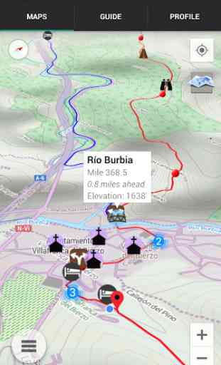
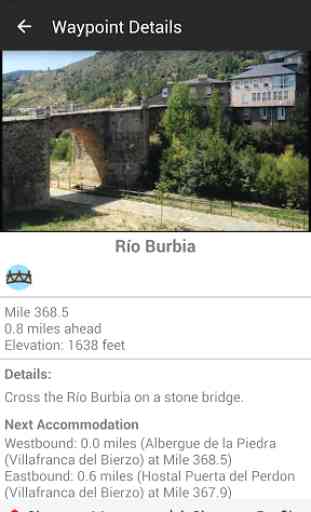
The Saint-Jean-Pied-de-Port in-app purchase maps and lists more than 1,300 important waypoints (with 1,360 photographs) from Saint-Jean-Pied-de-Port to Muxia such as accommodation, junctions, road crossings, churches, towns, and many others. Each waypoint has a detail page, providing further information.
NO PHONE OR INTERNET SERVICE IS REQUIRED to use Camino Companion after the initial setup. Camino Companion uses a combination of your smartphone's GPS, downloaded topo maps, and the Google Maps interface to accurately locate your position on the Camino. Your device's GPS pinpoints your location on the downloaded topo maps.
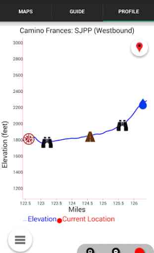
An elevation profile shows path distance vs elevation and plots your current location. Each waypoint is plotted on the profile. Each waypoints is clickable, opening to the waypoint's detail page.
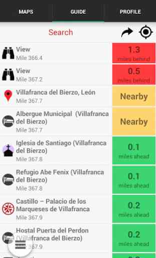
A guidebook lists every waypoint in order by distance along the trail and displays your current distance from each waypoint.
Send your current location to friends and family via text message, e-mail, facebook or twitter.
The types of waypoints include:
-->Accommodation (albergues, hostels, hotels), including kitchen, laundry, internet and meal information-->Towns-->Water taps and fountains-->Churches, cathedrals, chapels-->Junctions-->Road Crossings-->Scenic Views-->River and stream crossings-->Other points of interest (sculptures, historic waypoints, etc.)
This app is a collaboration between long-distance hiker Keith Foskett and the creators of the popular Guthook's Guides series of long distance hiking apps.
Category : Travel & Local
Reviews (27)
Superb simple and accurate mapping guide to the camino. Always reliable.
Found this app to be quite helpful on our Camino el Norte. One suggestion would be to add more information on upcoming points on the alternative route under the guide tab. Other than that gives a great overview of the journey ahead.
Detailed but not intuitive... Downloaded and created an account, but can only see SJPDP > Pamplona. No "Home" button and no list of stages. Is the app seriously only for the first etapa, or am I missing something?
Just come back from Camino. Had purchased Sarria to Santiago route. It showed Camino route which seemed accurate but disappointed as when tried to drill in on map it went fuzzy and could not see route or map.
On camino now and it is very helpful. map coming out of Logrono slightly different as arrows bring you through the park.
have to pay for stuff, most people will have google maps and you can ask the locals that doesn't cost nothing, didn't expect nothing more from the play store or it's now days paystore ripoff
This has been a great life saver and amazing for staying on the trail. Highly recommend it!!!
Very simple and informative. Most intuitive.
Very good application. How do I do If I dont want to see some waypoints on the map ?
deception, they only have one piece of the route for free
I didn't like it because you have to pay for maps
We used this daily and found it helpful.
Helped me, every step of the way.
This is my favorite Camino app of the bunch
Exactly what it says it can do. Brilliant for Camino junctions and distances.
If you are going to walk the Camino then this is the only app you will need.
Best Camino app available, and I've downloaded & examined them all. It is all I need to use for my second Camino this year and I used this last year too.
It takes time understand it's potential, maybe it needs to be more intuitive.
I first saw this app while thru hiking the AT in 2014. When I saw there was one for the Camino I jumped at the chance to try it. I used it every day and loved having the information so easily available. Much easier than pulling out a book. Navigating was a breeze. The Camino is well marked, but there are many options and this app was great. We also started in the dark most mornings so having the app made it easy compared to looking for arrows with a flashlight. We used it from SJPDP to Finisterre.
Finished the Camino Frances from SJPDP on 7/24/15. This app was most helpful in either confirming that I was on the intended path or informing me that I wasn't (and helping me to navigate back). Thank you!
I was searching for an app for the Camino Frances but none had everything I wanted. Finally I found this. I had met Guthook and used his AT app which is impressive so I knew this was just what I needed. Great!!
Downloaded the app yesterday,looks good and interesting,only trouble seems to be it needs to go from bottom to top,not the other way so you can at least follow the walk as you walk on the phone if need be,the items are well done,but I will still use the guidebook map to walk with,easy to follow the map from bottom to top,,unlike the app from tom to bottom.
The app has stopped workng. I'm at I write this in Bayonne on my way to SJPDP and I am unable to start the app. I just get the error 'Unfortunately Camino Companion as stopped'. Great. Update: after using about 280 mb of my mobile data plan to reinstall its working again. The question is for how long..
This looks like a great resource for my walk next month. Lots of navigation points and accommodation info.
I was using this app to plan out my future Camino hike. I have used Guthook's Apps on the Continental Divide Trail, Pacific Crest Trail, Florida Trail, John Muir Trail, and Tahoe Rim Trail and their Apps have NEVER let me down. I'd recommend this to anyone who is trying to plan their hike and it is an extremely useful tool while on trail as it provides all the necessary and pertinent information one would need while on trail. LOVE IT!!!
Used this app in 2017 and it was great although still had to use The Book for addition accomodation. Do you have an app for the Portuguese Camino?
Camino Companion has been a real saviour for me on my Camino Frances. Most useful has been using Camino Companion through the Cities like Logroño and Leon, particularly early in the morning when light is bad and finding your way is not always easy. Also, the App helped me to understand how far I was away from my planned destination. On hot days, knowing where the Fountains or fuentes were was really helpful too. I have no criticism pf the App at all. In fact, many pals downloaded too.