Canada Topo Maps Pro
**
* Attention: Please use Toporama or Canada Base Map layer if you need most recent topo maps ! ***
Main features for outdoor-navigation:
• Bulk-download of map tiles for OFFLINE USAGE (not for Google and Bing maps)
• Create and edit Waypoints
• GoTo-Waypoint-Navigation
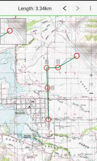
• Create and edit Routes
• Route-Navigation (Point-to-Point Navigation)
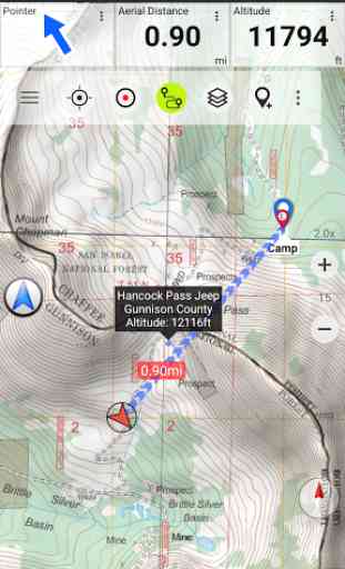
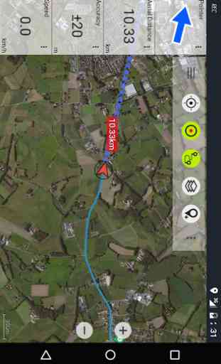
• Track Recording (with speed, elevation and accuracy profile)
• Tripmaster with fields for odometer, average speed, bearing, elevation, etc.
• GPX-Import / Export, KML-Export
• Search (placenames, POIs, streets)
• Customizable datafields in Map View and Tripmaster (e.g. Speed, Distance, Compass, ...)
• Share Waypoints, Tracks or Routes (via eMail, Facebook, ..)
• Use Coordinates in UTM, WGS84 or MGRS
• and many more ...
Available map layers:
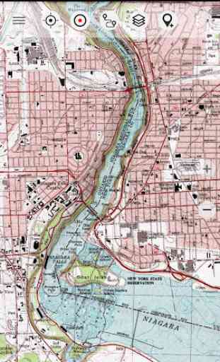
• Topomaps Canada (CanMatrix, seamless coverage at scales 1:50.000 and 1:250.000)
• Toporama Maps Canada (CanVec, NTDB, Atlas of Canada)
• Canada Basemap (CanVec, NTDB, Atlas of Canada)
• CanTopo (new Canada topos at 1:50.000, partial coverage of Can)
• Google Maps (Satellite images, Road
- and Terrain-Map)
• Bing Maps (Satellite images, Road-Map)
• Open Street Maps (OSM Mapnik and Cloudemade Cyclemap)
• Hillshading overlay layer for OSM, Google, Bing or Toporama maps
Toporama Maps Canada: These are the most recent topographic maps of Canada. Can be enhanced with hillshading overlay.
Topomaps Canada: These maps contain many small pathes and 4WD tracks that are missing in Toporama, Google, Bing and OSM maps. This layer is essential for real outdoor and offroad trips in Canada. Seamless mosaic of more than 13.000 collar clipped 1:50.000 maps.
Use this navigation app for outdoor activities like hiking, biking, camping, climbing, riding, skiing, canoeing or offroad 4WD tours.Preload FREE map data for areas without cell service.
Canadian topographic maps are enhanced with Atlogis® hillshading and placenames.Credits for topographic map data: "© Department of Natural Resources Canada. All rights reserved."
Please send comments and feature requests to [email protected]
Category : Maps & Navigation
Reviews (13)
I use this app all the time in the mountains even out of cell service. However, if you're out of cell service you have to have looked at your route before and have the corresponding map saved in the cache memory of your phone. Otherwise it will display you as a dot in white space. So I'd suggest you look at your route and use different layers too -- e.g., if you want to get an aerial view instead of just a topo view.
Its a great great great app, if you know where you wanna go and have your route planned. I was in BC and had no reception for days on end and couldnt access any of the maps. Bummer. Would be an amazing app otherwise OR if you have a route planned. As for me just going with the flow, didnt workout so well.
Very capable app. I often do trips out into the wilderness on my dual sport motorcycle. Also snowmachines and hiking. But I mainly bought the pro version to travel with my motorcycle. I plotted a route using a different app that I find is better for plotting routes. Was able to easily import it into this app . Easily made an offline map which tracked my progress perfectly over 2 days without any cell reception. Incorporate routing capabilities like in touch trails and its 5 stars. Very happy.
the map system itself is fine, everything there works, but my primary use for this app was way up north outside cell service areas. caching the maps to be able to use the GPS with no signal has been HELL. the app will not pause a download if you lose signal. when saving ESRI maps, the downloads can be upwards of 20GB. the servers are very slow, (600-900kbit/s), and it cancels the download the minute you lose coverage. 2+ days to download hoping it doesn't randomly cancel on you; and if it does, you can't actually delete the broken file it downloaded. I wish I would have given up and refunded the app while i had the chance.
So rediculously slow. I waited an hour for tapo to load but could only get a tiny square of visibility. Didn't budge the entire time. I hit the refund button before it was too late. I really hoped to have a good map system for dirt biking but if it's this slow while at home, I can't imagine the fear and frustration of trying to load a map while in the woods. Better off driving around aimlessly hoping to find my way out before running out of gas.
Purchased the pro version, liked the features, wanted to install on my tablet and was asked to buy it again! Couldn't believe, restarted all system but again, but still have to pay for every instance. Very well, got a refund for installed phone app and installed new on my tablet. Rediculous. Update: Service response in hours! Followed advise and cleaned EVERY cache including full trash sweep and restart. Now ich can install on different devices. Thanks for the support.
So far I am not impressed. The only layer that loads totally is the CanMatrix. Everything else is partial or not at all. Most disappointingly the Toporama does not load at all, even if I leave it open for an hour. I paid for the Pro version and there is something wrong with this app.
Very useful and reliable. An essential safety tool if you do a lot of backcountry hiking. If you lose visibility it could be a lifesaver. By caching the maps you need no data connection. Excellent resource.
Useful but very flakey. I love being able to cache maps. Unfortunately when browsing online the software is often so slow to update as to be useless. I am often left staring at blank areas that don't update. Even with cached data it often just shows blank tiles unless I zoom in and out repeatedly.
Great app caching offline seems to have a bug it downloads incredibly fast for the first 20 seconds then speed drops down real slow very quickly no matter how many times you try. Ended up caching smaller sections
Bought this app, worked for a while. Then stopped working and forced me to buy it again. It worked a lot better before. Takes 3 or 4 tries to cache a map properly. Also takes 45 minutes to delete a cached map??? I think in going to look for something better.
This app is great but the ability to import GPX is mising. I could't figure how to measure precise distance between two waypoint, it doesn't allow selection of waypoint while measuring. It's a must to be able to get bearing and distance while measuring distance.
This app works well all the time and never let's me down. I have used it for well over 5 years. I use it to manage all my backwoods waypoints and offline maps. Pay for the pro version and support a great product. Offline map caching is great. I'd like to be able to store my cached maps in a folder hierarchy like waypoints. This would alow me to better see what I have already cached and control memory used. I'd also like a mode where I could show a map and see all the cached maps for that area.