canua - für alle Paddler
With the canua app canua, you have access to the entire body of water knowledge of the German Canoe Federation (DKV). Water descriptions, driving rules, entry and exit points and much more at your fingertips in Germany and neighboring countries including Corsica and the Baltic States.
Please sign up for canua.info for the canua newsletter. Up-to-date information on canua is published exclusively via the canua newsletter. Have fun on the water. The canua team of TouchingCode and DKV.
Description:
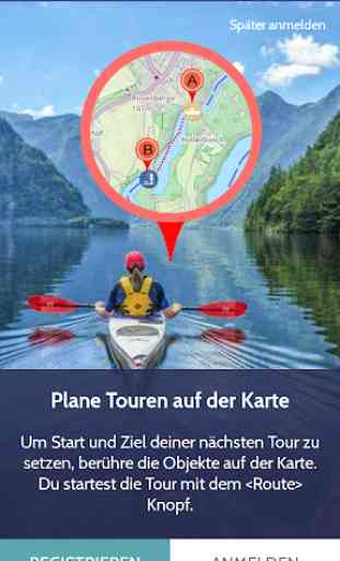
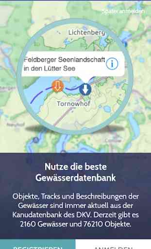
Perfect planning, recording (GPS tracker) and sharing tours on the water. Canua is based on Europe's largest water database with approximately 80,000 points and 2160 waters.
Everything in view on the water. With canua you have the characteristics and the conditions for water-walking on the waters of Germany and the neighboring countries at any time ready.
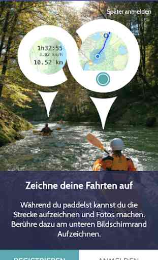
o GPS tracker: record your tour, check your pace or distance along the way and share your rides with others. The tours can also be sent to the electronic logbook of the DKV (eFB).
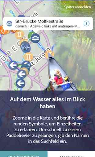
o canua provides all relevant information on every German water body. The paddling areas can be conveniently determined by search or perimeter function. Listed and vividly displayed on a zoomable map, cheap entry and exit points, weirs, danger spots, but also rest and overnight accommodations are listed.
o Information is provided on the character of the water, the gradient, difficulties, obstacles, but also on tourist attractions, campsites, boathouses and other important information for planning the journey (for example, accessibility by public transport). Ideal for those who are active outdoors. Also information on possible restrictions on driving are included.
o The app provides the content of all eight published DKV inland waterway guides.
o The map is ideal for water walkers, especially paddlers and stand-up paddlers.
The canoe database is operated and provided by the German Canoe Federation (DKV) based in Duisburg - www.kanu.de. More information also on canua.info. In doing so, canua also relies on the map data created by the OpenStreetMap contributors: Data © OpenStreetMap contributors, whom we thank for providing geodata and doing the great work. Details at http://www.openstreetmap.org/copyright.
Please sign up for canua.info for the canua newsletter. Up-to-date information on canua is published exclusively via the canua newsletter. Have fun on the water. The canua team of TouchingCode and DKV.
Description:
Perfect planning, recording (GPS tracker) and sharing tours on the water. Canua is based on Europe's largest water database with approximately 80,000 points and 2160 waters.
Everything in view on the water. With canua you have the characteristics and the conditions for water-walking on the waters of Germany and the neighboring countries at any time ready.
o GPS tracker: record your tour, check your pace or distance along the way and share your rides with others. The tours can also be sent to the electronic logbook of the DKV (eFB).
o canua provides all relevant information on every German water body. The paddling areas can be conveniently determined by search or perimeter function. Listed and vividly displayed on a zoomable map, cheap entry and exit points, weirs, danger spots, but also rest and overnight accommodations are listed.
o Information is provided on the character of the water, the gradient, difficulties, obstacles, but also on tourist attractions, campsites, boathouses and other important information for planning the journey (for example, accessibility by public transport). Ideal for those who are active outdoors. Also information on possible restrictions on driving are included.
o The app provides the content of all eight published DKV inland waterway guides.
o The map is ideal for water walkers, especially paddlers and stand-up paddlers.
The canoe database is operated and provided by the German Canoe Federation (DKV) based in Duisburg - www.kanu.de. More information also on canua.info. In doing so, canua also relies on the map data created by the OpenStreetMap contributors: Data © OpenStreetMap contributors, whom we thank for providing geodata and doing the great work. Details at http://www.openstreetmap.org/copyright.
Category : Sports
Related searches
Reviews (3)
pat.
Aug 20, 2020
Finaly I hoped for an app that does what I need. Just plan a cayaking roit. But this is complately broken app. Does not do even basic functions.
Jon. K.
Apr 6, 2021
A wealth of information, great for planning, looking forward for advanced routing features
It works but has a lot of issues. Is good as a basic map but it is missing some information like access points. It would be nice if the users could make more manual adjustments to the map or some flexible feedback which would be later checked by the admins.