CarryMap
While working with your mobile map you can easily get detailed information about all objects, find your current location, measure distance to required object or calculate its area, add new objects, describe and share them with other users, as well as search objects on your map. Mobile maps are created from Esri ArcGIS maps extracted to specific mobile format (CarryMap file, or CMF2) with an extension to ArcGIS for Desktop called CarryMap Builder. Learn more about CarryMap Builder extension at http://www.carrymap.com.
Have a look at samples of mobile maps published in the Map gallery section of the CarryMap Builder website at https://carrymap.com/en/map-gallery/
General features
- Complete autonomy
Work with your maps in any remote locations or in private networks independent of internet availability and online-services. Note that CarryMap app is free and you will not need any paid accounts or subscriptions to use it.
- Handy tools for work with mobile map
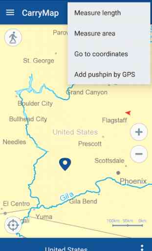
Take advantage of using your full functional mobile map
- find your current location using GPS/GLONASS option, orientate yourself to terrain, turn map layers on and off, zoom in and out, identify objects, measure distances and areas, record your tracks on the way.
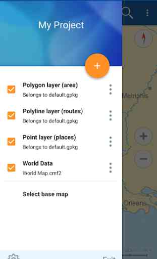
- Data collection
Collect data in the field using predefined templates and send collected data to your colleges when you get to coverage. Create new points, lines and polygons, edit existing and add new attributes to objects.
- Attaching media files to objects
Collected data can be described in more detail, just attach photos taken on-site by your mobile device or select appropriate ones from your gallery.
- Data exchange and distribution
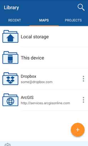
Collected data can be imported and exported to KMZ (compressed KML) format and GeoPackage (universal Open Geospatial Consortium format). Share your mobile maps with unlimited number of users by email or publish them in known cloud storages, such as Dropbox, Google Drive, One Drive, integrated to CarryMap app.
- Easy-to-use
User friendly interface clear for any GIS-savvy users requires no professional skills and experience for work with mobile maps.
- Measurements
Measure distance to objects on your map to know how far you are from your destination or calculate areas of required polygons.
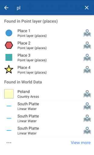
- Objects search and identification
Search objects on your map by keywords in attributes, learn information about objects from identification cards containing detailed description, attached photos, links to related external sources, etc.
Any questions or comments regarding use of CarryMap application can be addressed at [email protected].
Category : Productivity
Reviews (24)
I use this app almost daily in NM, It is very helpful when out on public land. As it shows the land status, hunting unit boundaries, etc. You can also enter and take GPS coordinates. The more you use it the better you will get.
could not download New Mexico hunting maps. uninstalled app and now I can not reinstall the app! At this point this app is useless 😠!!UPDATE!!! I have since be abke to download the app and have used the New Mexico hunting maps, only dislike I have so far is wish the map showed the private land owners names.
This app is absolutely worthless. It's unable to download any maps, and the available help documents offer no solutions to the problem.
This app is horrible. It never allows you to open the maps but always says there is not enough memory even though there is plenty of memory on my phone.
There seems to be no way of toggling the layers on and off on the app like on the desktop version. Why?
Use it with the Alabama Power co. contracting, clearing power line right of ways. Use daily multiple times a day. Never once a hiccup!
Not enough memory to loads maps . Can't install maps so uninstalling
can't create project, crashed on oppo a3s, android 8.1.0. i already installed ín my handheld. the latest is always crashed
Came in handy for are hunting and wood cutting purposes the blm maps pervaded are not detailed enough to keep u I'm the right places
Perfect for me as a forester, i never get lost with the usage of this app
"New Mexico map expired"!? The new mexico hunting map is gone. So this app has officially taken a dump
Does not import .shp file any longer on note 10.
Nice application but App is not working on above android 10
Great app for hunting and back country exploring in BLM and forests
Wonderful, but still can't read my shapefile.
It's a good one of dynamic apps. Love to use it❤️⚒️
please add direction (azimuth) in measuring tools
excelent customer support that fixed the bug in my case
I think Anime should be illegal, but was a great app.
Very good app, we hope more developing
great app. easy to use it
Need to take fencelines and water features off the base map. It's a pain turning them off everytime. Also make the roads darker like last year
Good GPS based app ..pretty accurate
In your latest update, add data icon (+) has missed from my app. Do you have other solution to add data and map from internal storage to app? Thank you very much