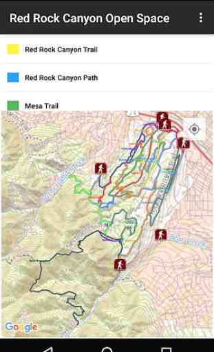
Colorado Springs Trails
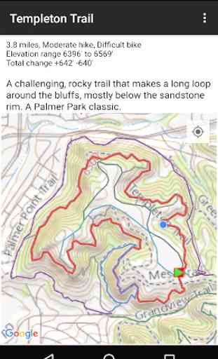
Colorado Springs, Colorado has an abundance of interesting places to hike and bike. This app catalogs over 175 trails in and around Colorado Springs, divided into 14 areas including Garden of the Gods, Palmer Park, Red Rock Canyon Open Space, North Cheyenne Canyon, Manitou Springs, and Pikes Peak. Included are accurate tracks for over 250 miles of trails, 40 trailheads, and 35 complete hikes (routes). Distance and elevation change are provided for each trail and route, along with a short description and a difficulty rating. A "Favorites" list gives you a set of interesting hikes to try, sorted into different categories (easy, hard, waterfalls, etc.)
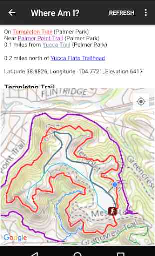
Maps are in four formats (USGS National Map Topo and three Google Map variations), with USGS Topo maps built into the app for offline use. All maps (area, trail, route) include your current position, very useful when navigating in the field in an unfamiliar area. The "Where Am I" feature will tell you which trails you are on or near, and the distance to the nearest trailhead.
Maps are in four formats (USGS National Map Topo and three Google Map variations), with USGS Topo maps built into the app for offline use. All maps (area, trail, route) include your current position, very useful when navigating in the field in an unfamiliar area. The "Where Am I" feature will tell you which trails you are on or near, and the distance to the nearest trailhead.
Category : Maps & Navigation
Related searches
Great App for anyone who is new to the area. I moved here in June and had to Google best hikes near here for months. This app would have beenn PERFECT. It has pretty much every trail around here with maps!