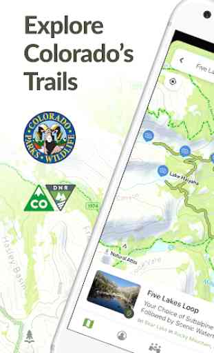
Colorado Trail Explorer
View trails by allowed uses on the map, browse featured routes, download offline maps, record trips and notes in the field, complete challenges to earn badges, and share your experiences with the community. COTREX is your gateway into Colorado’s magnificent outdoors.
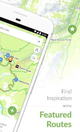
■ DISCOVER TRAILS & FEATURED ROUTES
– Browse or search to find trails and Feature Routes that match your activities or interests.
– Change activity type to dynamically filter trails on the map.
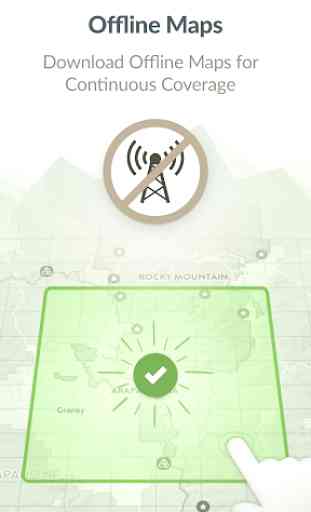
■ OFFLINE MAPS
– No cell coverage? No problem! Download maps ahead of time for a continuous experience that doesn’t depend on your network.
– COTREX offline maps are lightweight in size and easy to download.
■ RECORD TRIPS & FIELD NOTES
– Capture the details of your outdoor experiences by recording Trips.
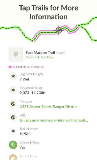
– Go beyond simple photos by taking and classifying rich Field Notes along the way. Choose from 45,000+ classifications that include trail conditions, species, rocks and minerals, historic places, points of interest, and much more.
– Seamlessly sync activity recorded on your devices with the web.
■ COMPLETE CHALLENGES TO EARN BADGES
– By recording and classifying Field Notes, you can complete Challenges and earn Badges for your profile.
■ SHARE WITH THE COMMUNITY
– Inform and inspire the entire COTREX community by sharing your Trips and Field Notes publicly or submitting Trip Reports.
– View activity feeds for all users or just the ones you follow.
– By sharing your experiences, you also help to inform trail managers about current conditions on the ground.
■ ABOUT COTREX
The Colorado Trail Explorer endeavors to map every trail in the state of Colorado in support of the Colorado the Beautiful Initiative. COTREX connects people, trails, and technology by coordinating the efforts of federal, state, county, and local agencies to create a comprehensive repository of recreational trails for public use.
This project is led by Colorado Parks and Wildlife (CPW) and Department of Natural Resources, but is only made possible through partnerships with organizations at every level statewide. COTREX represents a seamless network of trails managed by over 230 land managers.
■ DISCLAIMERS
[Battery Life] We do everything we can to make the app low power when recording, but GPS is notorious for reducing battery life
Terms: https://trails.colorado.gov/terms
Privacy Policy: https://trails.colorado.gov/privacy
Category : Maps & Navigation
Reviews (20)
Excellent app! Two suggestions: - It would be useful if the app would continue to run in the background. If you turn the screen off and on the logo comes back in again and the app relaunches, this is very annoying when hiking. - It would be great if you could be able to rotate the map (like google maps) so that it faces the direction you are walking.
Excellent trail map for ATV riding. We used it this past weekend for the first time and barely scratched the surface of it's functions. It was awesome to have the offline capabilities and with it's constant update as to our position on the trails, it definitely kept us from getting lost in the high country. We'll be using this app now to find new places to ride and explore as much of Colorado as can. Thanks to the developers for a great app!
Overall, I love this app! I love being able to download map sections for offline use without having to pay. I use it for every hike I do in Colorado. If it doesn't already have the option, (because I haven't tried yet) It would be nice to have every state have some kind of app similar to this and be compatible so hiking stats from out of state hikes can be saved in the same app. Otherwise, I will have to continue using All Trails everywhere else.
Wow. This is a free app? Incredible. It's very good for a paid app. It has a limited map set, given. But MVUM, sufficient topo with USFS road numbers, and satellite is all that's needed for overlanding/4wd in particular. Offline downloading is EXCELLENT. Very fast with a great interface. Beats the living pants off Gaia GPS in this regard, which has a terrible download/offline setup that is insanely slow most of the time. To top it off, map scrolling and display speed are crazy fast. A+
Wonderful app with amazing features!.. and it's free! Handy measuring tool snaps to available trails. Downloadable maps for exploring in the mountains when you have no internet connection. I find this app more useful than AllTrails for hiking in Colorado. I just wonder why so few people have reviewed this great product. Perhaps they're all out hiking.
It's a good app for finding your way out on the trails but the information is extremely incomplete and fragmented. Some road/trail segments are unlabeled so route finding can be inaccurate and it's easy to find yourself on private land. But overall, the info is decent and relatively easy to piece together.
searching still needs a little work. At first searching would only return 2-3 trails based on the difficulty level. Now when searching only for ATV trails it returns 5k trails but includes all trails, including hiking only trails. search filtering needs a bit of attention. This will be a great app once the bugs are worked out!
This app is AMAZING the little I've played with it. I'd like to be able to spin the map, and I'd like to see a "vertical feet" or elevation profile rather that a X' to X' elevation listing. however it being accurate and the distance tool is worthy of 5 stars. SO COOL!!
Good navigation app especially given that it's free with no ads. Using for Nordic ski trips this season. I have noticed accumulated trip mileage seems to be off by about 10%. Accumulated elevation gain is off by about 40%.
Looks like it's got potential, but no tutorial for all it's theoretical capabilities makes it nearly useless. I'll stick with GAIA GPS. At least you can find many tutorials for gaiagps which show the full potential for the program.
The only app I could count on in the backcountry of Rocky Mountain National Park!
I would have been lost in arapaho national forest if not for this app. I was trying to decide whether to push through or turn around on a trail, and none of my other apps were working. I downloaded this one literally that morning, and it was the only one that worked. It let me know that If I had kept going, it would have been a 15 mile trip to get back to the trailhead. I definitely turned around. Can't recommend this enough!
Orientation- Landscape mode only?? Was pretty excited to find this app until I opened it and discovered it only works in landscape (sideways) mode. Have never seen this before.. I have a tablet that fits perfectly in my off road motorcycle tank bag VERTICALLY.. I don't understand why anyone would build an app that only works in this way... It makes the app unusable for me and my riding buddies.
The main reason I use COTREX is the ability to download maps and view them offline. But since this app has no external SD card support, it's a pain to delete and re-download particular maps every time you hike a different area.
Fantastic design, great features! This app has a lot of the features in AllTrails premium version, but it's all free! Trails are more accurate and authoritative as well because the info is coming from land management agencies rather than crowdsourced.
Finally the government did something right. It's free, has lots of data, allows offline use, and is easy to use. I do wish the satellite images were higher resolution and that it worked outside of Colorado. Looking at you, Utah and Idaho.
Over all a good app. I enjoy being able to set my own custom routes. Some trails are definitely not mapped correctly. Would be really nice to filter trails by surface type.
Exactly what I need. Allows custom routes with a premapped Colorado bike trail system map. All known bike trails are there. Gives section and route details by clicking anywhere on the map. Does not require additional purchases. Its a Colorado bikes dream come true.
Is give this app six stars if I could! Fantastic for planning hikes with all kinds of goals- scenic, waterfalls, wildlife, etc. Can also filter on distance and altitude change, difficulty, etc. Fantastic app!!
Does a good job of selected trail closure/opening notification. Map is descent enough for trail hiking. Overall, I'm a user and satisfied with it. Edit: Be advised that the app is a resource hog, 43%/hr of my 3300 mAH of my smartphone battery. Only will use at home, not in the hills.