Coordinate Tools Free
Visit us on Facebook: http://www.facebook.com/pages/NebSolutions/193862820690436Follow us on Twitter: http://twitter.com/#!/NebSolutions
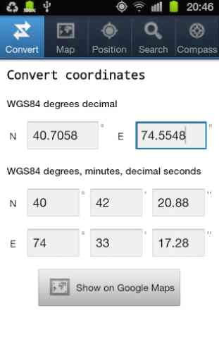
Note: You can use negative values for coordinates on the western or southern hemisphere:Examples:
For the north-western hemisphere:N: 40.71, E: -74.0 (New York City)
For south-western hemisphere:N: -34.6, E: -58.4 (Buenos Aires)
For the south-eastern hemisphere:N: -33.87, E: 151.2 (Sydney)
For the north-eastern hemisphere:N: 52.52, E: 13.4 (Berlin)
Keywords: WGS84, coordinate converter, compass, coordinates, find current position, send current position
Category : Tools
Reviews (24)
Using 1 minute of arc on the earth = 6000 ft = 1 nautical mile is best accuracy for plotting a position or scaling off an object on a map for sailing walking flying and driving. This makes 1 second of arc 100ft and does not interfere with use of statute miles or kilometers for engineering and construction. Degrees Minutes (or Miles nautical) and Seconds DMS. John.
Lowest rating possible because it assumes northern hemisphere, and I cannot easily find a setting to change that.
Not very good. Keep putting me in the wrong place when i convert. Has a good compass.
doesn't seem to allow me to change coordinates to South or even detect that.
..if the developer allowed it to recognise decimal minutes as well as seconds. I need that so I'll keep on looking. The compass is cool though.
Though was draining my battery off so I had to uninstall it
I attempted to use the send coordinates feature but it didn't work with any of the available targets. Great possibilities but sub beta quality even for a free version.
Help me find place using coordinate! Wonderful! Im going to recomend this app to my friend
Works fine on my non-rooted T-mobile MyTouch G4. Free, simple, e!legant! It probably does more, but I mainly needed local coordinates for astronomy.
Simple but extremely helpful for using in various geolocation apps. Beautiful!
Only add option to save multi position and if can add the rout
Nice app but hangs on my galaxy y..
Major error in latitude conversion from deg.decimal to d-m-s format
Gives absolutely wrong current coordinates.
One must try at least once
It olnly supplys coordinates for NE I live in NW in wyoming uninstalling
I really like this app.
This is very helpfull to me
I initially like it Revision while in use is required
I like this app...
Use it regularly
How can i change este to west?
Calculation doesn't work for southern hemisphere. Plots completely wrong position on map
Useless. No option to exit app or copy coordinates. Send position only creates a blank message.