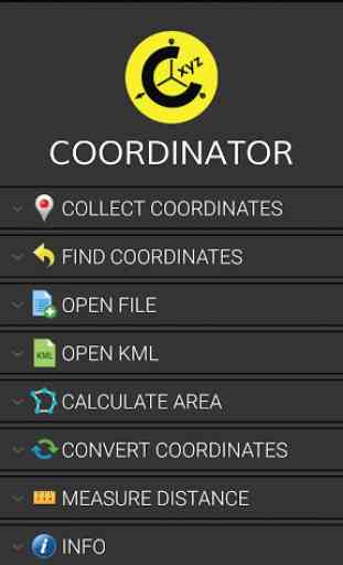
Coordinator-Collect Coordinate
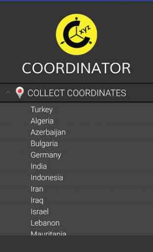
The coordinate systems of the countries, which the app is most downloaded, are added to the app. Current list of the countries and their coordinate systems defined in this app:
World
- GPS(WGS 84)World
- WGS 84
- 6 ̊ UTMAlgeria
- "Nord Sahara 1959 / UTM 6 ̊ "Azerbaijan
- "Pulkovo 1942 / Gauss-Kruger 3 ̊ " and "Pulkovo 1942 / CS63"Bulgaria
- "Pulkovo 1942(58) GK 6 ̊ "Germany
- "DHDN/3 ̊ GK" and "ETRS89 UTM 6 ̊"India
- "Kalianpur 1975 / India" and "Kalianpur 1975 / UTM 6 ̊"Indonesia
- "Indonesia 1974 UTM 6 ̊" and "DGN 1995 Indonesia TM3 ̊"Iran
- "ED50(ED77) / UTM 6 ̊"Iraq
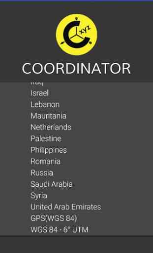
- "Nahrwan 1967 / UTM 6 ̊" and "ED50 / Iraq National Grid" and "Karbala 1979 / UTM 6 ̊"Israel
- "Palestine 1923/Palest. Grid" and "Palestine 1923/Israeli CS Grid" and "Israel 1993/Israeli TM Grid"Lebanon
- "Deir ez Zor / Levant Ster." and "Deir ez Zor / Syria Lambert"Mauritania
- "Mauritania 1999 / UTM 6 ̊"Netherlands
- "Amersfoort / RD New" and "Amersfoort / RD Old"Palestine
- "Palestine 1923/Palest. Grid" and "Palestine 1923/Israeli CS Grid" and "Israel 1993/Israeli TM Grid"Philippines
- "Luzon 1911 / Philippines" and "PRS92 / Philippines"Romania
- "Dealul Piscului 1930 / Stereo 33" and "Pulkovo 1942(58) / Stereo 70"Russia
- "Pulkovo 1942 / Gauss-Kruger 3 ̊"Saudi Arabia
- "Ain el Abd / UTM 6 ̊" and "Ain el Abd / Aramco Lambert"Syria
- "Deir ez Zor / Levant Ster." and "Deir ez Zor / Syria Lambert"Turkey
- "ITRF 96
- 3 ̊" and "ED 50
- 3 ̊" and "ITRF 96
- 6 ̊" and "ED 50
- 6 ̊"United Arab Emirates
- "Nahrwan 1967 / UTM
Category : Tools
Reviews (29)
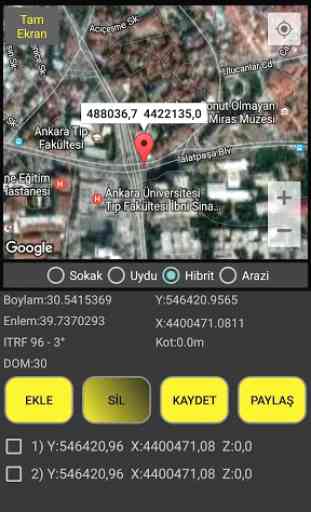
it gives x and y coordinates and altitude(z coordinate) according to different systems and countries. For example if you have been living in Turkey, you need to choose collect coordinates then Turkey option then the system option you need (ed50 6 utm was wanted from me because i am a mine engineer), and then you can see decimal degrees and x, y coordinates easily. z is altitude from the sea level and although z symbol isn't written, you can see it as altitude.
I was excited to see that US State Plane coordinates are supported, but there does not seem to be a setting to display the results in US feet, the native system for US State Plane coordinates. Having to manually convert meters to feet makes this feature too cumbersome.
I have loved this app. It's blended with several functions, easy to use However I hate the adds below it. Improve for the future.
The last version is very bad, I had to downgrade to previous version and disabled the auto update.
Hard work pays. It's a good product. Please promote African geological and geodetic geometry always.
Thisis a simple collector, but goodrunning in gadget, simple conventer but powerful in indonesia. GoodJob.
Very nice app, very usefull for field aplications! Hey guys, is there some forecast to add UTM projection zones for Brazil in WGS84? Tks!
Well the app refused to work from my Android Galaxy Tab E! I uninstalled & re-installed but all in vain! What could be the problem?
It's an easy to use app. Thanks very handy for simple field tasks
Can you please add search feature while collect coordinate? Much appreciated Edit : Thanks for the reply, much appreciate it
Good app. But only x and y are recorded, the z field turns to zero
Very good. It will be usefull if it can be introduced 4 points, not one.
Tool "Find Coordinates" doesn't work, useless app in that case
I can't signing in with my google account, can you fix this problem? Thanks
fantastic and make things easier than before
I love it use Good App for collecting Data after new updat its become more cool
Love it! But how do I change elevation units from meters to feet? And what is CM?
I just enjoy this app, it's amazing. Love you the developer team
this app can not record altitude
Very useful and accurate
Data wont save on Android 11 ver 3.0
it doesn't open with maps
Downloading is not up to 72%.what is the problem?
Good application ... easy to use ...
This app should also have running length
The compass does'nt work
its great add more usefull by mil activities
Quick help and problem solved
Thank you. How about fast selecting any marker name from a text list box with all markers.