Custom Maps
Custom Maps can use photos of paper maps or brochures, and pictures of maps posted at trailheads or at the entrances to amusement parks. It can also use .jpeg or .png images downloaded from the internet and screenshots of PDF maps.
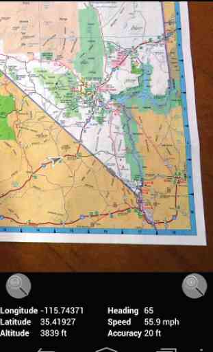
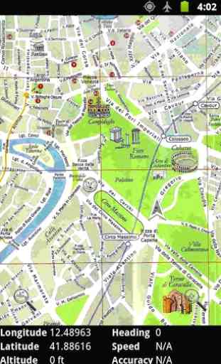
All you have to do is choose two (or more) matching points that are common to both the map image and Google Maps, and Custom Maps can then show your GPS location on the map. Data connection is required at the time the map is calibrated (created).
As the map images are stored on the phone, Custom Maps works offline without data signal. This is useful if you go hiking in national or state parks, and it can help you avoid international roaming charges abroad.
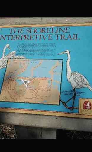
Custom Maps can use almost any map image, including photos, as GPS maps so it can be a helpful map application when visiting zoos and amusement parks which typically post large maps of the park layout at the entrance of the park. Just take a photo of the posted map, line it up with Google Maps, and you can see your location on the map photo wherever you are in the park.
Custom Maps can show the distance from your current location to a point on the map, so it can give you an idea how far different points are. This is especially useful for golfers who could create their own GPS maps for golf courses they play.
Custom Maps uses simple image files for maps so you can add your own markup on the maps in a graphics tool (not included in Custom Maps) or draw entirely your own maps. Created maps can be shared using email from the app itself, or by hosting the map on a web server and posting QR codes for others to scan to trigger downloading of those maps.
Custom Maps supports displaying placemarks on the map (starting in version 1.3.0). Placemark editing is not supported in Custom Maps itself (will be supported in a future version), but placemarks can be added in Google Earth. To add placemarks to a map, copy the kmz map file from phone to desktop computer, and open it with Google Earth. Create a folder in Google Earth containing the map overlay and add placemarks to the same folder. Then export the folder from Google Earth as kmz file, and copy back to phone.
NOTE: Custom Maps app does not come with any maps included. The help menu for the map listing contains a link to www.custommapsapp.com website where you can download some sample maps to try. However, the best way to try Custom Maps is to take a photo of a paper map (or of an online map displayed on your computer screen) or download a map image from the web to your device, and then use Custom Maps to create a GPS enabled map from it.
NOTE: On some devices, newly created maps don't show up in map list until the user returns back to map list from normal map display or after exiting and restarting the app. This seems to be an issue only with very few Android versions on specific devices, in most versions newly created maps show up immediately after they are created.
NOTE: You can sign up to be a beta tester for Custom Maps at https://play.google.com/apps/testing/com.custommapsapp.android. Same page allows you also to leave beta testing. If you try out the beta version of the app, please send an email to [email protected] telling me what device and OS version you tried it on, and whether the beta version worked for you.
You can find more information about Custom Maps at the application web site http://www.custommapsapp.com/.
Custom Maps is an open source project. Its source code can be found at https://github.com/markoteittinen/custom-maps
Category : Travel & Local
Reviews (22)
Fantastic for Georeferencing images using Google Maps satellite view and then saves it as a .kmz file, which is super handy. One shortcut that took me a while to discover is you don't really need to spend time rotating and zooming the map as long as you match up the point on the map with the point on the satellite. But the rotating and zooming is very handy for confirming if you are unsure.
I have used this app for years and love it. But, have now ran into an issue. I get an error of "The selected map could not be load as it was to large". I get this when trying to create a new map from a jpg. The jpg is 3615 x 4600, ie 16,629,000 pixels. The limit is 24 megapixels. Ideas?
Very useful app as a taxi driver. I made whole London and if I have to be in a certain area just turn it on. The only problem the app doesn't support large files so it reduces the quality of the file I use. Hope it will be fixed
Does what it does great! This is such a useful tool though would it be possible to allow import of pre-georeferenced images (geotiffs)? Then the app instantaneously allows people to use other custom maps too
How can anyone rate this less than a 5? It does exactly what it says it can do. I've used this to geo-tag over fifteen maps that I use all the time. I've even downloaded depth charts for our local lakes and geo-tagged them so I know where the drop-offs are. It's incredible that this is free with no ads. Thank you Marko for taking the time to develop this.
Excellent app. After updating from the previous version, you can get all your previous maps back by opening them individually from the Custom Maps folder. Once in the app, you can save all your maps using 'Export all maps'
Fantastic app. I needed something like this for work, and luckily somebody had thought of creating it. I don't consider myself a map fanatic, but I'm even using it in my free time to play around with historical maps of my local area!
Brilliant app. I drew a map of my home town as it was in 1830 from old surveyor maps, exported it as a 4800 x 4800 px PNG, imported it into the app, made 5 tie points, and it worked perfectly and accurately. Great for navigating historical maps.
Very cool app. Would be nice to be able to enter coords for tie points without data service. Integration with OSMAnd would be fantastic, but just being able to enter lat / lon directly world be good.
App does exactly what it claims to do. Simple and Easy. No interference from ads. More options to save and export would be good.
Fantastic job, I have a question/suggestion though. Is it possible to create/select a mode where the user always points forwards on the screen and the map rotates instead?
Warning, many rating bots. This is not what it seems to be. When you load in it asks you to load a image of a map. I didn't get much further than that. Way too confusing. It goes to your folders on your phone. It doesn't even go straight to you image folder. You have to find it.
It did not work at all and I did not know what to do with my images. Edit: This review was written on a Chromebook. I didn't try this app on a Chromebook. The issues listed above were from when I was using Custom Maps on my phone.
Fantastic app! Thank you for developing such a useful tool. Much easier than creating a similar map on Google Earth.
Nothing else like it. I use this every time I go on a backpacking trip. It's so nice to have a blue dot on a park map. Love the new features and UI.
Working great, calibration is simple, good idea, good implementation. Using it for years now.
I have been using this app for years. Now it appears that the new version cannot use the 100s of maps I already have.
We use it for orienteering maps in Turkey after uploading .kmz file into the app's folder. Thank you for this very useful work.
Wow simply perfect! Was able to make GPS versions of my grandfather's nautical charts in no time at all!
This game is good but sometimes when I pick a photo I see preview then glitches happen and the game stopps but this game is still awesome more than that!
I really wanted to use this app but for some reason it's giving me 404 error code when I click on any map please help!!!!
I've been doing some offroad/woods driving using maps from whatever park I visit. The problem is some trails are easy to miss just looking at a static map. Google maps gps mapping is great but it doesnt match the park map. Google maps is either missing valid park trails or has ones which are not valid trails. This looks like exactly what I need to take a park map and use the gps position on THAT map. I havent tried it anywhere except at home, but this seems to do exactly what I need. Thanks!