DroidEFB - Fly with Android
- matches many features found in ForeFlight, but for Android! This pilot app provides GPS navigation and flight planning support. Full featured and reliable, DroidEFB is a must have aviation app for general aviation and professional pilots:
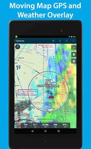
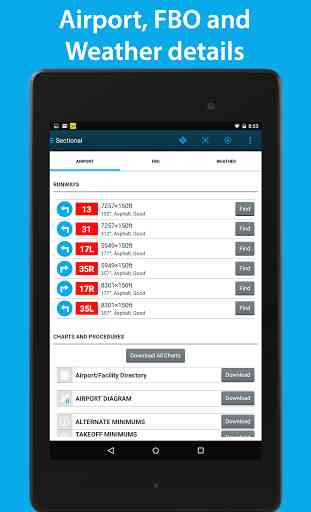
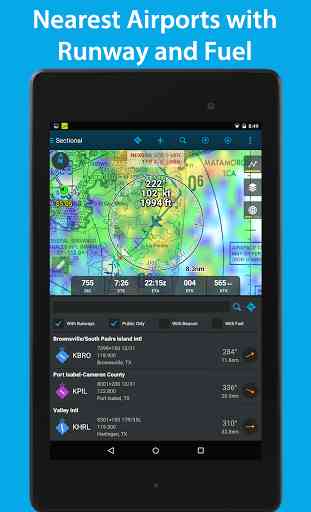
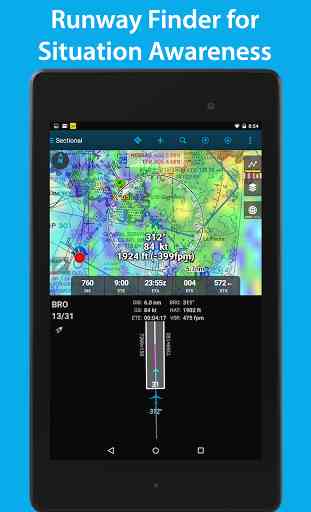
*En-route GPS navigation via moving map*NOAA aviation weather and NEXRAD radar*Geo-referenced approach plates and taxi diagrams*ADS-B compatibility*Make notes on charts and approach plates*Weight and balance*Fuel price and FBO information*Flight plan filing*Search for points of interest
SUBSCRIPTION OPTIONS:30 day free trial$6.99 per month for VFR$74.99 per year for VFR$149.99 per year for IFR Geo-referenced approach plates
Highly capable and responsive, this Electronic Flight Bag (EFB) reduces cockpit workload and provides relevant information when you need it. DroidEFB™ matches many features found in the ForeFlight® app, which only runs on Apple’s more expensive mobile devices.
DroidEFB overlays current position and flight plan onto an FAA Sectional, TAC, Low Altitude or High Altitude chart. On the ground, current weather is displayed for long range planning; helping pilots visualize the impact current conditions will have on their flight.
Input and easily amend airports, waypoints, victor/jet airways, GPS coordinates and DME. Advanced navigation log with time/distance/bearing info takes into account current winds aloft using proprietary algorithms.
Once airborne, routes flown can be stored as GPS breadcrumbs, uploaded and viewed in Google Earth. https://droidefb.com/tutorials/
All charts and plates are viewable via our servers with an Internet connection and are downloadable for offline use. RouteMinder™ automatically checks the planned route for Charts needing downloaded.
DroidEFB can be used to receive and file official briefings through Lockheed Martin Flight Services AFSS! Register at www.1800wxbrief.com/Website/ and enable Avilution/DroidEFB in the list of service providers (Flight Planning & Briefing > Service Provider) to receive notifications.
DroidEFB Features:-Point of Interest (POI) Search
- find and save airports, street addresses, business names, coordinates-Approach plates and airport diagrams (Geo-referenced with Premium subscription)-Create, save and sync user waypoints and Flight Plans-NEXRAD and ADS-B traffic (TIS-B) w/supported devices-Write or draw on charts and terminal procedures-Sophisticated weight and balance-FBO Fuel Price (100LL; Jet A)-VSR (vertical speed required)-Special Use Airspace (SUA)-Store data on External SD-A/FD (chart supplement)-Pinch zoom and measure-Redundant data servers-Real-time GPS tracking-Grand Canyon Charts-Helicopter Charts-Track prediction-Auto Logbook-SAR patterns-Track Log
Weather Overlay:-NEXRAD (Internet, MobileLink, ADS-B)-SIGMET / AIRMET (Internet, MobileLink)-METAR (Internet, MobileLink, ADS-B)-PIREP (Internet, MobileLink, ADS-B)-TAF (Internet, MobileLink, ADS-B)-Surface and winds aloft (Internet)-Current Icing Potential (Internet)-Satellite imagery (MobileLink)-Lightning strikes (MobileLink)-Freezing levels (MobileLink)-NOTAMs (Internet, ADS-B)-Area forecast (Internet)-TFRs (Internet)
Third party devices and programs integration:-Baron MobileLink-iLevil with AHRS-Microsoft FSX-Dual XGPS-ZAON XRX-Pathfinder-SkyRadar-X-Plane-Stratux
FAA Approved
- Class 1 Electronic Flight Bag (EFB)
- Reference AC91-78 and AIM Chapter 1
US Only, VFR and IFR
For pilots using phones and tablets running Android 4.0 or higher.
One subscription or free trial may be used on multiple devices such as a phone and tablet. Subscriptions authenticated using the Google account on your Android device. Free trial features a Standard subscription with no restrictions.
Rooted devices not "officially" supported
We cannot respond to feedback or app issues left in Google Play reviews. For support, visit https://www.droidefb.com
Category : Maps & Navigation
Reviews (27)
Requires a Google account and way too many permissions for that Google account... You can try to justify it all you'd like but other people don't need it so why do you? Hell, even foreflight doesn't need that much...
Edit: Thanks for the quick reply! I had confused "Max Zero Fuel weight" with "Hull weight" as I haven't ever heard it called that before. Leaving one start off for a bit of clumsiness in the UI, but maybe I'll get used to it as I go. Otherwise it's looking like it has some potential! Original post: First thing I tried was the weight and balance screen and i was unable to get it to work. just keeps saying my gross weight is -1.
I thought the software was just ok and therefore ended up getting another EFIS program. Didn't realize that I was on a subscription for the software and it renewed automatically. Since I wasn't using it, I requested a refund and quickly found that their customer service is horrible. Requested a refund multiple times and did't hear a word back from them.
This is a robust and reliable solution for Android, and runs well on my Samsung tablet as a dedicated EFB. I recommend it to students as an alternative to IPADs. I'm a professional pilot and use this for both personal and commercial flying when not with a company IPAD. Its straightforward and intuitive to operate and permits primary navigation without working very hard at it, a very important feature when you have to operate multiple aircraft with different FMSs and EFBs. I don't really care about 'value-added' features like weight and balance, aircraft profiles, GPS geo-referencing, etc. on an EFB, I just want it to have current charts and always work the way I do, which it does. I would like to see international chart options or at least Canadian charts in addition to US charts.
I downloaded this to try as an alternative to Foreflight (because I have an Android phone). It looked promising until I noticed that it installed 4 different apps, but most of all, about 100(!) beeps and vibrations on my phone while downloading databases and during the first simple flight planning. Drove me nuts and I had to uninstall. Just not workable during a trail to receive about 100 beeps, messages, etc. Too bad, very unfortunate. It looked promising.
UPDATE 2/29/20: Returning to aviation after a 12 year hiatus, I found that this has all the stuff I used to need a flight bag full of charts and gear for. Although operation is fairly intuitive, a better tutorial laying out the finer points would have improved my learning curve. Very slow (∼3 wks) responding to my claim for an advertised discount on a subscription, and my free trial expired, but ultimately they refunded the difference. Other reviewers report better response times from Support.
The user interface is perhaps the best of all the Android aviation apps. That said, this app is falling behind the competition in terms of features. I was also very frustrated that internet access to NEXRAD weather was lost for a month when the national weather service changed the format of info. Although the change was initiated by the NWS, other aviation apps were ready and had no lots of functionality. I'm currently running 2 Android flying apps and may drop Driod EFB when my annual sub ends.
Runs very well on my Samsung S6 Lite. I use it for charts, to file flight plans, and moving map. It's easy on battery (2 hr flight with display on and still plenty of battery). Weight and balance was a little difficult the first time I entered numbers for the plane I usually fly, but got it figured out. Only thing missing is performance calculations like takeoff distance for density altitude. Weather decoding would be nice, too, but there are plenty of other apps for that.
I have used it for 50 hours and I prefer it over the GPS in the plane. Load my plans at home and save them. Only gripe is when using my stratux adsb- in there is no way to enlarge the aircraft and data associated with them. A way to select font size or a momentary enlargement after a touch would really improve things.
I'm using the basic program (not the premium with the wx.) I'm an android only person, and wanted something that was cheaper then Garmin. I used Garmin during it's free trial period and once It expired I switched to this. This has everything I need for my general aviation needs as I get my Fixed Wing add on ratings. (I'm a prior Heli guy). I used it right off my Samsung Galaxy Note 4 with the internal GPS. This has worked perfect for my needs and the subscription price is much better then the alternatives. Droid EFB is a great program, and the developer has responded to my questions too. Note* I also tried wing X Pro for android. That was a BIG Disappointment, it works great for the Apple products, but they removed most of the features you need for the android. Do not use Wing X pro for android!
Fantastic APP and best I've used for Android. I have no complaints at all. I use an older Qstarz BT GPS and it hooks up immediately with the APP and accurate. I'm not an iPad fan and was really hoping to find something like this for my Samsung A8. Keep developing please! I'll be subscribing at the end of trial without question.
I've been using Droidefb and its predecessors by the same developers for probably 6 years now. It's mature, refined and intuitive to use. Support is outstanding (even on a Sunday). Updates have valuable content changes and pertinent functionality additions. Speaking with these guys on multiple occasion face-to-face at Oshkosh to get impromptu training and explanations seems to be genuinely valuable to them. These guys are the real deal, sincere and truly interested in feedback to make this app the best in the business for which they've achieved and surpassed. The app is super stable, consistent and quick to boot, operate and only need to update the charts by state. None of the guessing which IFR enroute chart number or approach plate book is the right one to load. Keep up the great work!
update to my initial review.... was finally contacted by customer support and the issue resolved in a VERY fast manner. Paul was quick in finding the issue and refunding me. I will be contacting them to renew my subscription now that the error has been resolved. the app itself is extremely helpful in flight and in flight planning. The other efb's offered on android don't quite compare in ease of use and clarity.
My instructor recommended it while I was completing my IPC. I'm a long time round dial and paper charts pilot. I still carry paper charts with me, but this is very cool. I like the geolocation feature on the approach charts, the VFR sectional is cool too, and I like entering my IFR clearance in the flight pad. Haven't tried out the weight and balance yet but I'm about to.
I have subscribed to this app for several years and it is probably the best Android electronic flight bag I have found. It is a little quirky but once you get used to it, it seems to works well. There always seems to be a workaround to get something done. Support usually gets back in touch with you in a reasonable amount of time.
I just used this app last weekend and it worked great. Easy to use. I used a Samsung Tab E and a Stratus ADSB in unit. It was no problem pairing them together. Got the basic app for free due to being an active CFI. Excellent combo and since all my hardware is non apple the easiest way to go. I would recommend this app for aircraft navigation.
Overall I like this app. I've been using it for 4 years. One feature I wish they would add is a base map. Looking at ADS-B traffic on sectionals and low altitude charts is a little annoying.
I have been a DroidEFB user for 2 years. I find DroidEFB easy to use. You can easily use it for basic VFR navigation, but it offers much more sophistication. Updates to maps and the database are painless. I highly recommend!
Top notch Android EFB. Easy to use and update databases. Intuitive and simple user interaction, with split screen capability. Comes with separate handy weather and W&B apps. Compatible with non Garmin avionics (displays traffic and WX from my NGT-9000 nicely). Georeferenced approach charts are great for IFR.
Not an easy app to use. Weight and balance is extremely difficult and there is no manual or user instructions. The so called manual mostly just shows you how to navigate the app and not how to use it as an EFB.
Ad is misleading. It promises a 30 day free trial in the US. Free 30 day trial did not work for me. I ended up signing up for the monthly subscription for the trial at the $6.99 price. I cancelled subscription after trying program for about 30 minutes. It appears that the advertised trial for 30 days is a way to trick someone into signing up for a non refundable cancelled subscription. I ended up paying $6.99 for the trial that was suppose to be free for 30 days.
It's not foreflight, but definitely the best EFB for Android. Love the breadcrumbs feature but doesn't always save them. Can always be improved and Geo-reference on approach plates would be nice.
Excellent customer service, very quick, helpful and friendly. The app was very useful and easy to use for the price. Would highly recommend to any pilot with android devices
I am a civilian military airspace manager (Air Force), and use DroidEFB for conducting our airspace surveys. I appreciate the detail that they have included with what I feel is the best Android EFB app out there. The fact that they have considered my military career with a complimentary copy is a plus. I have purchased it before and would again if that option were not available to me. I am also a Civil Air Patrol member and feel it provides some good support for what we do. I really like the software and use it often. I can highly recommend DroidEFB to anyone who is not tied to an "I" anything and likes to fly with a great EFB program. Foreflight, which I have used is good, but I like DroidEFB even better. 5 stars! Byron Schmidt
Really wish it worked with more ADS-B units. It is the only reason I will be switching to foreflight. Otherwise, I have been happy with it for the last 2 years
Started using this app on my sampsung tablet and Android phone. Works great for what I do. I use it for my gps during flight, it has all the info I need except for up to date weather because I don't have service.
This app is great for Samsung users in the aviation industry. I can easily plan cross-country flights, look at weather and TFR information, view any airport information as well as different approach charts. I like the way I can choose my departure and arrival routes from the flight plan tab and have those points automatically plotted on the map. I would like to see that same concept with the approach plates as well as a page for Chart Supplement and TTP legends with preferred IFR routes.