DRONAR - FlyWatching for Drone
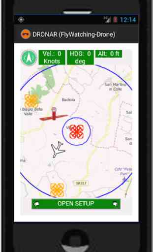
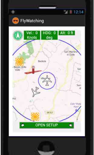
DRONAR is the FlyWatching version for Drone.DRONAR, when connected to a drone, depicts on a map, at the same time, both the own drone's position and the position of others drones, aircrafts and airfields. It is a similar to a radar. DRONAR offers the possibility to transform the own mobile device or PC in a portable aircraft/airfield radar.
This version is only for DJI's products. Please, visit www.flywatching.com for more details.
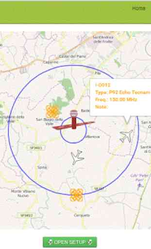
Each user, in real time, can take under control own flight parameters, such as ground speed, heading and, altitude. In addition, the users can visualize information about other drones, aircrafts and airfields, such as aircraft type, ID-Code, radio frequency used, runway conditions and, more.
----------------
The FlyWatching project provides tools for tracking the live air traffic that takes place close to a pilot (of drones or aircrafts) or to an airport.
Its primary goal, but not limited to, is to provide an aid to managers of airfields and pilots for controlling the air traffic where the classic aeronautical control systems (transponder, ADS-B, etc.) are not present or not applicable, such as in ultralight aviation, in free fly, in drones flight and, in not-controlled airfields.
In addition, it can be used as an air navigator.
FlyWatching includes three use versions:
• For aircrafts: An app is installed on a mobile smart device (smartphone, tablet, etc.) which needs to be brought on board. The smart device must be equipped with GPS system embedded and Internet connection. At prefixed time interval the app send GPS position to FlyWatching server and get the GPS data of others aircrafts and airfields around it.
• For Tower PC: A Web service is provided at the web address: www.flywatching.com. Such a service allows to control the air traffic of a region close to an user-specified location. The service does not require any GPS embedded system because the location must be provided by tower-user or it is determined automatically by the browser.
• For Drone: Generally, the Drones are controlled by radio controller. Nevertheless, most of them are equipped with a Wi-Fi or Bluetooth communication devices through which other devices can get connecting. Most Drones allow to be controlled through such connections. Some radio controller of several drone models offer an USB connection which can be used to get Drone’s control by an App running on a smart device connected via USB to radio controller. So, by running FlyWatching-Drone version on a smart device with such technology embedded, it is possible to get flight data and, then retrieve its GPS position. Then, by using the Internet connection, these GPS data are sent to FlyWatching Server.
This version is only for DJI's products. Please, visit www.flywatching.com for more details.
Each user, in real time, can take under control own flight parameters, such as ground speed, heading and, altitude. In addition, the users can visualize information about other drones, aircrafts and airfields, such as aircraft type, ID-Code, radio frequency used, runway conditions and, more.
----------------
The FlyWatching project provides tools for tracking the live air traffic that takes place close to a pilot (of drones or aircrafts) or to an airport.
Its primary goal, but not limited to, is to provide an aid to managers of airfields and pilots for controlling the air traffic where the classic aeronautical control systems (transponder, ADS-B, etc.) are not present or not applicable, such as in ultralight aviation, in free fly, in drones flight and, in not-controlled airfields.
In addition, it can be used as an air navigator.
FlyWatching includes three use versions:
• For aircrafts: An app is installed on a mobile smart device (smartphone, tablet, etc.) which needs to be brought on board. The smart device must be equipped with GPS system embedded and Internet connection. At prefixed time interval the app send GPS position to FlyWatching server and get the GPS data of others aircrafts and airfields around it.
• For Tower PC: A Web service is provided at the web address: www.flywatching.com. Such a service allows to control the air traffic of a region close to an user-specified location. The service does not require any GPS embedded system because the location must be provided by tower-user or it is determined automatically by the browser.
• For Drone: Generally, the Drones are controlled by radio controller. Nevertheless, most of them are equipped with a Wi-Fi or Bluetooth communication devices through which other devices can get connecting. Most Drones allow to be controlled through such connections. Some radio controller of several drone models offer an USB connection which can be used to get Drone’s control by an App running on a smart device connected via USB to radio controller. So, by running FlyWatching-Drone version on a smart device with such technology embedded, it is possible to get flight data and, then retrieve its GPS position. Then, by using the Internet connection, these GPS data are sent to FlyWatching Server.
Category : Maps & Navigation
Related searches
Well i thought this app was supposed to tell me what drones where flying in my area because i have a stalker but it asked me to add my drone and its basically giving a false discription misunderstanding what it's stating.