DroneRadar
Congratulations on the purchase of you new Unmanned Aerial Vehicle, sometimes also called a drone or Remotely Piloted Aircraft System (RPAS).
By conducting your first flight you will join the community of airspace users. Despite it’s small size, your RPAS is an aircraft, with all the consequences this fact implies.
Please remember about the most important rules on piloting your UAV:
- never fly over people
- never fly over roads, densely populated areas, buldings and cities
- never fly close to airports and airfield (application will tell you where they are located)
- always fly with line of sight visibility
- never fly higher than it is allowed in your country
- insure yourself from civil liability
Are these rule enough to fly safely ? No, they are not always enough ! You must have knowledge on existing airspace structures.
With the DroneRadar application you can quickly and easuily check on whether you can condcst your flight at a certain place and time. DroneRadar will inform other airspace users on your operation.
How does DroneRadar work ?
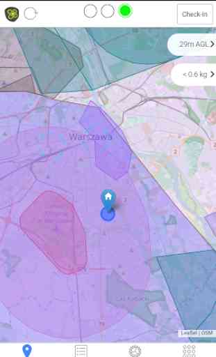
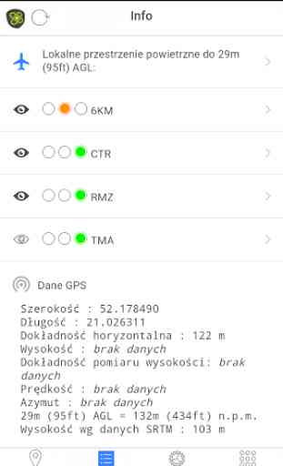
Start-up the application, allow for location services and observe the three lights at the top of the screen.
GREEN
- you can conduct your flightYELLOW
- restrictions are in place. You can check them by using the “Airspace” icon, where you can find contact details of the airspace ownerRED
- flight prohibited
Check-in registrationIn order to notify other airspace users about your flight, use the “Check-In” button in the right upper corner of the screen. Enter your contact details and the UAV type you are sing. This information is voluntary so it should be true. Confirm your location. An airspace area 500m in radius and up to declared height AGL will be marked on the DroneRadar system map for declared period.
Safe and happy flights !The DroneRadar Team
dlapilota.pl Sp. z o.o. the DroneRadar creator reserves the right to turn off service and/or updates at any time
Category : Maps & Navigation
Reviews (13)
Worst map ever, keeps jumping back to your current position and you have no clue what the colours mean.
Hard to find out what colors mean! I have a blue color stretching over many Kilometer in Gdynia no clue what it means. All selections in details green only one yellow. Where is explanation if can fly or not?? So they points marked green ok to fly even it says no Drone flights permitted??
Worthless only works in Europe not in the US. Don't bother downloading it.
I have to use the app for there in the pathway emergency airplane and helicopter
App don't work with android 9.1.0, firebase ini error
Some countries are not supported without saying
It doesn't cover Great Britain.
Does not work of huawei.
It does not support R. O. Ireland.
Must have with The drona
ins uav; best hummer
Required POLISH PHONE NUMBER to use it WHAT A JOKE!!!!!! No good for holiday in Poland
I'm sure that it does the right things for the government agencies, but the user experience is terrible. Lack of explanations on many things and where there are explanations, they are not clear at all. Potential to be a great app and service, but it needs to be easier to use