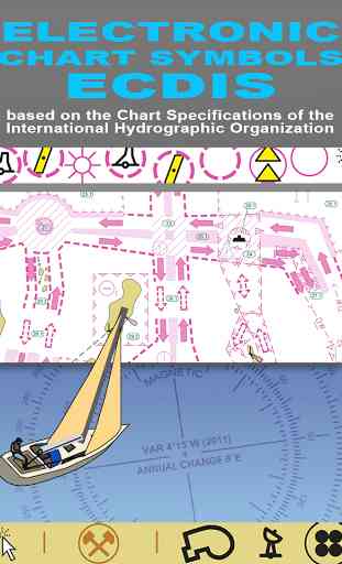
Electronic Chart Symbols ECDIS
QUICK REFERENCE GUIDE TO THE SYMBOLS USED ON ELECTRONIC (ECDIS) NAUTICAL CHARTS SPECIFIED BY THE INTERNATIONAL HYDROGRAPHIC ORGANIZATION (IHO).
***********
* FEATURES and BENEFITS ************
- Perfect for reference, learning & revision
- Hi-res graphics
- Tap & Enlarge feature for greater detail
- Fully searchable index to all the symbols
- Always with you on your iPhone or iPad
- No internet connection needed
- How to navigate safely!
***********
* Plus FREE Bonus Content from our "Safe Skipper" app ***********
*
"ELECTRONIC NAUTICAL CHART SYMBOLS & ABBREVIATIONS" provides quick reference to the "INT 1" symbols specified by the International Hydrographic Organization (IHO) on how to navigate safely.
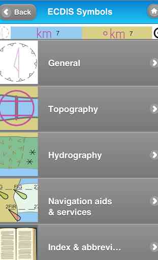
There are five main sections in this app, each with lettered sub-sections organized into categories to guide users through the hundreds of symbols. The main sections are:
GENERAL
- chart layouts, positions, distances, directions and compass.
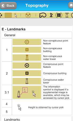
TOPOGRAPHY
- landmarks, ports and coastal land features.
HYDROGRAPHY
- tides, currents, depths, nature of the seabed, underwater obstructions, tracks, areas, limits and hydrographic terms.
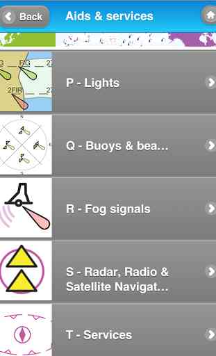
NAVIGATION AIDS & SERVICES
- lights, buoys, fog signals, radar, radio, services and small craft facilities.
INDEX & ABBREVIATIONS
- international abbreviations and index to symbols and abbreviations.
************
* FREE Bonus Content from "Safe Skipper" ****************************
* A bonus section has tips on how to deal with emergencies including: Abandon ship; Dismasting; Distress Signals; Engine Failure; Fire Fighting; Flares; Getting a tow; Helicopter rescue; Holed hull; Man overboard; Medical emergency; Mayday; Panpan; Securité.
INDEX The index is an A-Z of symbols and abbreviations and enables the user to quickly look up the symbols and see them in context with others in the same categories. This app is based on the United Kingdom Hydrographic Office's print publication "Chart 5011 (INT 1) EDITION 2" Admiralty Charts Publication and "Chart No.1 United States of America Nautical Chart Symbols, Abbreviations and Terms".
We have an on-going program of marine navigation and boating safety and reference apps, so please contact us with any ideas or features that you would like to see included.
***********
* FEATURES and BENEFITS ************
- Perfect for reference, learning & revision
- Hi-res graphics
- Tap & Enlarge feature for greater detail
- Fully searchable index to all the symbols
- Always with you on your iPhone or iPad
- No internet connection needed
- How to navigate safely!
***********
* Plus FREE Bonus Content from our "Safe Skipper" app ***********
*
"ELECTRONIC NAUTICAL CHART SYMBOLS & ABBREVIATIONS" provides quick reference to the "INT 1" symbols specified by the International Hydrographic Organization (IHO) on how to navigate safely.
There are five main sections in this app, each with lettered sub-sections organized into categories to guide users through the hundreds of symbols. The main sections are:
GENERAL
- chart layouts, positions, distances, directions and compass.
TOPOGRAPHY
- landmarks, ports and coastal land features.
HYDROGRAPHY
- tides, currents, depths, nature of the seabed, underwater obstructions, tracks, areas, limits and hydrographic terms.
NAVIGATION AIDS & SERVICES
- lights, buoys, fog signals, radar, radio, services and small craft facilities.
INDEX & ABBREVIATIONS
- international abbreviations and index to symbols and abbreviations.
************
* FREE Bonus Content from "Safe Skipper" ****************************
* A bonus section has tips on how to deal with emergencies including: Abandon ship; Dismasting; Distress Signals; Engine Failure; Fire Fighting; Flares; Getting a tow; Helicopter rescue; Holed hull; Man overboard; Medical emergency; Mayday; Panpan; Securité.
INDEX The index is an A-Z of symbols and abbreviations and enables the user to quickly look up the symbols and see them in context with others in the same categories. This app is based on the United Kingdom Hydrographic Office's print publication "Chart 5011 (INT 1) EDITION 2" Admiralty Charts Publication and "Chart No.1 United States of America Nautical Chart Symbols, Abbreviations and Terms".
We have an on-going program of marine navigation and boating safety and reference apps, so please contact us with any ideas or features that you would like to see included.
Category : Sports
Related searches
Reviews (3)
Stu. B.
Apr 3, 2014
Bought this to go with the paper charts one, v useful to carry around and always have handy when out on the water.
Sta. F.
Oct 16, 2014
Twice looked for an odd symbol and didn't find it. Don't waste your money!
Nice little app. There is more info on the free US Chart No 1 pdf but it's not as quick to navigate as this. Good to have in your pocket.