FieldCompanion
The FieldCompanion application supports you in guiding agricultural machinery and managing the data generated by your work.
Practical and intuitive, FieldCompanion is intended to be the indispensable technological companion in the field.
Developed by a farmer and a computer scientist, our software was born in the very place where it is used: In the cabins of vehicles !
Since 2003, we have been offering solutions in the field of precision farming. FieldCompanion is the logical sequel to the Track' n' Guide software for mobile devices.
FieldCompanion can be useful for any kind of work: spraying, fertilization, harvesting, seeding, etc.
It allows you to precisely configure your antenna and tools to visualize your tracks, assist you in guiding your vehicle and save your work in real time.
The different functionalities of FieldCompanion:
Provide and permanently store all data of the work performed automatically:
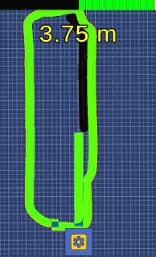
* Tracing the vehicle's route, geolocation by GPS
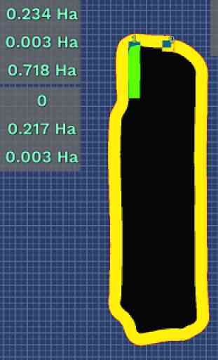
* Calculate area worked and overlapping areas
* Determine the perimeter and area of the field according to the worked areas
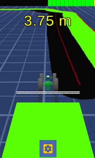
* Indicate the distance and direction from the last area worked.
* Reload all this information in order to resume unfinished work
Easily connect to your GPS/GNSS equipment:
* Via Bluetooth or internal receiver
* Take into account the actual position of the antenna in relation to the vehicle
* Back up the last configured device and reconnect automatically
* Compatible with the NMEA2000 standard and supporting update frequencies from 1Hz to 20Hz
Assist in guiding in relation to the previous track, starting from:
* Visualization of a parallel line
* A guide strip (lights) and distance indicator
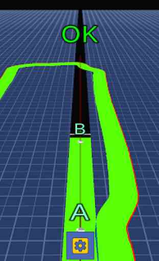
Two guidance systems are accessible:
* Free guidance: The parallel to the path is automatically displayed when approaching a previous path.
* AB guidance: Once a point A and point B have been defined, a succession of parallel lines is displayed as the vehicle approaches.
Configure your work tool to accurately reproduce the equipment used:
* Take into account the actual working width by determining at will the number of sections available to the tool (from 1 to 16), sub-sections (1 to 16 per section) and the size of sub-sections.
* Determine the position of the implement in relation to the vehicle and its angle of rotation.
* View sub-sections currently overlapping
* Save the configuration and reload it automatically
Customize its interface:
* Change the color of the main elements: Floor and its grid, work path and overlapping, guidance line.
* Set the guide strip (10 to 100 LEDs, representing a distance of 5cm to 1m) and the distance indicator (3 possible display sizes)
* Choose your language. 4 versions are currently available: French, Spanish, English and German.
Functions under development
Field management modules:
* Surrounding saving and reloading:
* Calibration tool to adjust the circumference position according to the current vehicle position.
GPS/GNSS receiver:
* Ability to connect equipment with USB and Ethernet connection (WiFi)
* Replay /Read the last work done instead of the demo file
Working width adjustment module:
* To be able to indicate whether the machine is front mounted, towed or suspended.
* Percentage overlap
Global features:
* Configuration of units (metric or imperial)
* Overlap deactivatable
Our goal is to offer a serious and reliable alternative accessible to all. This version is free and not limited; it is in constant evolution. Do not hesitate to share your ideas with us !
Practical and intuitive, FieldCompanion is intended to be the indispensable technological companion in the field.
Developed by a farmer and a computer scientist, our software was born in the very place where it is used: In the cabins of vehicles !
Since 2003, we have been offering solutions in the field of precision farming. FieldCompanion is the logical sequel to the Track' n' Guide software for mobile devices.
FieldCompanion can be useful for any kind of work: spraying, fertilization, harvesting, seeding, etc.
It allows you to precisely configure your antenna and tools to visualize your tracks, assist you in guiding your vehicle and save your work in real time.
The different functionalities of FieldCompanion:
Provide and permanently store all data of the work performed automatically:
* Tracing the vehicle's route, geolocation by GPS
* Calculate area worked and overlapping areas
* Determine the perimeter and area of the field according to the worked areas
* Indicate the distance and direction from the last area worked.
* Reload all this information in order to resume unfinished work
Easily connect to your GPS/GNSS equipment:
* Via Bluetooth or internal receiver
* Take into account the actual position of the antenna in relation to the vehicle
* Back up the last configured device and reconnect automatically
* Compatible with the NMEA2000 standard and supporting update frequencies from 1Hz to 20Hz
Assist in guiding in relation to the previous track, starting from:
* Visualization of a parallel line
* A guide strip (lights) and distance indicator
Two guidance systems are accessible:
* Free guidance: The parallel to the path is automatically displayed when approaching a previous path.
* AB guidance: Once a point A and point B have been defined, a succession of parallel lines is displayed as the vehicle approaches.
Configure your work tool to accurately reproduce the equipment used:
* Take into account the actual working width by determining at will the number of sections available to the tool (from 1 to 16), sub-sections (1 to 16 per section) and the size of sub-sections.
* Determine the position of the implement in relation to the vehicle and its angle of rotation.
* View sub-sections currently overlapping
* Save the configuration and reload it automatically
Customize its interface:
* Change the color of the main elements: Floor and its grid, work path and overlapping, guidance line.
* Set the guide strip (10 to 100 LEDs, representing a distance of 5cm to 1m) and the distance indicator (3 possible display sizes)
* Choose your language. 4 versions are currently available: French, Spanish, English and German.
Functions under development
Field management modules:
* Surrounding saving and reloading:
* Calibration tool to adjust the circumference position according to the current vehicle position.
GPS/GNSS receiver:
* Ability to connect equipment with USB and Ethernet connection (WiFi)
* Replay /Read the last work done instead of the demo file
Working width adjustment module:
* To be able to indicate whether the machine is front mounted, towed or suspended.
* Percentage overlap
Global features:
* Configuration of units (metric or imperial)
* Overlap deactivatable
Our goal is to offer a serious and reliable alternative accessible to all. This version is free and not limited; it is in constant evolution. Do not hesitate to share your ideas with us !
Category : Auto & Vehicles
Related searches